

weatherwiz
-
Posts
76,464 -
Joined
-
Last visited
Content Type
Profiles
Blogs
Forums
American Weather
Media Demo
Store
Gallery
Posts posted by weatherwiz
-
-
-
That is going to pass extremely close to Alexandria International airport (AEX)
I have their METAR up and trying to find airport web cams!!!!
-
Just now, dendrite said:
We unpress?
Do you know of any place where you can access any airport web cam???? Need one QUICK
-
3 minutes ago, dryslot said:
In years past, It has performed well in these types i have always thought, Not so much in Miller A's or B's though.
with totals?
I have always thought that they handled well such aspects as where the max totals will be and hinting at what the upper range of totals may be
-
2 minutes ago, ORH_wxman said:
Here's an example....look at the 6 hourly snowfall between 12z and 18z....notice that really sharp gradient just N of the pike. The QPF doesnt look like that either...it's only the snow that does. Yet the snow line at 12z is still down in central CT/RI. So it is assuming that the changeover to sleet happens in the BOS-ORH corridor extremely fast after 12z and then halfts for 4-5 hours just north of them....which isn't very realistic. So you get these weird banded looks on the clown maps. It's a good example why not to rip and read them....esp if you are in a zone that transitions between snow and another ptype in between 6 hour panels.
yup...not only are they garbage to begin with but add p-type issues into the picture and they become worse than garbage. Only thing perhaps realistic about that is the potential max area
Just now, dryslot said:Some had laughed at the GFS but it has been pretty steadfast BL issues not included bringing this pretty far north from being the outlier to most all the others moving towards it.
That should have always been a player on the table...scenarios like that are not uncommon in these setups
-
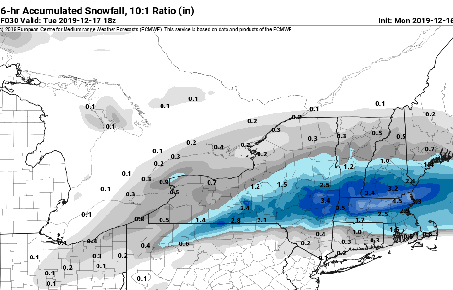
Given the Euro joining the train this afternoon I think we see winter storm warnings fly. Going to be a nice strip of 4-8''
-
There is a purpose to this thread...want to start collecting information, thoughts, and ideas for bigger events which can be a tool for research purposes down the road.
An extremely unseasonably conducive environment for severe weather (including tornadoes and strong tornadoes) exists across the Gulf coast states. A somewhat uncommon winter-time elevated-mixed layer has advected into the region from the Mexican plateau and is characterized by mlvl lapse rates on order of ~7.5 C/KM. Below the EML exists an extremely moist airmass with sfc dews in the 60's and 70's. This is contributing to MLCAPE values on order of 1500 J/KG with 3km CAPE values greater than 125 J/KG. Couple with with 50+ knots of vertical shear and effective helicity > 300 m2s2 and this is the result...

A large and destructive tornado is currently on the ground over Leander, LA. This has been a long-tracked tornado and given the environment may be on the ground for quite a while.
-
Even looks like the coast could see 2-3'' on the euro...nice.
-
Can we do a severe wx thread in this subforum that's dedicated to severe wx outside of New England? Would be good practice for when our season heats up
-
 2
2
-
 1
1
-
 2
2
-
-
1 minute ago, moneypitmike said:
What is the bearing of this for tomorrow?
TIA.
For tomorrow...Some of those areas will likely be without power for a while
-
1
-
2
-
-
Taking a quick look at the south...
1500+ MLCAPE, 150 3km CAPE, all under 300+ effective helicity and 50+ knots 0-6km shear.
uh-oh

-
Just now, Go Kart Mozart said:
FOUS shows the surface winds starting at 60 degrees, and backing to 40 through the event. I don't think the Sound is a big deal here.
It's always tough...even when you think the sound will be of zero influence it still seems to be a factor lol.
What I think happens is there is still enough of a gradient between land/ocean that you still generate at least a localized and very confined area of winds with a southerly/easterly component...it's just so localized and small models won't pick it up.
-
Just now, STILL N OF PIKE said:
Its a fraud 5 member.
I was on board the last one as something different than analfrontal ....your not getting me on the arctic front train
These type of fronts almost always are associated with snow squalls. these are different than polar fronts which are more common.
-
2 minutes ago, Ginx snewx said:
You and Dr Dews should shack up in the Mehiday Inn
Wednesday looks fun. Wish we had some steeper lapse rates involved b/c I would throw the lightning flags around.
Speaking of lightning...I hope they do some special balloon launches in the south today!!!
-
Just now, STILL N OF PIKE said:
and fourth when ZR is actually sleet along northern areas of ZR clown maps
These things are even worse than the snow maps
-
3 minutes ago, ORH_wxman said:
Yeah it's possible half an inch happens, I'm just pretty skeptical of it. Nothing wrong with using it as the upper bound though...upper bound should be where if most things go right.
All these things to consider:
- QPF could be overdone in general on some of these mesos
- Lose some ZR QPF to sleet where algorithms are too quick to flip to ZR
- Accretion efficiency? It can vary quite a bit depending on precip rate, temps, wind, etc...but median is about 0.70.
As an aside, I actually always thought the ice storm warning criteria of half an inch of ice was kind of dumb and arbitrary anyway. Grid problems start ramping up quickly at around a third to 3/8 of an inch I've noticed.
I agree...also 1/2'' of ice isn't very easy to get. We def start getting problems with less...especially if there is accumulating snow involved just prior.
-
22 minutes ago, The 4 Seasons said:
Going big with the ice i see. I am likely bumping up the .1-.3 range to .25-.50, our zones are the same though. My biggest problem though is forecasting the shore, you think they dont see any ice accumulation at all? I dont think itll be as big as inland areas but still have up to a tenth or so..
The immediate shoreline is tough...with it still being early in the season it doesn't take much of a easterly component to the wind to bump sfc temps just above freezing. I think they may see some...but probably generally under .10''.
-
This storm is going to be super exciting. We get to track a tornado outbreak in the south today and then quickly shift gears and watch us get snow and ice.
-
Updated forecast
WOAH at the SPC outlook

“environment will support risk for multiple significant tornadoes”

-
1
-
 1
1
-
-
Just now, JGNYK03 said:
Ya ground zero seems to be from merritt parkway to 84. North of there more sleet, south of there maybe just above freezing. Every single piece of guidance agrees on this.
I think you may have mentioned that could be the focal zone the other day...pretty solid call. Now it's just a matter of how much ZR we're talking about.
-
Holy smokes
-
3 minutes ago, RUNNAWAYICEBERG said:
Damn rgem juicy with the thump in CT then big time icing.
yeah the RGEM has me pretty damn concerned. that's a pretty decent signal across central CT.
-
Just now, RUNNAWAYICEBERG said:
Let’s not forget how dumb folks are thinking it’s rain when it’s zr so they drive like they normally do.
I love the famous "I have 4-wheel drive I'll be fine" line (it's ice not snow...unless your tires have custom made ice skates...good luck)
-
Just now, WxWatcher007 said:
Me too, but I think an upper end of 5” works here because pingers are never as far behind as one thinks down here. I’m hesitant to pull the trigger on a big icing forecast but I think it’s a legit mess.
I typically bump up the expected changeover by an hour or two from what models indicate. Yeah I'm not sure if this will be a big icing event...but we may straddle the line between issues and a bit more in the way of major issues (major issues being scattered power outages and some tree damage)
-
1
-


January 10-11 Severe Weather Threat
in Central/Western States
Posted
I think this is looking rather concerned across eastern TX into LA. That's a pretty significant EML advecting in from the Mexican Plateau characterized by mlvl lapse rates which may be in excess of 8.5-9 C/KM...typically I would be concerned about extremely strong capping, however, not with this forcing present. What this CAN, however, result in is a "less messy" warm sector with stronger heating than modeled...when you're talking about mlvl lapse rates that steep with sfc dews ~70...CAPE can become significant...1500-2000 J/KG of MLCAPE is very possible. bufkit soundings (IAH) also indicating > 500 J of 6km CAPE with > 45 m/s of shear...yikes.
Obviously shear orientation will result in a mixed storm mode, but we could be looking at a long-lived QLCS (I saw derecho mentioned and certainly can't disagree) with embedded tornadoes (perhaps a significant one) along with discrete supercells (especially Friday afternoon into early overnight) capable of tornadoes and a few intense tornadoes. There may also be some pretty large hail too...