

weatherwiz
-
Posts
81,132 -
Joined
-
Last visited
Content Type
Profiles
Blogs
Forums
American Weather
Media Demo
Store
Gallery
Everything posted by weatherwiz
-

Possible coastal storm centered on Feb 1 2026.
weatherwiz replied to Typhoon Tip's topic in New England
What really sucks about this is it is nearly impossible to gauge the validity of that aspect until real time (or at least not until within 6-12 hours). -
Possible coastal storm centered on Feb 1 2026.
weatherwiz replied to Typhoon Tip's topic in New England
Also, the size of that high pressure system is massive, stretching from the upper-Midwest into southeast Canada southwest into the southern Plains...that as well argue for something farther north and west for track -
Possible coastal storm centered on Feb 1 2026.
weatherwiz replied to Typhoon Tip's topic in New England
Yup...this is a model weakness in these airmasses. Forecast models don't have the necessary resolution to accurately handle this so you'll see the models just want to put the low where the warm air is. We certainly can't rule out a dual low structure either and there is a chance that this system has more in the way of convection associated with it which adds additional problems (as we know) -
Possible coastal storm centered on Feb 1 2026.
weatherwiz replied to Typhoon Tip's topic in New England
Yeah we definitely do not want this thing closing (at H5) too early. I think we'd even want it to be a bit farther north than Norfolk in a perfect world. But if we can dig that trough slightly more west and deeper that would certainly help tug this west a bit. However, thinking about this more closely, I question as to whether we would want this to dig more west and deep...if that happens we could run the risk of tracking this up right along the coast or even slightly inland. -
Possible coastal storm centered on Feb 1 2026.
weatherwiz replied to Typhoon Tip's topic in New England
Agreed, my guess is we see changes in our favor. -
Possible coastal storm centered on Feb 1 2026.
weatherwiz replied to Typhoon Tip's topic in New England
There isn't much I really see, at least on the large-scale, that indicates this would go out to sea. Now, that doesn't mean this can't end up tracking far enough away that it only grazes the coast but I don't see a totally OTS solution here. I like the building -NAO too, particularly west based. I guess ultimately it would be best to get the 500 energy to dig slightly more west into Alabama but not a big issue at this stage -
Possible coastal storm centered on Feb 1 2026.
weatherwiz replied to Typhoon Tip's topic in New England
Keep in mind the struggle the models have with the shallow nature of Arctic airmasses. Where the GFS and even Euro are developing the sfc low off the Carolina coast...probably shift that 50-75 miles farther northwest along the with whole storm track. I think this one has a great chance of passing right over the benchmark. The only thing I don't want to see is this bomb to something into the 980's or lower. -
Possible coastal storm centered on Feb 1 2026.
weatherwiz replied to Typhoon Tip's topic in New England
I still think this comes farther northwest. The 0z Euro was add to with the H5 vort. I don't think this vort is real...might be associated with convection and it seems the Euro then shifts the focus of evolution to this vort and results in south and east.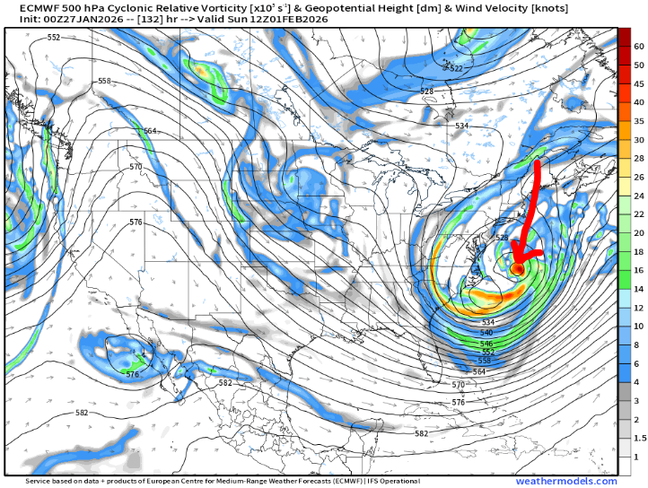
-
Possible coastal storm centered on Feb 1 2026.
weatherwiz replied to Typhoon Tip's topic in New England
That is a damn impressive signal this far out. I bet if this was inside 48 hours we would be seeing widespread 2"+ QPF...the inflow flux off the Atlantic in this would probably be even greater than this past weekend and the large-scale VVs would probably be much greater as we'd be developing closed mlvl circulations -
Possible coastal storm centered on Feb 1 2026.
weatherwiz replied to Typhoon Tip's topic in New England
gotcha...I was very confused for a second haha. -
Possible coastal storm centered on Feb 1 2026.
weatherwiz replied to Typhoon Tip's topic in New England
yeah I'll do without a sub 970 low please...hell I'll do without sub 980 -
Possible coastal storm centered on Feb 1 2026.
weatherwiz replied to Typhoon Tip's topic in New England
I'm confused with this. Are you saying you think the GFS will eventually come more NW? If so, that's what I was referring to -
Getting a nice, steady light snow shower
-
Possible coastal storm centered on Feb 1 2026.
weatherwiz replied to Typhoon Tip's topic in New England
Going to go with what my professor talked about with this past storm and how the GFS tends to be too far south and east with developing low pressures with Arctic boundaries around. GFS tends to develop them more towards the warmer side of the boundary (or a bit south and east of the boundary) when the reality is they tend to develop right along the Arctic boundary. Models can struggle with Arctic boundaries because the depth of the Arctic cold is on the shallower side -
Possible coastal storm centered on Feb 1 2026.
weatherwiz replied to Typhoon Tip's topic in New England
I would lean towards the 12z GFS being too far south and east -
It was really difficult to get a final measurement because once the winds picked up the snow began blowing around. When I measured around 7:30 (had 11.5") and went back out before bed around 9:30, there was minimal additional accumulation and that's during the period when the winds started picking up. But judging by how it continued to snow through I went to bed I have to say the total was about 13-14". Depth is probably very close to 18".
-
The end of the driveway probably has 3-4 feet of snow. I almost don't even want it touched, it's like a Van Gogh painting; master artwork. You just want to stare at it, and admire it and think dirty thoughts
-
Oh absolutely. Just pointing it out more for the science behind the scenes aspect. So this isn't anything to knock down or play down the storm or intensities ordeal but it just goes to show how extremely difficult it is to get a storm where you have a consistent ratio. Now, at the end of the day, total wise it may not truly matter (except when talking about very high end stuff)...so it was a factor in why we didn't see widespread 20-30" type stuff but for those forecasting it's something that really needs to be given thought when making a forecast. We all won on this one
-
I was watching some map discussion video lectures from my professor last night which he posted Thursday and Friday doing model analysis. In his discussion from Thursday he talked about several things which hinted that not only the storm would take on a more northerly track but why the GFS initially was a bit far south and east than some of the other guidance was at the time. He pointed things out in model guidance Thursday and gave his opinion on how he thought the storm would unfold and he was pretty spot on.
-
I am not shocked about this really. Using the obb method on bufkit you could see the snow ratio line looking like that of a seismograph when there's an Earthquake lol. On any profile, there never really was a good consistent duration where snow ratio was constant...it was very jumpy.
-
Bring it on...let's let the remainder of winter go out with a bang.
-
Two weeks ago winter was cancelled because the "lack of snow cover". My oh my how things can change. Only takes one storm to switch the tune
-
Just such a massive area, well into NY/NJ/PA. Imagine if we could get one or two of these every winter
-
What a day, what a night. This is beautiful and everyone won
-
Definitely drifting going on out there. Anywhere from about 12-12.5" Went 10-15" so well within that range. Maybe even tack on another inch or two. Headed to bed...curious to see what it compacts down to when I check around 5:30


