weatherwiz
-
Posts
81,132 -
Joined
-
Last visited
Content Type
Profiles
Blogs
Forums
American Weather
Media Demo
Store
Gallery
Everything posted by weatherwiz
-

“Cory’s in LA! Let’s MECS!” Jan. 24-26 Disco
weatherwiz replied to TheSnowman's topic in New England
If we're going to be looking at something along the line of 15-20-24" somewhere that idea won't become more serious until we're inside of 24-36 hours and can start diagnosing banding more accurately and getting a solidified feel on snowfall ratios, lift, etc. This is why that map of 1-2' was absolutely stupid this far out. -
“Cory’s in LA! Let’s MECS!” Jan. 24-26 Disco
weatherwiz replied to TheSnowman's topic in New England
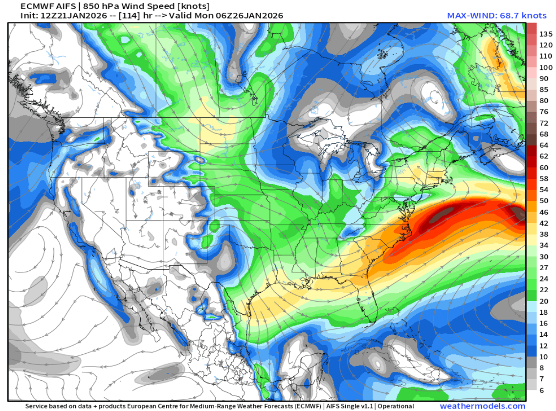
That would be a huge hit on the GFS, especially with the 850 low developing just south of the region. I like how the sfc low and 850 low go virtually west-to-east to our south with a bit of elongation to the low...that should help (I would think) result in a much wider than usual fronto band (combined with other factors of course) than usual. This inflow oof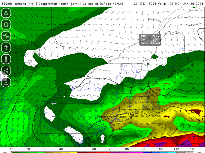
-
“Cory’s in LA! Let’s MECS!” Jan. 24-26 Disco
weatherwiz replied to TheSnowman's topic in New England
For old times sake can we have the storm mode in bright red at the top of the page? maybe a radio show too -
“Cory’s in LA! Let’s MECS!” Jan. 24-26 Disco
weatherwiz replied to TheSnowman's topic in New England
I miss oceanstatewx insights with the NBM and its latest developments. Its not a bad source though I think it still has a quite a bit of room for improvement. I'm actually not entirely sure how it does with snowfall forecasts but I believe it can be a solid source because of its ability to bias correct -
“Cory’s in LA! Let’s MECS!” Jan. 24-26 Disco
weatherwiz replied to TheSnowman's topic in New England
Ask the chipmunk it squashed -
“Cory’s in LA! Let’s MECS!” Jan. 24-26 Disco
weatherwiz replied to TheSnowman's topic in New England
Only mixing between Sunday and Monday will be Bacardi with coke -
“Cory’s in LA! Let’s MECS!” Jan. 24-26 Disco
weatherwiz replied to TheSnowman's topic in New England
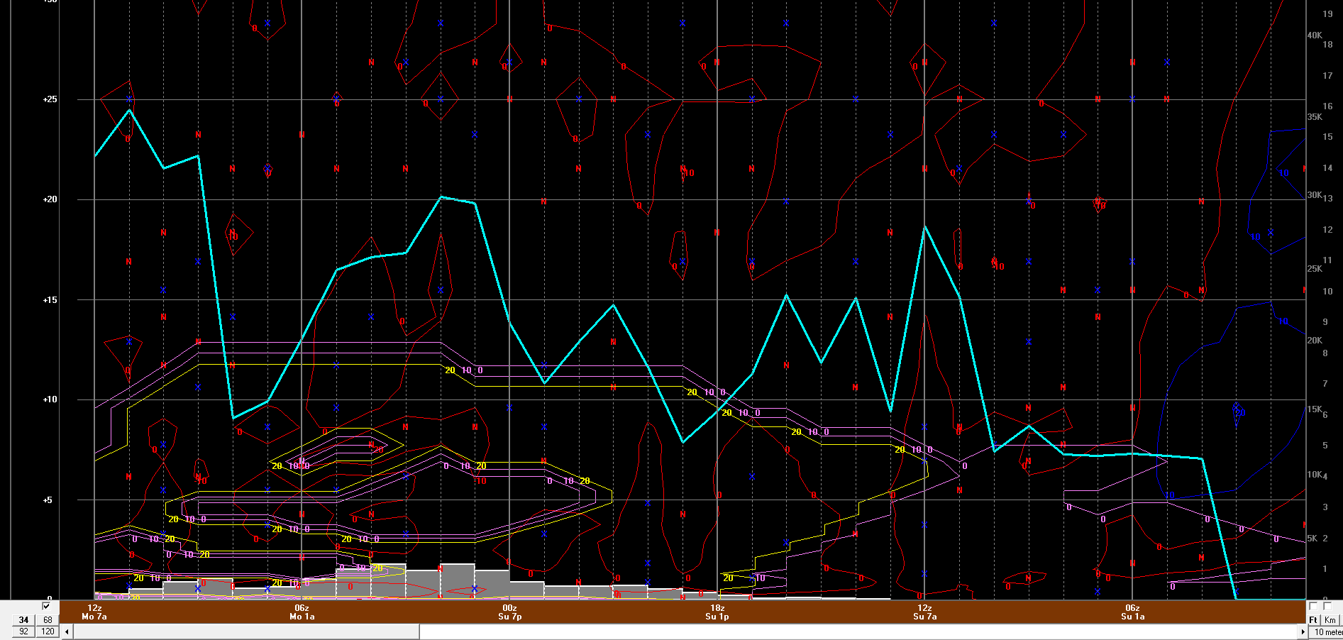
It is feasible the immediate shore does experience some mixing. This is where its much better to look at forecast soundings then fixed levels (such as 850 or 700). You can get very sneaky, subtle warm layers. There are also other processes to consider as well, for example, if there is a tremendous amount of latent heat release ongoing that can negatively impact snow growth production and result in poor enough snowgrowth that precip is almost sleet like. I believe something like that happened in 2013? -
“Cory’s in LA! Let’s MECS!” Jan. 24-26 Disco
weatherwiz replied to TheSnowman's topic in New England
Just wait until we get the ice storm warnings cranking -
“Cory’s in LA! Let’s MECS!” Jan. 24-26 Disco
weatherwiz replied to TheSnowman's topic in New England
Given the airmass, the trend could actually be a significant benefit to us, at least on the mesoscale level when it comes time to pinning down banding and what the potential amounts may be -
January 2026 regional war/obs/disco thread
weatherwiz replied to Baroclinic Zone's topic in New England
Oh wow look outside and a nice, steady snow falling -
“Cory’s in LA! Let’s MECS!” Jan. 24-26 Disco
weatherwiz replied to TheSnowman's topic in New England
All the details and such can be ironed out as we get closer but there is a ton to be excited and happy about at this time range. There is going to be no shortage of moisture with this and if we can get the final evolution to be very close to what the general consensus is, it's going to be a big hit over a very large area - obviously there will be mesoscale factors at play which result in some getting "screwed" and some "overperforming" but lets keep this signal for a powerhouse of WAA feeding into the airmass that will be in place, and with the thermal profile and temperature gradient (upward) velocities would be great over the entire area -
“Cory’s in LA! Let’s MECS!” Jan. 24-26 Disco
weatherwiz replied to TheSnowman's topic in New England
Went to the AMS in Austin in 2018 and we got stuck in Austin for an extra two days because our flight got cancelled for wintry precip. The whole town of Austin was virtually shut down...not a single car on the road. They legit got like 2 second of sleet haha. Missed the first two days of the spring semester. -
“Cory’s in LA! Let’s MECS!” Jan. 24-26 Disco
weatherwiz replied to TheSnowman's topic in New England
I see it now...I looked further ahead to Sunday with I guess if you want to call it the second wave -
“Cory’s in LA! Let’s MECS!” Jan. 24-26 Disco
weatherwiz replied to TheSnowman's topic in New England
Wow I'm shocked to see Winter Storm Watch as far south as Houston (looks like for ice)...I don't see anything indicating they will get icing that far south. I know that far south it takes like 3 drops of frozen liquid but very odd -
“Cory’s in LA! Let’s MECS!” Jan. 24-26 Disco
weatherwiz replied to TheSnowman's topic in New England
Right Probably something you'd see in like central Alaska lol -
“Cory’s in LA! Let’s MECS!” Jan. 24-26 Disco
weatherwiz replied to TheSnowman's topic in New England
This is wild ha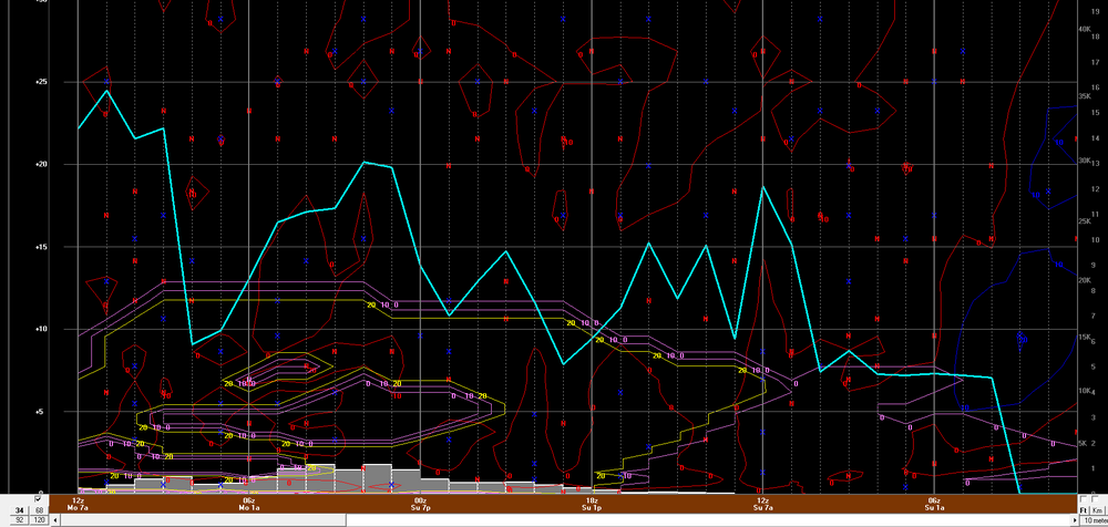
-
“Cory’s in LA! Let’s MECS!” Jan. 24-26 Disco
weatherwiz replied to TheSnowman's topic in New England
Ahh this makes sense. I hate how products are limited on weathermodels but my initial thinking was whether the 12z Euro was like occluding things a bit quicker the way it was kind of tapering down the QPF towards the end. -
“Cory’s in LA! Let’s MECS!” Jan. 24-26 Disco
weatherwiz replied to TheSnowman's topic in New England
Any mixing issues would probably be more towards the end of the storm...I don't think mixing would be an issue during the bulk -
“Cory’s in LA! Let’s MECS!” Jan. 24-26 Disco
weatherwiz replied to TheSnowman's topic in New England
I'll take QPF underdone for $1000, please
-
“Cory’s in LA! Let’s MECS!” Jan. 24-26 Disco
weatherwiz replied to TheSnowman's topic in New England
1-1.5" of QPF in that airmass, especially if you're maximizing lift is going to produce some significant snowfall accumulations. That would certainly be high end...unless we're using something like 2-3 feet to define high end lol -
January 2026 regional war/obs/disco thread
weatherwiz replied to Baroclinic Zone's topic in New England
Euro starting to load in on weathermodels -
January 2026 regional war/obs/disco thread
weatherwiz replied to Baroclinic Zone's topic in New England
I've noticed the euro has been a bit late the past several days (at least on weathermodels). Even the 12z GFS bufkit was late on pennstate today -
January 2026 regional war/obs/disco thread
weatherwiz replied to Baroclinic Zone's topic in New England
Verbatim on the GFS I think you would see a major band well up to the Mass Pike. Imagine if we were to pop at 700 low...damn -
January 2026 regional war/obs/disco thread
weatherwiz replied to Baroclinic Zone's topic in New England
dendrite should just create an algorithm that blocks the posting of snow maps -
January 2026 regional war/obs/disco thread
weatherwiz replied to Baroclinic Zone's topic in New England
I would also have to think too that processes involved in the evolution of this whole system across the southern states and across the East would end up far outweighing any influence of the MJO. I actually can't wait because this very subject is on the agenda in my advanced forecasting class