weatherwiz
-
Posts
81,132 -
Joined
-
Last visited
Content Type
Profiles
Blogs
Forums
American Weather
Media Demo
Store
Gallery
Everything posted by weatherwiz
-
 just turned on the camera and set to time lapse mode!
 -
snow has commended LFG LFG!!!!!
-
Wasn't there an accident in that same spot too like a few days ago? All the years I lived in West Hartford I don't think I had ever got off on that exit or been with anyone driving who has lol
-
Is that Rt. 8?
-
And he had to check the 12z Euro so he could come in here to tell us it looked good, 2 hours after we already knew this
-
I don't think he is nitpicking as much as he is being realistic. People are going nuts with this widespread 20" stuff because of Kuchera maps
-
As always one of the best products to watch as an event is ongoing (besides radar)
-
I do have an older phone actually. Switched my gf to my phone plan so she got a new phone and gave me her older one. I just have to finish setting it up. Will be great for storm chasing because I can have one phone for radar and one for recording.
-
that's what I have the camera on but I also need my phone.
-
I'm not going to stand at the window for 12 hours and hold my phone up
-
I never made it out I'll just have to use a tape measurer but there is noting like holding the nice thick wood of a yard stick and sticking it into the snow
-
Got my camcorder all setup. Going to have it rolling all day doing a time lapse of the yard
-
Looking around at overnight guidance I would say during the meat of the snow the ratios are probably around 14:1 to 17:1 average and outside of the meat of the snow they will be closer to 10:1.
-
“Cory’s in LA! Let’s MECS!” Jan. 24-26 Disco
weatherwiz replied to TheSnowman's topic in New England
Holy freaking hell people have gone out of control with the Kuchera maps. -
“Cory’s in LA! Let’s MECS!” Jan. 24-26 Disco
weatherwiz replied to TheSnowman's topic in New England
put the TV in front of the window -
“Cory’s in LA! Let’s MECS!” Jan. 24-26 Disco
weatherwiz replied to TheSnowman's topic in New England
Very heavy snow for early-to-mid afternoon, potentially approaching 1.5-2 inches per hour during the peak which could persist for several hours. Moderate snow continuing into the evening before tapering off. Going to be at least a good foot for all (except maybe shoreline where it could be more 9-10") -
“Cory’s in LA! Let’s MECS!” Jan. 24-26 Disco
weatherwiz replied to TheSnowman's topic in New England
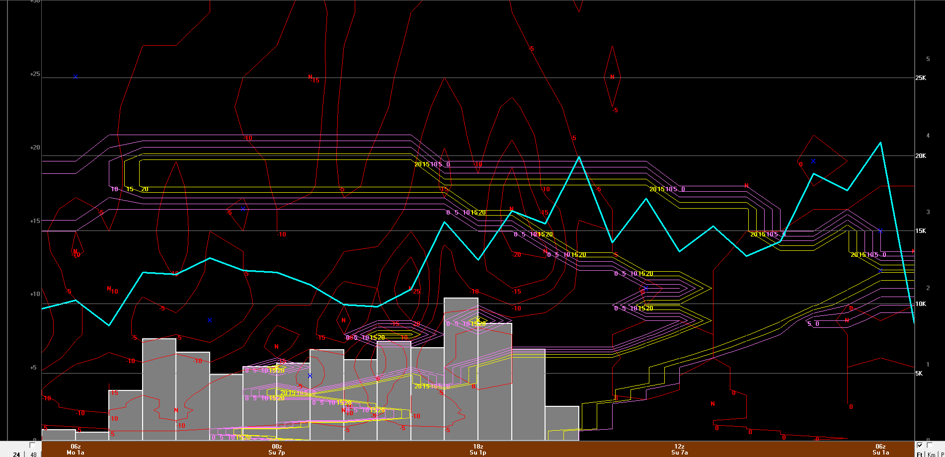
Forgot about the GFS Here's 12z GFS bufkit for BDL. Even a bit more intense than the NAM.
-
“Cory’s in LA! Let’s MECS!” Jan. 24-26 Disco
weatherwiz replied to TheSnowman's topic in New England
earlier this decade -
“Cory’s in LA! Let’s MECS!” Jan. 24-26 Disco
weatherwiz replied to TheSnowman's topic in New England
The Winter lecture my professor just posted for winter weather forecast actually has a slide on Kuchera method. One of the bullet points Does not account for vertical velocity, depth of DGZ, saturation of DGZ, dry layers near surface, time of year, or stability Often overpredicts snowfall in in very cold airmasses and in marginal/mixing situations -
“Cory’s in LA! Let’s MECS!” Jan. 24-26 Disco
weatherwiz replied to TheSnowman's topic in New England
That's why I am not a fan of the snow maps, all they do is just take forecast QPF and multiply that by a snow ratio. There is no factoring in of lift, snow growth, RH of the DGZ and RH with respect to ice crystals in the DGZ. What separates the Kuchera from 10:1 (besides the obvious being 10:1 maps are constant) is it factors in the average temperature of the llvls to compute a snow ratio. The Kuchera method I also believe was designed to be a tool for snowfall depth. There are a few moduels on MetEd which go into some depth on these maps. When it comes to verifying Kuchera versus what occurred, the results were/are not particularly great. -
“Cory’s in LA! Let’s MECS!” Jan. 24-26 Disco
weatherwiz replied to TheSnowman's topic in New England
I don't think that is true. The only method which factors in lift and omega is the cobb technique. What the Kuchera (and 10:1) do when it comes to max banding is highlight where the greatest QPF is forecast (by the model) and where that coincides with what the model believes will be all snow -
“Cory’s in LA! Let’s MECS!” Jan. 24-26 Disco
weatherwiz replied to TheSnowman's topic in New England
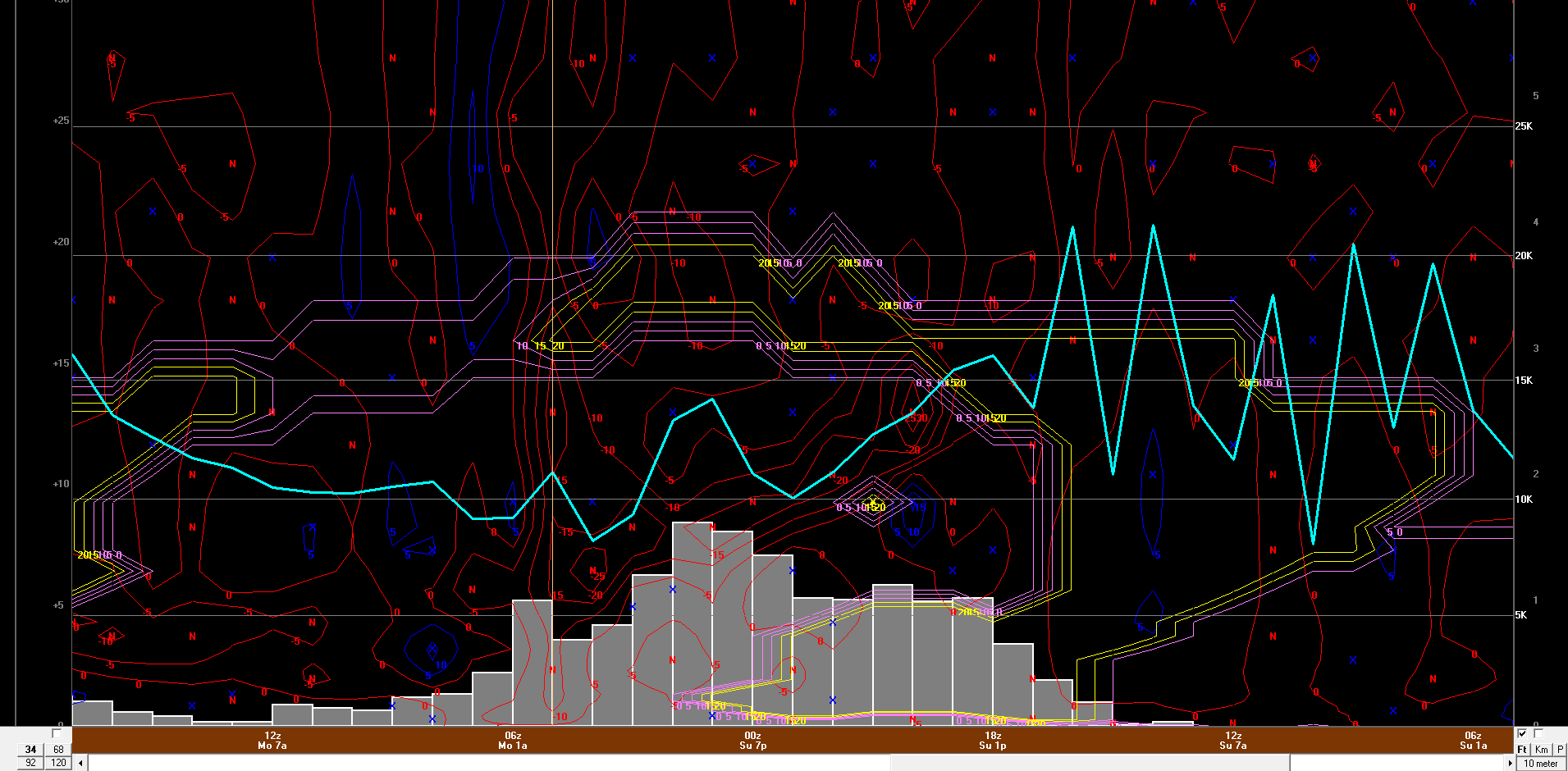
12z NAM bufkit BDL....LG....LFG. Look at that thump. And we get consistently good lift through the DGZ for the duration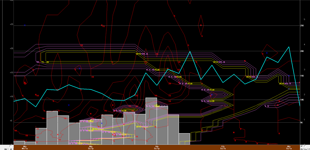
-
“Cory’s in LA! Let’s MECS!” Jan. 24-26 Disco
weatherwiz replied to TheSnowman's topic in New England
100% And speaking of that, the snow side of things is overperforming in parts of the South, particularly Arkansas at least -
“Cory’s in LA! Let’s MECS!” Jan. 24-26 Disco
weatherwiz replied to TheSnowman's topic in New England
This is going to be amazing. I don't want to use the T word but can it happen?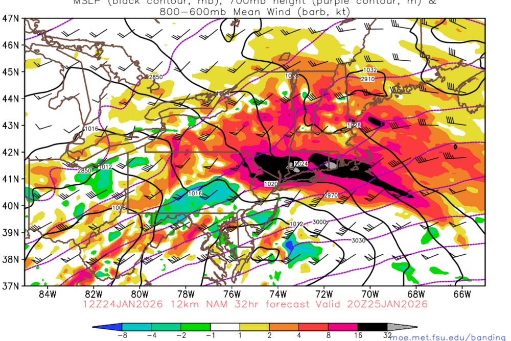
-
“Cory’s in LA! Let’s MECS!” Jan. 24-26 Disco
weatherwiz replied to TheSnowman's topic in New England
The method uses like an average temperature of the lower troposphere to determine a snow ratio. I think in these situations with the very cold llvls below an above warm layer, yes the Kuchera method would "inflate" the output. The Kuchera method is so terrible...equally as worse as 10:1 maps