weatherwiz
-
Posts
81,132 -
Joined
-
Last visited
Content Type
Profiles
Blogs
Forums
American Weather
Media Demo
Store
Gallery
Everything posted by weatherwiz
-
80 days to go!!!
-
The Sierra's are certainly going to be making up their snow deficit
-

Feb 10-11 Mid Week Minor Event - Ride the hot hand?
weatherwiz replied to HoarfrostHubb's topic in New England
Kind of wondering if there will be two favored areas for the best lift. One up your way and a second area into southwest CT...maybe even along the CT shoreline -
The second half of this month is going to be quite interesting. The pattern is going to become much more active, in fact, it's already making strides in that direction. Details TBD and folks can muster that up to fit their backyard mold but it certainly will not be a dull second half of the month
-
Friday February 6 FROPA / WINDEX small event
weatherwiz replied to HoarfrostHubb's topic in New England
2.5" -
Friday February 6 FROPA / WINDEX small event
weatherwiz replied to HoarfrostHubb's topic in New England
I was hoping we could get 1-1.5" so certainly was a nice little surprise in that regard. -
Friday February 6 FROPA / WINDEX small event
weatherwiz replied to HoarfrostHubb's topic in New England
Pretty wild...I always thought it would be like early afternoon when they got really crushed. Still looks like there is a bit to go before this is even maximized there. The totals are going to be absurd. Someone is going to pull off 20+" though once wind whips up good luck measuring -
Friday February 6 FROPA / WINDEX small event
weatherwiz replied to HoarfrostHubb's topic in New England
yeah may end up being the case. -
Friday February 6 FROPA / WINDEX small event
weatherwiz replied to HoarfrostHubb's topic in New England
Still hoping we see some thunder/lightning there -
Friday February 6 FROPA / WINDEX small event
weatherwiz replied to HoarfrostHubb's topic in New England
Wind starting to pickup a bit here -
Friday February 6 FROPA / WINDEX small event
weatherwiz replied to HoarfrostHubb's topic in New England
I think it’s pretty freaking awesome how guidance not only picked up on this localized max but was very consistent. -
Friday February 6 FROPA / WINDEX small event
weatherwiz replied to HoarfrostHubb's topic in New England
2.5”! -
I think the parade reference is should the Patriots win the Super Bowl. But also saying it's actually not terrible weather for a parade (compared to what we've had anyways).
-
Friday February 6 FROPA / WINDEX small event
weatherwiz replied to HoarfrostHubb's topic in New England
Can't even get TTs like that during the summer -
Friday February 6 FROPA / WINDEX small event
weatherwiz replied to HoarfrostHubb's topic in New England
Someone in Gloucester or Rockport is going to get lucky enough and probably pull off 8-9". Someone is going to be pulling off 3-4" per hour rates for a time with thunder/lightning going on. This signal has just been way too consistent and across multiple forecast models.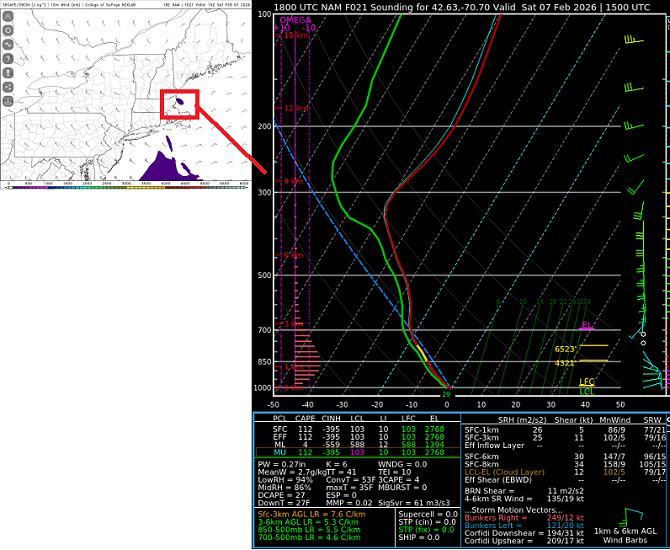
-
Friday February 6 FROPA / WINDEX small event
weatherwiz replied to HoarfrostHubb's topic in New England
GFS bufkit is nuts for Boston. Definitely supports warning criteria potential
-
Friday February 6 FROPA / WINDEX small event
weatherwiz replied to HoarfrostHubb's topic in New England
That is pretty insane to see. That would probably be a legit thunderstorm with 4" per hour rates lol. Maybe some waterspouts too -
Friday February 6 FROPA / WINDEX small event
weatherwiz replied to HoarfrostHubb's topic in New England
GFS too with the signal up around BOS -
Friday February 6 FROPA / WINDEX small event
weatherwiz replied to HoarfrostHubb's topic in New England
If upward vertical motion was greater over a widespread area I could see this but not sure we will have enough over a large area to support that. -
Friday February 6 FROPA / WINDEX small event
weatherwiz replied to HoarfrostHubb's topic in New England
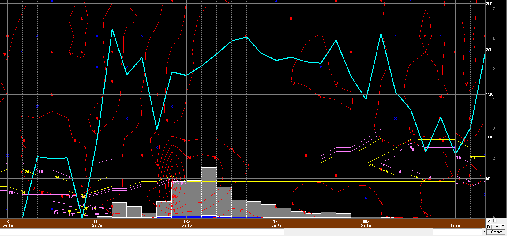
12z NAM bufkit for BOS. 30 ub/s of omega there. Although I am curious as to why the dip in snow ratio during the height
-
Friday February 6 FROPA / WINDEX small event
weatherwiz replied to HoarfrostHubb's topic in New England
Absolutely -
Friday February 6 FROPA / WINDEX small event
weatherwiz replied to HoarfrostHubb's topic in New England
Now I'm seeing some of those soundings. Not sure if this is a COD thing but sometimes the point-and-click soundings don't really match up to what you'd expect to be seeing. You'd have to wonder if some localized warning amounts are possible if this verified -
Friday February 6 FROPA / WINDEX small event
weatherwiz replied to HoarfrostHubb's topic in New England
oh no...I meant location -
Friday February 6 FROPA / WINDEX small event
weatherwiz replied to HoarfrostHubb's topic in New England
where did you find that? I was looking through trying to find some soundings like that. That is pretty damn unstable too -
Friday February 6 FROPA / WINDEX small event
weatherwiz replied to HoarfrostHubb's topic in New England
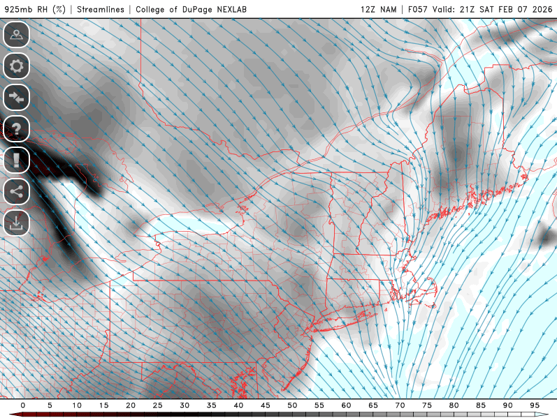
That's some really good convergence which develops through the day across eastern Mass. I'm curious to see what the HREF has for precip...I would not be shocked if QPF is going to be understated where synoptically it looks best for prolonged and heavier snows.