weatherwiz
-
Posts
81,132 -
Joined
-
Last visited
Content Type
Profiles
Blogs
Forums
American Weather
Media Demo
Store
Gallery
Everything posted by weatherwiz
-

“Cory’s in NYC! Let’s HECS!” Feb. 22-24 Disco
weatherwiz replied to TheSnowman's topic in New England
Delicious...mouth watering -
“Cory’s in NYC! Let’s HECS!” Feb. 22-24 Disco
weatherwiz replied to TheSnowman's topic in New England
I do hate how intense the low gets and if it does occlude too quickly. What could happen in this case is there will be screw zones but its really impossible to know where those would be and how bad they would be. Like even on my map I am fully expecting there will be areas which probably barely get to the low amount of my ranges. Confidence is much highest NE CT into NE MA in meeting or exceeding forecast -
“Cory’s in NYC! Let’s HECS!” Feb. 22-24 Disco
weatherwiz replied to TheSnowman's topic in New England
In the past I’d be a bit concerned with the euro but given how bad it’s been and being kind of alone…not putting much weight on it. But watch it bite me in the weenie -
“Cory’s in NYC! Let’s HECS!” Feb. 22-24 Disco
weatherwiz replied to TheSnowman's topic in New England
LET'S FREAKING GOOOOOO!!! https://weatherwiz.blogspot.com/2026/02/southern-new-england-blizzard-of-2026.html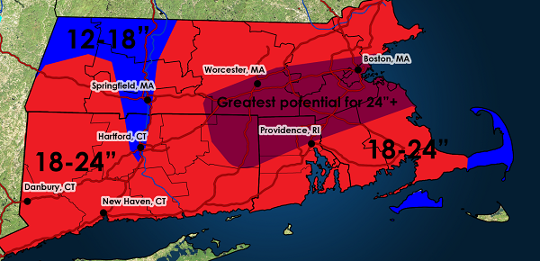
-
“Cory’s in NYC! Let’s HECS!” Feb. 22-24 Disco
weatherwiz replied to TheSnowman's topic in New England
He just posted it! -
“Cory’s in NYC! Let’s HECS!” Feb. 22-24 Disco
weatherwiz replied to TheSnowman's topic in New England
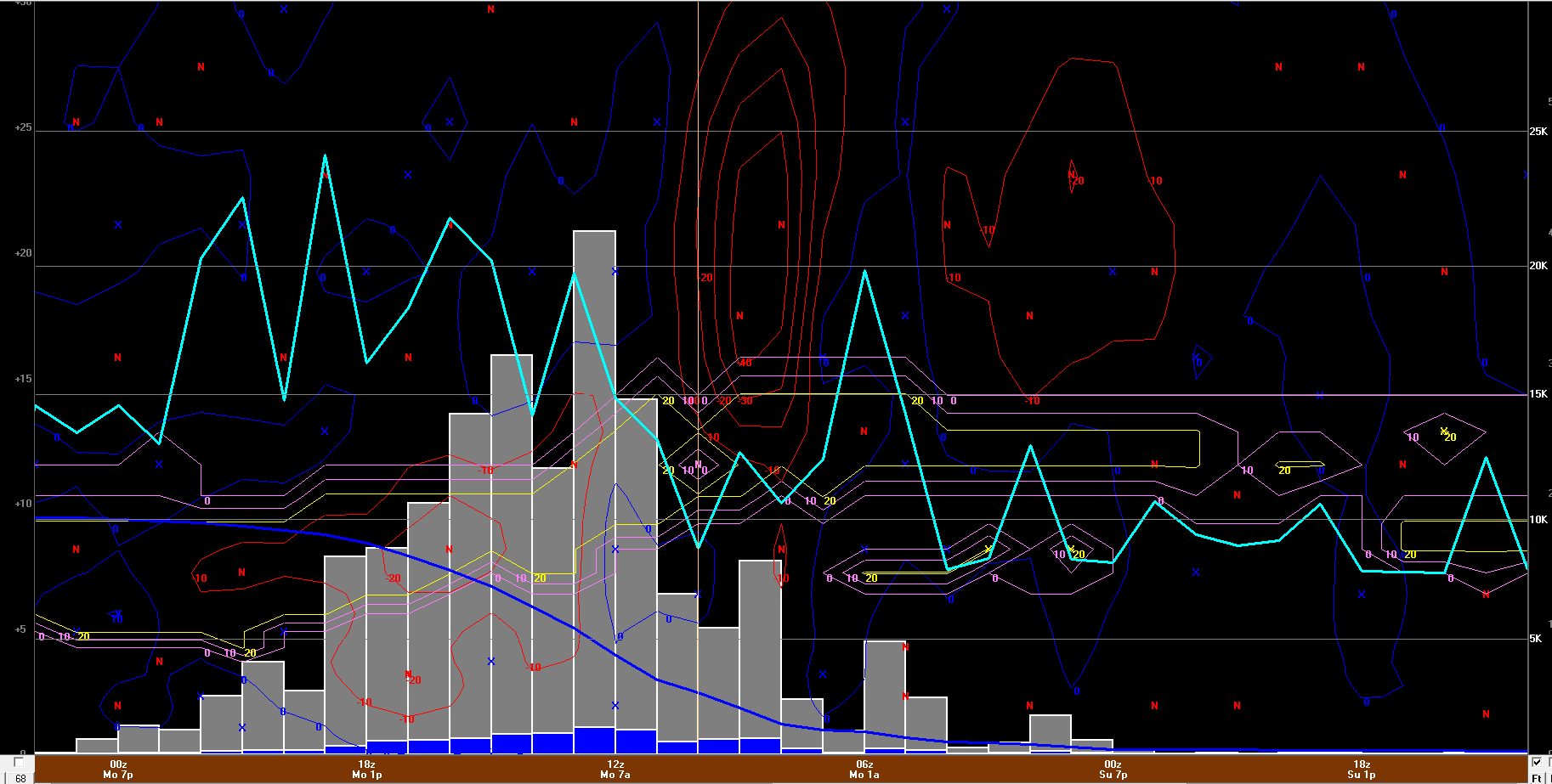
Bufkit is absolutely insane...absolutely freaking nuts. Literally several hours of snowfall rates of 2-3-4 inches per hour. BOS from GFS
-
“Cory’s in NYC! Let’s HECS!” Feb. 22-24 Disco
weatherwiz replied to TheSnowman's topic in New England
Hold me and squeeze me
-
“Cory’s in NYC! Let’s HECS!” Feb. 22-24 Disco
weatherwiz replied to TheSnowman's topic in New England
I'm really digging your YouTube videos. By far and away the best out there -
“Cory’s in NYC! Let’s HECS!” Feb. 22-24 Disco
weatherwiz replied to TheSnowman's topic in New England
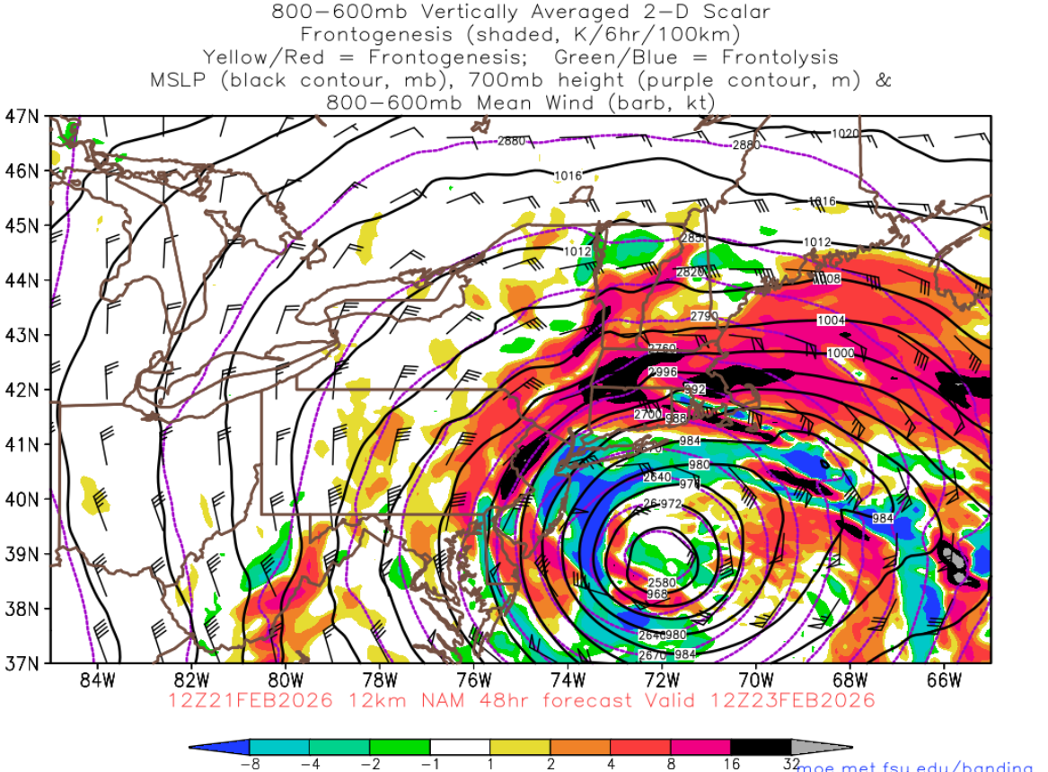
This is just insane. 509 dm in the center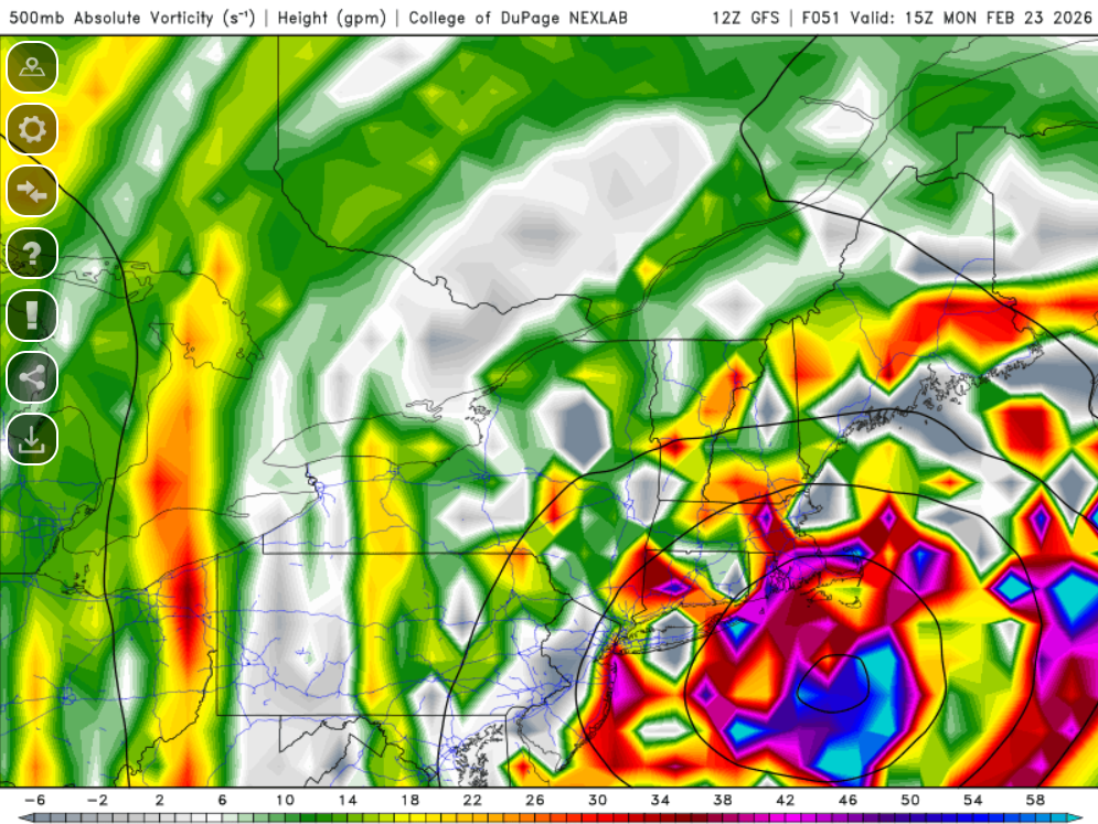
-
“Cory’s in NYC! Let’s HECS!” Feb. 22-24 Disco
weatherwiz replied to TheSnowman's topic in New England
Yup...I can't wait to draw a 2' area on my map. Have to break out the special paint brush for that -
“Cory’s in NYC! Let’s HECS!” Feb. 22-24 Disco
weatherwiz replied to TheSnowman's topic in New England
I would not be totally shocked if the QPF is even a bit underdone...at least wherever the CCB setsup and especially if this ends up being a scenario where that ends up pivoting. -
“Cory’s in NYC! Let’s HECS!” Feb. 22-24 Disco
weatherwiz replied to TheSnowman's topic in New England
You've been very spot on in all your analysis and assessments and with projected trends. Excellent stuff as always -
“Cory’s in NYC! Let’s HECS!” Feb. 22-24 Disco
weatherwiz replied to TheSnowman's topic in New England
I think someone could certainly see 3' -
“Cory’s in NYC! Let’s HECS!” Feb. 22-24 Disco
weatherwiz replied to TheSnowman's topic in New England
there may be a bit of a CT Valley screw zone and unfortunately I would be in that spot. Down into CT it may not be as terrible. -
“Cory’s in NYC! Let’s HECS!” Feb. 22-24 Disco
weatherwiz replied to TheSnowman's topic in New England
Yup...waiting on GFS. I may even hold off on the Euro but its game on. -
“Cory’s in NYC! Let’s HECS!” Feb. 22-24 Disco
weatherwiz replied to TheSnowman's topic in New England
I can't wait to make a snow map later. It's going to be like a rated R Picasso piece. -
“Cory’s in NYC! Let’s HECS!” Feb. 22-24 Disco
weatherwiz replied to TheSnowman's topic in New England
Big time wind damage across SE MA and the Cape, coastal RI, and far SE coastal CT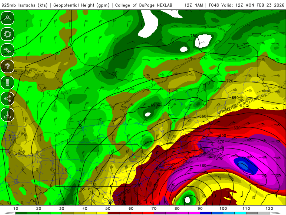
-
“Cory’s in NYC! Let’s HECS!” Feb. 22-24 Disco
weatherwiz replied to TheSnowman's topic in New England
NAM going nuclear...holy shit. it's happening -
“Cory’s in NYC! Let’s HECS!” Feb. 22-24 Disco
weatherwiz replied to TheSnowman's topic in New England
Even though its the extended HRRR it has to be encouraging to see this right lol. It's in line with other guidance so that has to offer some increased confidence in the HRRR -
“Cory’s in NYC! Let’s HECS!” Feb. 22-24 Disco
weatherwiz replied to TheSnowman's topic in New England
It's absolutely insane holy shit -
“Cory’s in NYC! Let’s HECS!” Feb. 22-24 Disco
weatherwiz replied to TheSnowman's topic in New England
Going to be a fun day of model analyzing Probably put together a map/discussion after 12z. -
“Cory’s in NYC! Let’s HECS!” Feb. 22-24 Disco
weatherwiz replied to TheSnowman's topic in New England
This is pushing historic territory -
“Cory’s in NYC! Let’s HECS!” Feb. 22-24 Disco
weatherwiz replied to TheSnowman's topic in New England
There is going to be some major power outage concerns along the south coast. -
“Cory’s in NYC! Let’s HECS!” Feb. 22-24 Disco
weatherwiz replied to TheSnowman's topic in New England
Think 18z GFS is going to be phasing in lots of energy here. that is some potent energy just rounding the backside into this. -
“Cory’s in NYC! Let’s HECS!” Feb. 22-24 Disco
weatherwiz replied to TheSnowman's topic in New England
Good point