weatherwiz
-
Posts
79,820 -
Joined
-
Last visited
Content Type
Profiles
Blogs
Forums
American Weather
Media Demo
Store
Gallery
Everything posted by weatherwiz
-
certainly eye opening in terms of shear. Lots of other issues/flags though. Enough to probably prevent widespread cells but that just means there's more environment for discrete cells to work with.
-
The timing of the front REALLY sucks Sunday but if we can develop discrete cells Sunday afternoon (mid-to-late afternoon) there is a good combo if shear/instability.
-
cell coming up to my west!!!
-
gotta be dropping maybe 1.25'' hail. That is a nasty cell
-
Could be dicey there
-
Should be good there. Try and find a great viewing spot looking west!
-
This stuff going to take off moving across central Mass and northern CT
-
I don't think that is the case. It is very unstable just ahead of the boundary and the storm inflow is not coming from the more stable air. With weak forcing and only marginal shear, storms will be pulse type. You may see more organization with that stuff to the west.
-
Sunday though not sure about. The timing of everything really sucks for here, however, there is some room for a rouge supercell or two (probably western Mass into southern VT/NH) Sunday afternoon.
-
My desk at home working I was off last week and the week prior haha. I am not sure if I will go out after, the timing will coincide with traffic but I do plan on going out tomorrow and Sunday.
-
PWATS are 1.8 to 1.9 inches so certainly going to see some localized flash flooding, especially if you see the same areas get whacked. Storm motions should also be on the slower side as well. Will probably see some localized damaging wind gusts but generally should mainly be in the 40 mph range. Hail may be tough to come by, despite the decent hail CAPE, due to warm mlvl temps and weak lapse rates.
-
I am really curious to see what happens from the Mass Pike into northern Connecticut later this afternoon. Mesoanalysis is showing 25-30 knots of bulk shear with 30-35+ knots across southeast New Hampshire (right around the vicinity of the boundary). Now mlvl lapse rates aren't as good today and there is capping to contend with but there could be numerous storms along that boundary today. Flash flooding risk may be a bit elevated.
-
Yeah it's pretty wild how much the high minimums are really pumping up the departures. I wish this got referenced more and was a focus locally when you hear climate change being discussed but for some reason it is totally overlooked. In terms of extreme heat (high temperatures) you have to think at some point we may experience that. However, because where we are located geographically compared to the westerlies, it would take one heck of a upper/lower level pattern for it to happen. There are just so many factors which influence the moderation of airmasses as they move across the country. It's like with Elevated Mixed-Layers. They're so difficult to maintain integrity into our region because there is just so much room for airmass moderation and for the integrity of EMLs to become compromised.
-
Definitely, if we end up with a llvl flow which is predominately southwesterly (which of course is quite common for us during the Summer) we are going to be in for stretches of oppressively high dewpoints. I would have to think that perhaps the largest contributor to the high dews we're seeing right now is due to how historically warm the Gulf of Mexico is for this early in the season. The only true relief we're going to get from the oppressive dews is just going to be from fronts moving through and who knows how the pattern sets up moving forward. We could very easily find ourselves in a pattern where FROPAs are few and far between and very weak. So dews go from 70's to upper 60's lol.
-
I finally did get around to painting the steps haha. But in all seriousness...I do get nervous with the trees. This is a older house and I think needs a bit of work but we plan on moving (hopefully soon).
-
I'm hoping at some point this summer we get a derecho to take down the trees in front of the house and some of the neighbors trees. The front yard faces west and I don't get good views because of the trees. Hard to take video of lightning and pics of shelfs with trees in the way. Take em down Mother Nature.
-
Can we maybe call it a dewpoint front But yeah whatever the boundary is it isn't well defined and not particularly uniform. I wonder if it may even wash out some as we crank the mixing and heating?
-
We know what that means
-
Next week reminds me of like mid July or August. Have a cold front moving across the country with little relief behind the front lol...the cool air stays across the International border lol
-
I have not taken a look yet, but I am not surprised. I was liking the look of 12z models but as Scott said, the timing needs to be worked on.
-
some nice flashes of lightning!
-
Very gusty here
-
wonder if you'll get hail. I bet you see hail in like 30 seconds
-
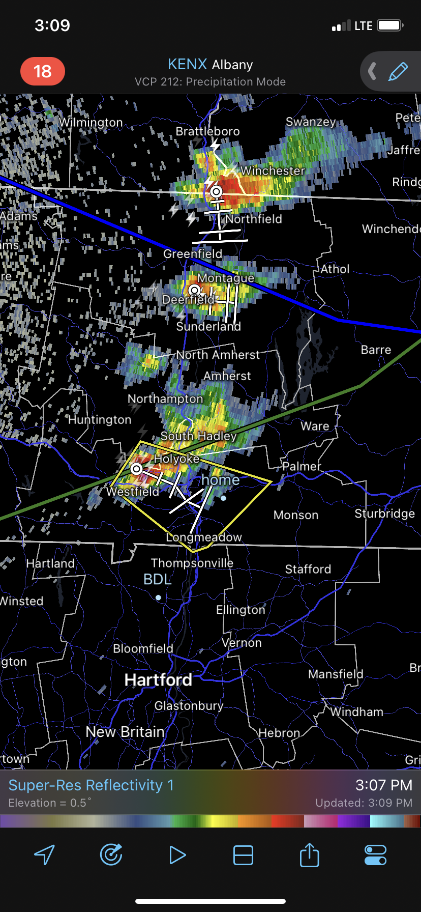
Nice hail core over Westfield. This is such BS. Take two weeks off work to storm chase and we get NOTHING...go back to work this week and all hell breaks loose. I'm going outside, closing the windows in my car, and putting the heat on full blast so when I leave to go home I just bake in the car. This is absolutely ridiculous. Every freaking time. Total freaking crap.
-
I knew this was going to happen ughhh