weatherwiz
-
Posts
79,820 -
Joined
-
Last visited
Content Type
Profiles
Blogs
Forums
American Weather
Media Demo
Store
Gallery
Everything posted by weatherwiz
-
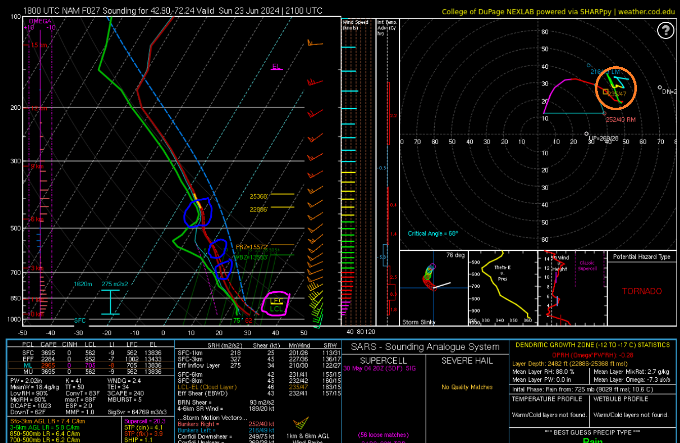
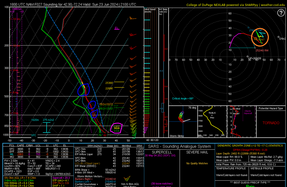
Sticking with EML's, the reason why they can contribute to widespread, high-end severe weather is they keep the atmosphere capped which prevents cumulus and storms from developing too early. Even if the convective temperature is reached, you'll often need very strong lift to break the cap. So, what this does is allow for extreme instability to develop at the sfc. When the cap breaks, parcels then violently accelerate upwards and because of the steep lapse rates (decrease of temperature with height) in the 700-500mb layer, parcels will continue to rapidly accelerate well into the upper troposphere. This results in rapidly strengthen thunderstorms which can quickly become severe. With the absence of an EML for tomorrow, below is a forecast sounding from the 18z NAM within southwest New Hampshire which I will illustrate a few things: 1. This is a very good shear profile, as evident by the hodograph in the upper right. You have speed shear present, especially in the lowest 3km and you have directional shear present, both in the lowest 3km and especially the lowest 3km. However, note the messy look of the hodograph (circled in orange). This is indicative of a veer-back-veer wind profile which is present in the 700mb to about 450mb level. This is something which can be critical to the potential for tornado outbreaks in the Plains. While this look DOES NOT inhibit tornado potential, it can negate the potential for multiple or several tornadoes. Sometimes, "busts" in the Plains are the result of veer-back-veer wind profiles. 2. With the lack of an EML, mid-level lapse rates are on the weak side. They aren't terrible, forecast to be around 6-6.5C/KM, but what is hurting the lapse rates are these subtle warm layers (circled in blue) and a evident cap just above 500mb. What does this mean? As mentioned above, what steep lapse rates do is enhance upward parcel acceleration. When parcels are able to rapidly accelerate upwards this can result in vigorous updrafts and powerful thunderstorms. Given the atmosphere is moderately unstable, parcels will rapidly accelerate towards the LCL and LFC (note the two are close together). So once we get the proper lift, storms will rapidly develop. As parcels continue to accelerate upwards, the parcel acceleration will slow due to these subtle warm layers and it is very possible the cap above 500mb could hinder the severity as parcels could struggle to continue accelerating. These factors, along with the lack of the EML will prevent a more widespread event from occurring. All in all, while the atmosphere will be conducive for severe weather and a few tornadoes for a good chunk of the region, the area of greatest potential is going to be much more narrow, thus this will not be a widespread, high-end event.
-
I think another factor to consider too is the difference between stronger and weaker tornadoes. Back in the 2010 setup, which had a 10% hatched area with a lack of an EML, the wording was for a few strong tornadoes (hence the hatched). Lack of EMLs don't necessarily hinder tornado potential, however, they do greatly hinder the likelihood for stronger tornadoes. Another factor to also consider is storm mode. Obviously, one attribute of EMLs is due to the strong capping, they can keep storms discrete which increases the likelihood for thunderstorms to become mature and fully utilize the environment around them. For tomorrow, if storms are able to remain on the discrete side, the environment is supportive for multiple tornadoes so I think that factors into the 10% probability.
-
Any of the local news stations really. NBC30 is usually top notch, especially when Ryan is working and covering warnings.
-
Rotation started right over west Hartford where I lived for so many years
-
We had 10% a few years back (think 2020) and again 5/15/18.
-
wagons north tomorrow. Reminds me of winter
-
I am just going to start off by saying WE ARE NOT LOOKING AT A WIDESPREAD, HIGH-END SEVERE WEATHER EVENT While we are lacking an elevated-mixed layer, it is important to note that EML's are important when seeking out the potential for a widespread, high-end severe weather event. You can still get severe weather and even numerous severe storms/damage but typically mostly everything falls short of high end. Now that we got that out of the way let's get into it. An elongated stationary boundary is currently positioned from off the New England coast across central New England, though the Great Lakes, and into the upper-Midwest. Shortwave energy within the north-central Plains and upper-Midwest is expected to amplify as it traverses the Great Lakes region resulting in strengthening low pressure at the sfc. This will help push the stationary boundary within New England northward as a warm front overnight and early Sunday morning. Thus, very warm and humid air advects northward. With the amplifying shortwave trough and strengthening sfc low, the response will be increasing shear across the Northeast and New England characterized by bulk shear values in the 40-50 knot range. These values are more than sufficient for convection to become organized and even acquire supercell characteristics. In addition, llvl winds are expected to back in the vicinity of the warm front, yielding enlarged hodographs and 0-1km helicity values 150-200+ m2s2 and 0-3km helicity values 200-250+ m2s2. These values are more than sufficient for the more mature thunderstorms to become supercells. Combination of temperatures rising into the 80's and dewpoints climbing into the lower 70's will yield a moderately unstable airmass characterized by mixed-layer CAP values in the 1500-200 J/KG range. Weak mid-level lapse rates, ~6 C/KM, will hold the atmosphere back from becoming more unstable. However, should dewpoint pooling occur, which is possible within the Connecticut River Valley, dewpoints could climb into the 74-76F range, this may yield a zone of mixed-layer CAP values in the 2000-2500 J/KG range and compensate a bit for the weaker lapse rates. Scattered-to-numerous thunderstorms should begin developing by early afternoon across NY/PA ahead of the cold front with thunderstorms developing across eastern NY and western New England by mid-afternoon ahead of the pre-frontal trough. Given the ingredients mentioned, the strongest thunderstorms will be capable of producing damaging wind gusts and hail. Should any discrete, mature cells develop, given the strong wind shear, the potential also exists for a few tornadoes. High PWATS should also yield potential for localized flash flooding.
-
Just got back from doing some errands so I can go out after but going to start a threat in a few. The thing we have to remember with steep mid-level lapse rates/EML's and severe weather is this EML's are not required for severe weather, however, they are extremely important when talking about the potential for widespread, high-end severe weather. Poor or weak mid-level lapse rates just vastly reduce the potential for widespread, high end severe weather.
-
I don't know if we will see this with the new D2 but if the trends continue, I think we will see a 10% TOR somewhere. Now, it is important to note mlvl lapse rates aren't great which is going to scale things back to some degree. But what that probably means is the threat for higher-end, widespread severe is diminished. What we need to watch for, however, is dewpoint pooling. If we can pool dewpoints to 74-76 that will compensate some for the weak lapse rates.
-
I think the 12z NAM has beefed things up for tomorrow. I may start a thread but I'm playing SNES right now
-
probably next April
-
HRRR has been pretty consistent in evolving a cluster of storms across western Mass later and tracking across northern CT. Once again bulk shear is adequate for storm organization and instability will be plenty. Localized damaging wind gusts and maybe some hail within the stronger cores but mlvl lapse rates suck.
-
Definitely a refresher for some come Monday but short-lived. Not as intense as this week.
-
I scream, you scream, we all scream for CG’s
-
Yeah tomorrow looks scattered. May have to watch for some overnight convection too. it seems like the 18z models have sped up the timing of the front a bit too. But the primary focus for convection may be a pre-frontal trough. The shear is quite impressive, both speed and directional, and instability will be plenty. Lapse rates aren’t the best but they aren’t the worst either. Right now I would favor eastern NY (up around Albany) through western Mass, southern VT, and southwest NH. There are some indicators we could see a line of supercells from which is very abnormal for around here. If we don’t see discrete we could see a decent evening/early overnight snow with the approaching shortwave and good height falls.
-
Yeah I do recall guidance like 7-10 days ago having something. The GFS anyways has done a decent job with some of the last few waves and hinting at them 7+ days out.
-
Outside of a nice swirl I thought it always looked like crap and I don’t recall any guidance doing anything with it. Don’t even recall seeing any shower or thunderstorms in GA or FL outside of some widely isolated, afternoon heating driven stuff.
-
why was that swirl off Florida/Georgia designated with moderate probabilities for development?
-
The rotation of the feature is certainly evident and noteworthy but it’s also difficult to see if it connects with the cloud base. Maybe a land spout? Or a gustnado?
-
Wow!
-
Nows there’s an area I wouldn’t want to be in
-
not sure that is rotation. might be a bit divergent
-
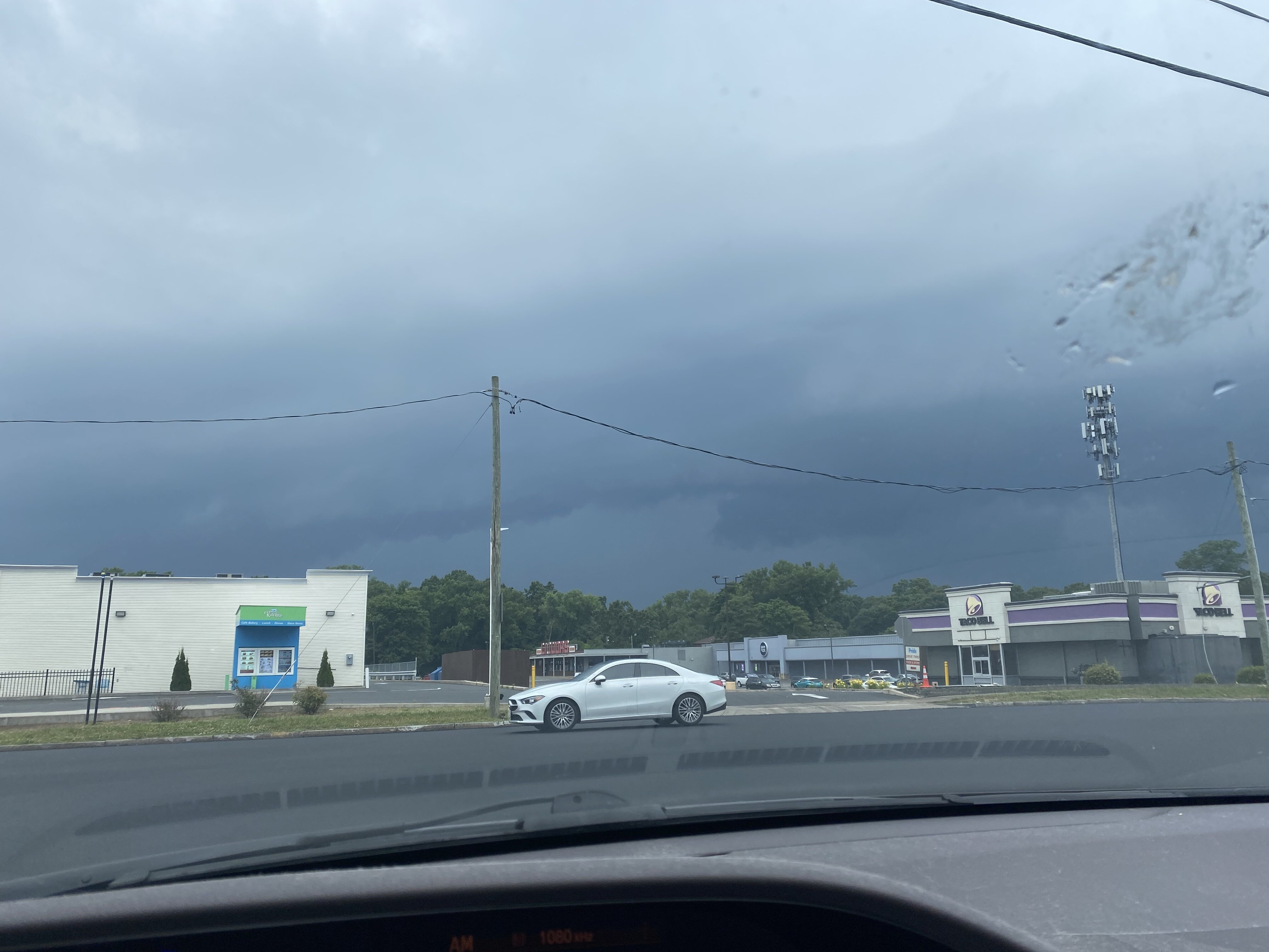
The strike was just over 1/2 mile away
-
HUGE crash of thunder!!!!