weatherwiz
-
Posts
79,820 -
Joined
-
Last visited
Content Type
Profiles
Blogs
Forums
American Weather
Media Demo
Store
Gallery
Everything posted by weatherwiz
-
maybe I'll get a great 360 view if I get sucked up in a tornado
-
Jeeze...it would take my longer to go from Walpole, NH to Laconia, NH (1h48m) then it would from Springfield, MA to Walpole, NH (1h23m).
-
That would be my luck
-
satellite looks very good off to the west there
-
Well I am probably going to go to Walpole, NH to at least start but I will most likely probably have to head northeast from there but can assess once stuff starts popping up. Probably end up near Laconia or maybe slightly east.
-
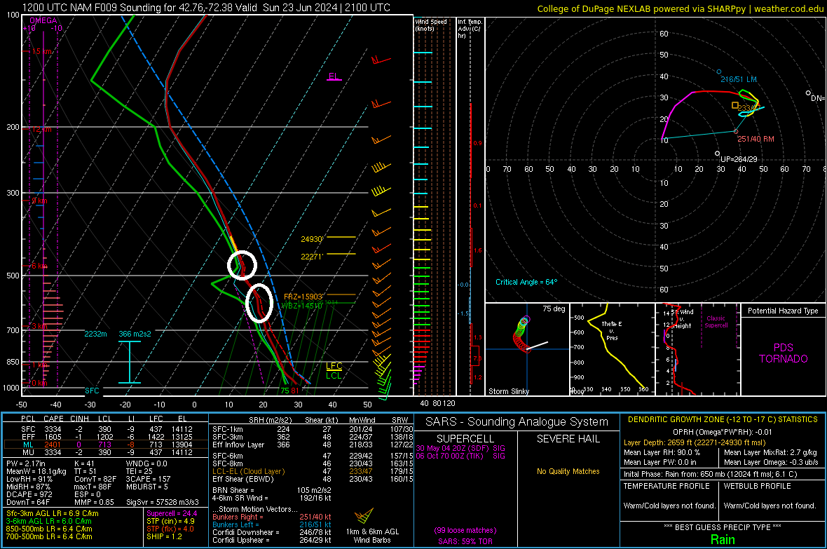
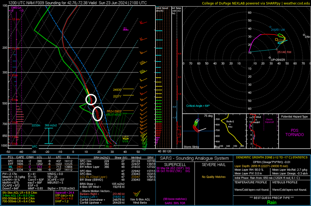
12z NAM sounding within southwest NH for 21z today. Can still see some capping. llvl shear certainly pretty strong though as is instability
-
Was just looking at the 12z balloon launches from Albany (and even Upton) and there is an evident cap in place. The better forcing and height falls during the day will be northern and central New England and that should be enough to break any capping up there. South into Mass and CT I don't think the cap breaks. Seems too strong to me and by the time it may break with that approaching shortwave the best dynamics may be lifting out. I'm not even sure if there will be much activity across Mass. But anyone in Mass and CT should definitely not let their guard down. All it takes is for one cell to get going and develop a mature enough updraft and it will have plenty to CAPE/shear to utilize. WE'll have to watch the progression of the warm front too. It seems the trend has been to lift the warm front north and east a bit more quickly.
-
I don't think there is going to be much activity but there may be a window between like 5-8 PM for activity to develop across western CT as there is some shortwave energy approaching. Showers may start popping during the afternoon but they will struggle to intensify given the capping and weak forcing.
-
Yeah chasing here sucks. You can’t even really chase. I know I call it chasing but I don’t really chase. What I just try to do is pick an area which looks to be a decent spot before hand and then look on google maps for any like open fields, golf courses, etc. in the vicinity. Then get there a few hours before hand. I always prefer northern CT being in the game because BDL is great for views. I tend though not to go after stuff as it’s ongoing. Too much traffic, if you are in areas with lots of trees blocked roads become a concern, and getting caught in the torrential downpours driving can be dicey. Difficult to see and the way people drive…always afraid of getting rear ended
-
May have to end up going a bit farther north into New Hampshire. Have to look deeper into stuff but looks like storm mode is going to be super messy. Also looking like a bit later for timing (not a bad thing).
-
Could start seeing stuff fire as early as 1-2 PM. Mostly in the 3-8 window though. Another round of isolated storms late evening and early overnight but little svr risk
-
The NAM/HRRR are spitting out some of the highest supercell/STP values I can remember here. Of course though that doesn’t mean everything, you still need mature enough storms to utilize the environment and that’s the question right now, how many can?
-
I'm noticing some of the point-and-click soundings are showing 700-500mb lapse rates around 6.5C/KM but looking at the soundings, those raw numbers don't look right. Not sure that really means anything, I would assume the raw numbers you see in the bottom left box aren't used anywhere (like in the computation of the CAPE).
-
Great post. I am a bit more uncertain as well as to how much discrete cells we will see tomorrow. I was entertaining the idea yesterday that we could see a line of supercells possibly, but I should have known that was extremely unlikely. But to the bolded...that's exactly what I think we'll end up seeing. A few cells that are able to really utilize the environment and produce. Most of the storms may struggle to end up producing. But we'll see what happens...if we get dews 73-76 like the NAM has this makes things a bit more interesting.
-
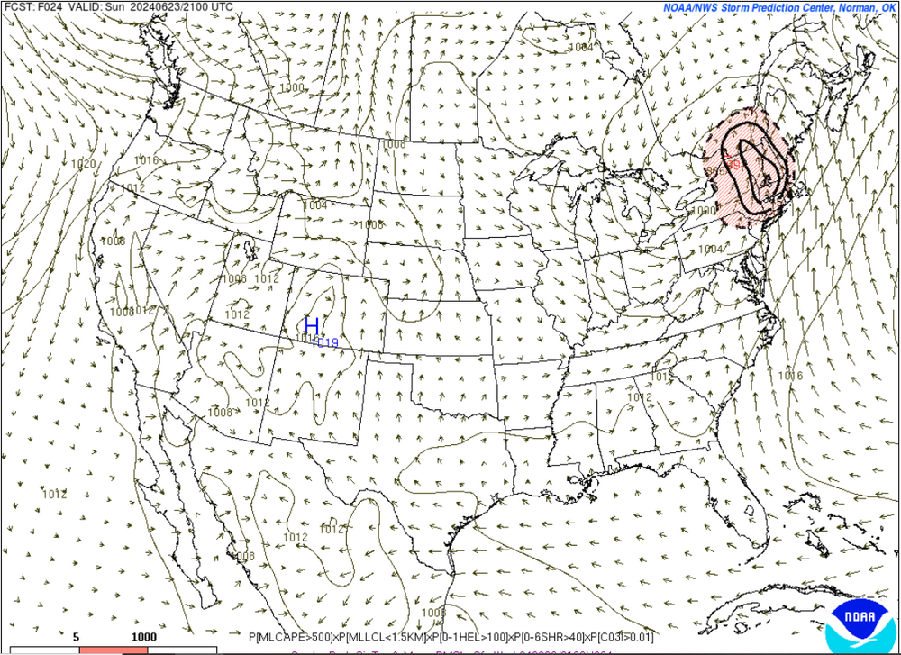
Pretty interesting to see that area highlighted...it was an area I had interest in for some of the greatest potential.
-
Agreed. Even up north though...the storm mode is going to be key in terms of tornado potential. The 0z HRRR develops alot of activity, so storm mode may get very messy and that will have an impact on updrafts and may add additional challenges for updrafts to really become mature.
-
Shear is certainly there. Definitely some messy looks. One of the several reasons we won't see widespread, high-end severe and why we'll see probably one or two concentrated swaths of some severe.
-
Wow this is a substantial increase in the 21z SPC SREF SIG TOR ingredients versus previous runs. This tends to run wild during low CAPE/high shear events so to see values this high for an environment like tomorrow is pretty wild.
-
Between like 2-7 PM for the storms ahead of the pre-frontal trough. Although could see stuff starting to fire as early as 1. There may be some storms with the actual cold front during the late evening and overnight but these may be more on the isolated side.
-
Sad…three people injured by lightning strikes at the TPC in Cromwell
-
pretty much lol
-
When Kevin switches from BDL to ORH
-
That was 6/1/2011
-
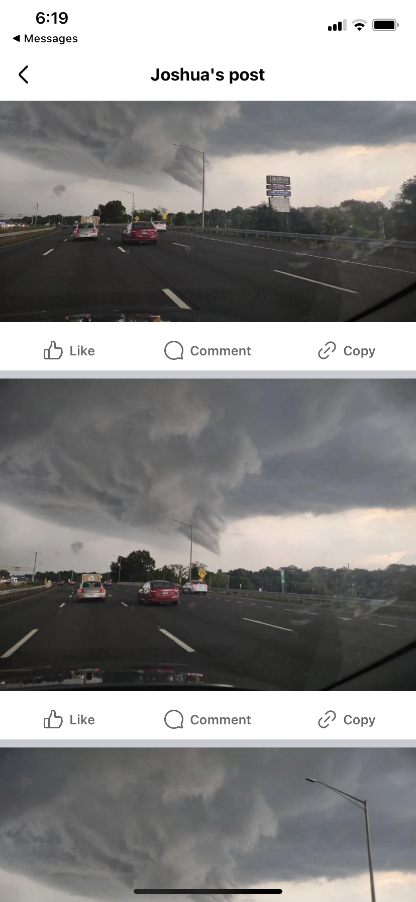
Friend of mine posted these to Facebook (gave me permission to post). Took these in Rocky Hill. Definitely looks like wall cloud or funnel cloud

-
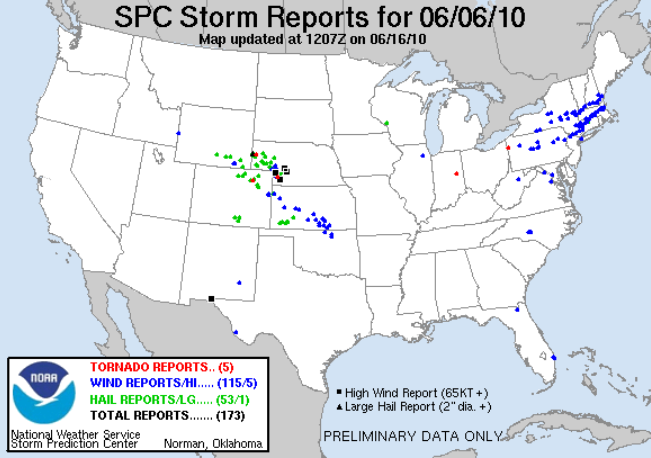
June 6, 2010 No tornadoes and two swaths of wind damage