

weatherwiz
-
Posts
80,026 -
Joined
-
Last visited
Content Type
Profiles
Blogs
Forums
American Weather
Media Demo
Store
Gallery
Everything posted by weatherwiz
-

“Cory’s in NYC! Let’s HECS!” Feb. 22-24 Disco
weatherwiz replied to TheSnowman's topic in New England
Not surprised given the increase in llvl dynamics. In fact, these totals from the NBM at this range are pretty damn impressive I think. -
“Cory’s in NYC! Let’s HECS!” Feb. 22-24 Disco
weatherwiz replied to TheSnowman's topic in New England
Ultimately, the processes involved are extremely complex. I'm sure if you have extremely sufficient snow growth production that can offset stronger winds. I don't recall what the winds aloft were that day but the winds with this will be a completely different magnitude. I also would think wind at cloud level will be much stronger than Jan 16 too. I do agree, I think the wind can get overstated at times when talking about being a hinder to ratios and snowgrowth but this would be a whole other level of magnitude that IMO winds would absolutely impact growth and ratios. -
“Cory’s in NYC! Let’s HECS!” Feb. 22-24 Disco
weatherwiz replied to TheSnowman's topic in New England
May be one of the most impressive MAULS I've seen here -
“Cory’s in NYC! Let’s HECS!” Feb. 22-24 Disco
weatherwiz replied to TheSnowman's topic in New England
The Sierras are much higher up in elevation. Less downward travel of the precip -
“Cory’s in NYC! Let’s HECS!” Feb. 22-24 Disco
weatherwiz replied to TheSnowman's topic in New England
Ratios in this would probably be at best 12:1 or so...maybe you can get 15:1 under the banding but that is going to be tough with the wind. -
“Cory’s in NYC! Let’s HECS!” Feb. 22-24 Disco
weatherwiz replied to TheSnowman's topic in New England
This looks a little fun -
“Cory’s in NYC! Let’s HECS!” Feb. 22-24 Disco
weatherwiz replied to TheSnowman's topic in New England
Was just looking at 700mb RH but it's not necessarily dry air on a better look...RH is still like 85-90%. I thought it was lower. But I have no complaints with the NAM...love where we sit on it. I would maybe like to see it occlude a bit farther north though, especially since it seems to really crawl. That would end up nailing with with a CCB but may also assist in pushing it farther north instead of sitting and then pivoting through? idk...kind of minute to worry about now but just a thought -
“Cory’s in NYC! Let’s HECS!” Feb. 22-24 Disco
weatherwiz replied to TheSnowman's topic in New England
Actually looks like the NAM is wrapping in some dry air -
“Cory’s in NYC! Let’s HECS!” Feb. 22-24 Disco
weatherwiz replied to TheSnowman's topic in New England
Let's Blizzicane it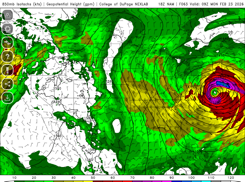
-
“Cory’s in NYC! Let’s HECS!” Feb. 22-24 Disco
weatherwiz replied to TheSnowman's topic in New England
The NAM is going to go absolutely nuclear. Can see that happening at 60 -
“Cory’s in NYC! Let’s HECS!” Feb. 22-24 Disco
weatherwiz replied to TheSnowman's topic in New England
Definitely encouraged by the Euro. Would like to see it get tugged a bit more but overall (for western peeps to get into the best goods too)...for where we stand time wise that is definitely doable. No complaints on this run either though. Keep it going tonight please -
“Cory’s in NYC! Let’s HECS!” Feb. 22-24 Disco
weatherwiz replied to TheSnowman's topic in New England
BOX rolling out some watches -
These snowflakes are absolutely MASSIVE
-
“Cory’s in NYC! Let’s HECS!” Feb. 22-24 Disco
weatherwiz replied to TheSnowman's topic in New England
As long as we melt by April 30 -
“Cory’s in NYC! Let’s HECS!” Feb. 22-24 Disco
weatherwiz replied to TheSnowman's topic in New England
Think I need around 65" to hit 100. Hoping to get that down to around 62" today and then around 40" Sunday into Monday, maybe get that down to 25" end of week then finish off the rest in March and early April if needed -
Well after the brief pulse up then pulse down its been ripping very good and even beginning to stick. Time to re-freshen the pack a little bit and then add another 1 to 2 feet Sunday night
-
“Cory’s in NYC! Let’s HECS!” Feb. 22-24 Disco
weatherwiz replied to TheSnowman's topic in New England
GEFS looks pretty damn good. -
and it just shut down as quickly as it ramped up
-
snow coming down pretty good here! intensified pretty quickly.
-
snow has started!
-
“Cory’s in NYC! Let’s HECS!” Feb. 22-24 Disco
weatherwiz replied to TheSnowman's topic in New England
I am not so sure I would classify this as a tick southeast. Obviously, looking at this face value that's the take, HOWEVER, that is also tied into where the GFS believes the brunt of the CCB will traverse and impact. So in this regard, the QPF isn't necessarily reflective of trends in storm track but trends in CCB (which we know models don't do great with until ~24hr or just inside). BUT...this does provide a very good proxy of what you can probably expect for max QPF -
“Cory’s in NYC! Let’s HECS!” Feb. 22-24 Disco
weatherwiz replied to TheSnowman's topic in New England
Yeah he's been quite spot on with diagnosing the trends and how things may evolve so I definitely think there is some additional room too but being cautious on the extent -
“Cory’s in NYC! Let’s HECS!” Feb. 22-24 Disco
weatherwiz replied to TheSnowman's topic in New England
Absolutely nothing to complain about on that GFS run. Just have to hope we see a bump in that direction from the Euro too. You have to wonder though if this is the far western edge of the envelope of if there is some additional room for a bit N and W, if this is the western envelope I'd def be a little concern for those shuffles which of course wouldn't be good for western folk -
“Cory’s in NYC! Let’s HECS!” Feb. 22-24 Disco
weatherwiz replied to TheSnowman's topic in New England
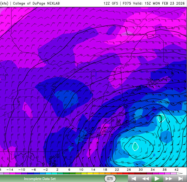
That is some serious dynamic cooling going on too. This LLJ is absolutely insane...imagine the moisture being tossed into this and look at those temps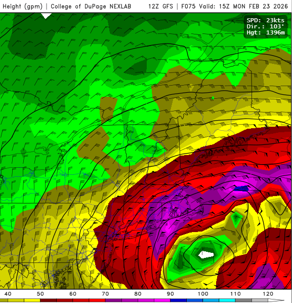
-
“Cory’s in NYC! Let’s HECS!” Feb. 22-24 Disco
weatherwiz replied to TheSnowman's topic in New England
IDK...this looks pretty damn good to me with getting heavy banding across much of the region. That 700mb low development and track is pretty solid. Maybe not perfect but strengthening just to our south with a bit of ENE movement.


