weatherwiz
-
Posts
80,203 -
Joined
-
Last visited
Content Type
Profiles
Blogs
Forums
American Weather
Media Demo
Store
Gallery
Everything posted by weatherwiz
-

"Don’t do it" 2026 Blizzard obs, updates and pictures.
weatherwiz replied to Ginx snewx's topic in New England
One good thing about these high wind events is you don't have to clean off the car. It's underrated how much having to clean off the car adds to cleaning up the driveway, especially in the area of the car and if you have multiple cars next to each other -
"Don’t do it" 2026 Blizzard obs, updates and pictures.
weatherwiz replied to Ginx snewx's topic in New England
It's delivering here pretty good! -
"Don’t do it" 2026 Blizzard obs, updates and pictures.
weatherwiz replied to Ginx snewx's topic in New England
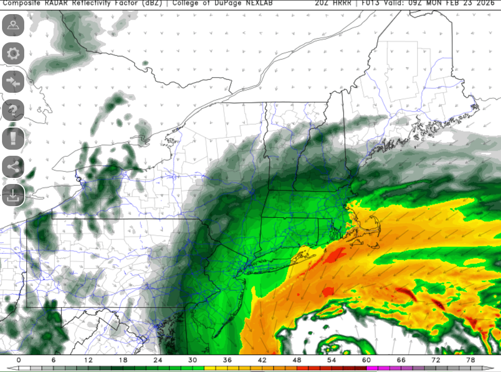
Its still going to be good. As dendrite mentioned the east band will start stealing the show but the western band should still hold decent rates and I would not be surprised seeing some fill in a bit, especially as that western fronto also collapses some. Think coastalwx said it but that should rot basically through noon and even the newer HRRR runs are hinting at it -
"Don’t do it" 2026 Blizzard obs, updates and pictures.
weatherwiz replied to Ginx snewx's topic in New England
unfortunately it looks like the sfc low is starting to tug a bit more east -
"Don’t do it" 2026 Blizzard obs, updates and pictures.
weatherwiz replied to Ginx snewx's topic in New England
looks like thundernsow in NYC -
"Don’t do it" 2026 Blizzard obs, updates and pictures.
weatherwiz replied to Ginx snewx's topic in New England
Definitely going to be some >2ft totals although good luck to those measuring -
"Don’t do it" 2026 Blizzard obs, updates and pictures.
weatherwiz replied to Ginx snewx's topic in New England
Highly doubt the band is going to shut down as quickly as guidance was indicating yesterday. Also got some blossoming there just north of the low...feel like I'm tracking a cane
-
"Don’t do it" 2026 Blizzard obs, updates and pictures.
weatherwiz replied to Ginx snewx's topic in New England
be interesting to see if power outages across CT start creeping up. been rather steady ~4k -
"Don’t do it" 2026 Blizzard obs, updates and pictures.
weatherwiz replied to Ginx snewx's topic in New England
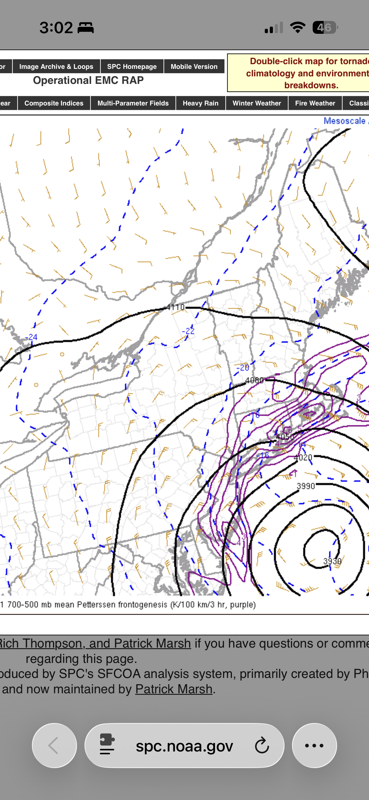
If you follow where H7 should track that bodes extremely well to get this band to pivot across a great deal of SNE...especially back to at least the CT River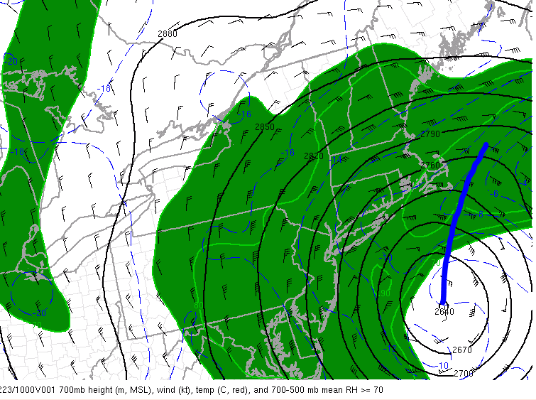
-
"Don’t do it" 2026 Blizzard obs, updates and pictures.
weatherwiz replied to Ginx snewx's topic in New England
some gravity waves south of Long Island looks like -
"Don’t do it" 2026 Blizzard obs, updates and pictures.
weatherwiz replied to Ginx snewx's topic in New England
Yup! -
"Don’t do it" 2026 Blizzard obs, updates and pictures.
weatherwiz replied to Ginx snewx's topic in New England
I wouldn't be shocked if the two bands converge actually -
"Don’t do it" 2026 Blizzard obs, updates and pictures.
weatherwiz replied to Ginx snewx's topic in New England
LET'S GO!! -
"Don’t do it" 2026 Blizzard obs, updates and pictures.
weatherwiz replied to Ginx snewx's topic in New England
102K w/o power in NJ -
"Don’t do it" 2026 Blizzard obs, updates and pictures.
weatherwiz replied to Ginx snewx's topic in New England
winds starting to pick up here and howl a bit -
"Don’t do it" 2026 Blizzard obs, updates and pictures.
weatherwiz replied to Ginx snewx's topic in New England
Let's go, let's bring it!! Up and ready, coffee made. Pound town time -
"Don’t do it" 2026 Blizzard obs, updates and pictures.
weatherwiz replied to Ginx snewx's topic in New England
Waking up nude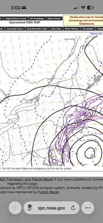
-
“Cory’s in NYC! Let’s HECS!” Feb. 22-24 Disco
weatherwiz replied to TheSnowman's topic in New England
Time to get some sleep. Aiming to wake up 2-3 AM or maybe a bit after 1. Gotta recharge a bit -
“Cory’s in NYC! Let’s HECS!” Feb. 22-24 Disco
weatherwiz replied to TheSnowman's topic in New England
Looking at upper level water vapor and mesoanalysis...I think I would be a bit shocked if slides east. In fact, I think this will end up tracking somewhat close to what some guidance was showing 0z/12z yesterday...maybe not quite to the extent but I think some of the east jogs we saw today are overstated -
“Cory’s in NYC! Let’s HECS!” Feb. 22-24 Disco
weatherwiz replied to TheSnowman's topic in New England
So fun to watch
-
“Cory’s in NYC! Let’s HECS!” Feb. 22-24 Disco
weatherwiz replied to TheSnowman's topic in New England
No, they are sometimes issued for wildfires, child abductions, a hazardous spill, etc. -
“Cory’s in NYC! Let’s HECS!” Feb. 22-24 Disco
weatherwiz replied to TheSnowman's topic in New England
very well could be -
“Cory’s in NYC! Let’s HECS!” Feb. 22-24 Disco
weatherwiz replied to TheSnowman's topic in New England
Lets go!!! This is all new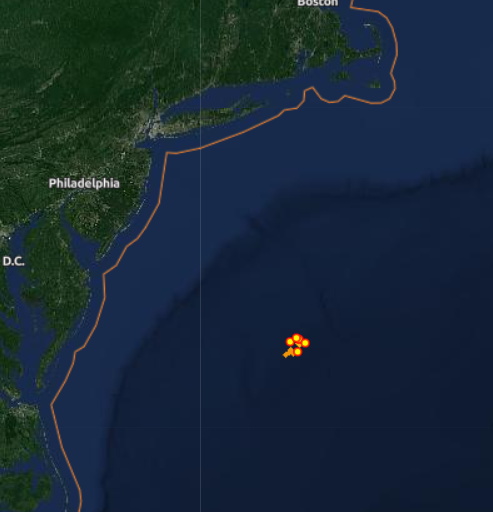
-
“Cory’s in NYC! Let’s HECS!” Feb. 22-24 Disco
weatherwiz replied to TheSnowman's topic in New England
Here's a good visual and this is probably one of the more impressive MAULs you usually see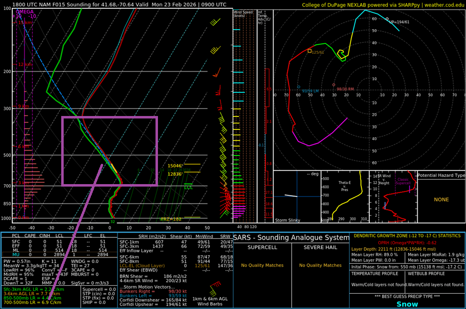
-
“Cory’s in NYC! Let’s HECS!” Feb. 22-24 Disco
weatherwiz replied to TheSnowman's topic in New England
Widespread heavy snow overspreads everyone through the night. Uniform ~30dbz across the state. HRRR also looks to hold onto the snow/banding longer before breaking down than NAM/GFS. Been pretty consistent too with widespread 40-50 mph gusts