Ralph Wiggum
-
Posts
17,383 -
Joined
-
Last visited
Content Type
Profiles
Blogs
Forums
American Weather
Media Demo
Store
Gallery
Everything posted by Ralph Wiggum
-

January 25-26 Winter Storm Potential
Ralph Wiggum replied to Ralph Wiggum's topic in Philadelphia Region
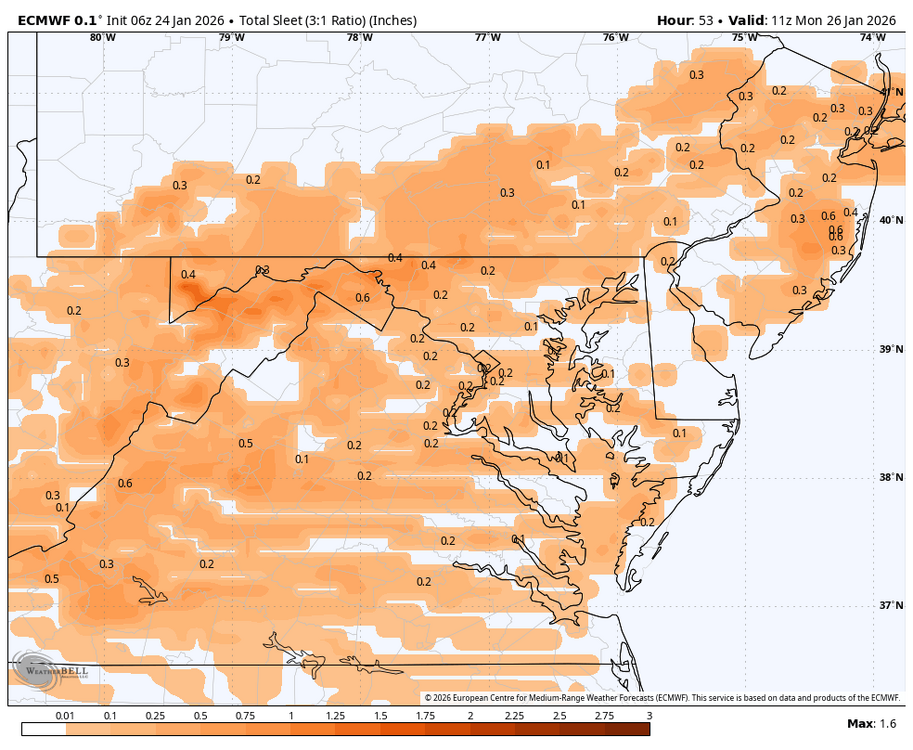
Iirc I got 3" sleet down in Upper Darby when I lived there -
January 25-26 Winter Storm Potential
Ralph Wiggum replied to Ralph Wiggum's topic in Philadelphia Region
Yet some never learn the NAM excels at seeing the warm tongue before other guidance and go into denial when it leads the way -
January 25-26 Winter Storm Potential
Ralph Wiggum replied to Ralph Wiggum's topic in Philadelphia Region
This almost mirrors my FB call. Great minds think alike. Ppl that follow 2 days ago were asking why they should trust me regarding the changeover because the news isnt mentioning. Nobody is forced to trust anyone. The TV news is there for ratings and most FB 'forecasters' are there for clicks. I dont even know what clicks are nor how to make a profit nor do I care to. I put out calls as a service, but more for myself so I can go back and grade it after a storm. Anyway, good luck. I have my area at 4-7" before the flip. -
January 25-26 Winter Storm Potential
Ralph Wiggum replied to Ralph Wiggum's topic in Philadelphia Region
I feel we are headed that way unfortunately. Bigger story with this will be the icing/sleet and not the snow. -
January 25-26 Winter Storm Potential
Ralph Wiggum replied to Ralph Wiggum's topic in Philadelphia Region
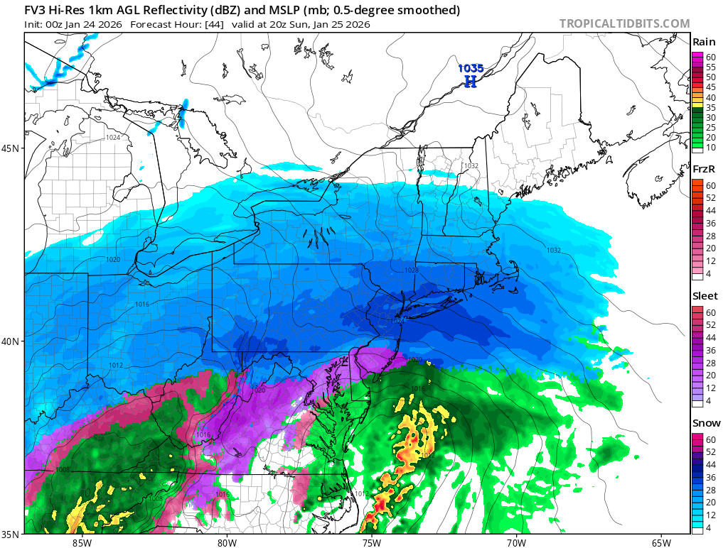
FV3 ticked N with the mixing. A little less white a little more ice. Scary thing is there is still 24 hrs to go this could continue to trend worse. This is turning into a major ice situation for SE PA now? -
January 25-26 Winter Storm Potential
Ralph Wiggum replied to Ralph Wiggum's topic in Philadelphia Region
NAM says mix line might get to NY border. Keeps plowing N. Writing is on the wall with this one. Mainly a sLeet/icing event much of SE PA after a 4-hr thump. -
January 25-26 Winter Storm Potential
Ralph Wiggum replied to Ralph Wiggum's topic in Philadelphia Region
6" is reasonable for our location. Seeing alot of posts here and FB on how we won't see less than 12" because this is a 16 hr storm. People are forgetting only about 4-5 hours of it is actually clean snow for our areas (7am-noon?). Past 12 hrs the trend now is a quicker flip as the warm tongue screams N and W. Just hoping this isnt it and 2 weeks of cold/dry -> spring. -
January 25-26 Winter Storm Potential
Ralph Wiggum replied to Ralph Wiggum's topic in Philadelphia Region
-
January 25-26 Winter Storm Potential
Ralph Wiggum replied to Ralph Wiggum's topic in Philadelphia Region
6z euro caved with mixing up to i80. Thinking 4-8" here is a good bet topped with sleet. -
January 25-26 Winter Storm Potential
Ralph Wiggum replied to Ralph Wiggum's topic in Philadelphia Region
Finally. Mix up into the LV. -
January 25-26 Winter Storm Potential
Ralph Wiggum replied to Ralph Wiggum's topic in Philadelphia Region
Initial thump colder and heavier precip -
January 25-26 Winter Storm Potential
Ralph Wiggum replied to Ralph Wiggum's topic in Philadelphia Region
CMC much colder. Big thumper -
January 25-26 Winter Storm Potential
Ralph Wiggum replied to Ralph Wiggum's topic in Philadelphia Region
Watch, the gfs at the last minute will blast the sleet line farther north than any other guidance. It would be typical of this model. -
January 25-26 Winter Storm Potential
Ralph Wiggum replied to Ralph Wiggum's topic in Philadelphia Region
Changeover up here looks to happen between 1 and 3PM Sunday. Roughly 5-7" on the ground prior to any change. -
January 25-26 Winter Storm Potential
Ralph Wiggum replied to Ralph Wiggum's topic in Philadelphia Region
About 4" in Warminster fwiw -
January 25-26 Winter Storm Potential
Ralph Wiggum replied to Ralph Wiggum's topic in Philadelphia Region
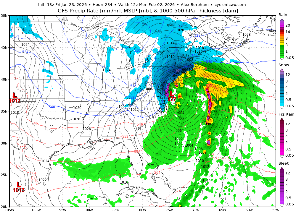
If it makes you feel better, here's the most biased cold model the fv3, often wrong, seldom right. A big hit!
-
January 25-26 Winter Storm Potential
Ralph Wiggum replied to Ralph Wiggum's topic in Philadelphia Region
2007 will be put to shame in many areas. -
January 25-26 Winter Storm Potential
Ralph Wiggum replied to Ralph Wiggum's topic in Philadelphia Region
You get the idea. Dont be so literal. -
January 25-26 Winter Storm Potential
Ralph Wiggum replied to Ralph Wiggum's topic in Philadelphia Region
Its over south of i78. Avg 4-6 nickel and dimer....though the sleet will make it seem like a MECS -
Jan 24-26 Weekend Snow and Sleetfest Model Thread Part Tres
Ralph Wiggum replied to H2O's topic in Mid Atlantic
Is this even a question? If Vegas had odds most of us would be rich. -
I'll accept it
-
Never gets above freezing thru 384 and no letup in sight. Amazing run of winter weather. We will be referring back to this one for a long long time. Savor every second.
-
Yes and yes. Signal and tellies are there.
-
If that fucker stacks vertically, thermals won't be an issue.
-
E PA/NJ/DE Winter 2025-26 Obs/Discussion
Ralph Wiggum replied to LVblizzard's topic in Philadelphia Region
Meh. OK but seriously LFG!!! Who else is ready for another week of tracking??