

Ralph Wiggum
-
Posts
17,384 -
Joined
-
Last visited
Content Type
Profiles
Blogs
Forums
American Weather
Media Demo
Store
Gallery
Everything posted by Ralph Wiggum
-

E PA/NJ/DE Winter 2025-26 Obs/Discussion
Ralph Wiggum replied to LVblizzard's topic in Philadelphia Region
Meh. OK but seriously LFG!!! Who else is ready for another week of tracking??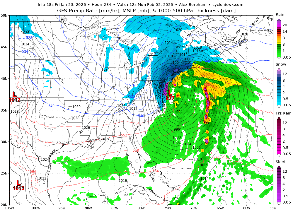
-
January 25-26 Winter Storm Potential
Ralph Wiggum replied to Ralph Wiggum's topic in Philadelphia Region
Borrowing this from @MillvilleWx in the mid atl sub.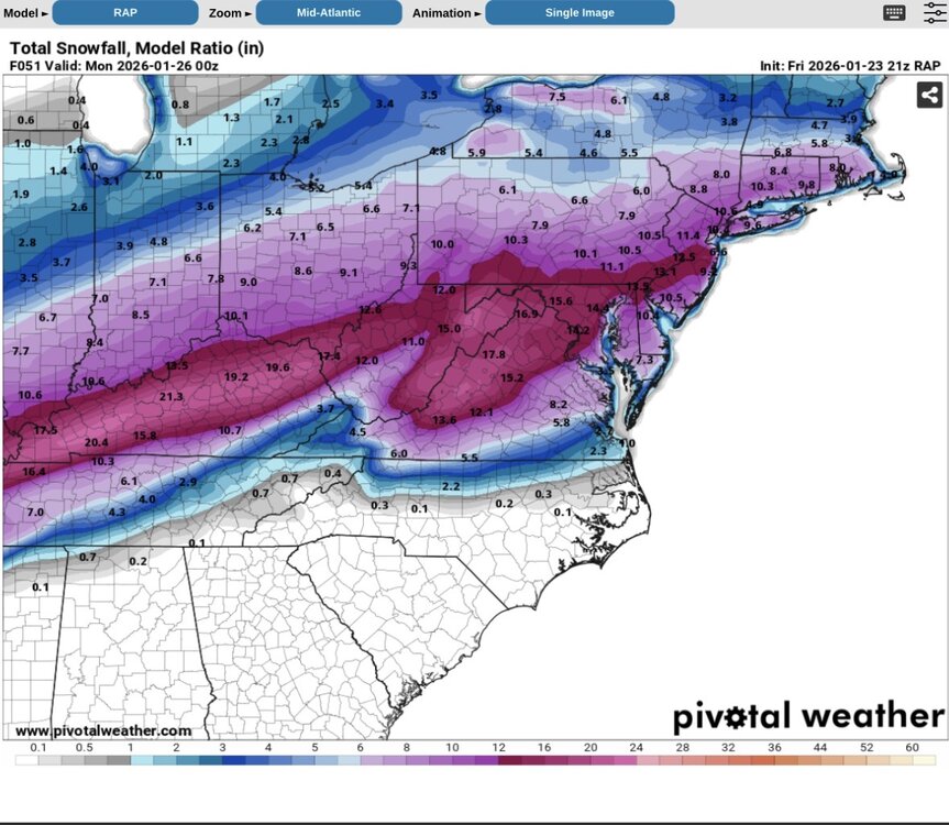
-
Im not sure i can do this again next week. Im too old for this shit
-
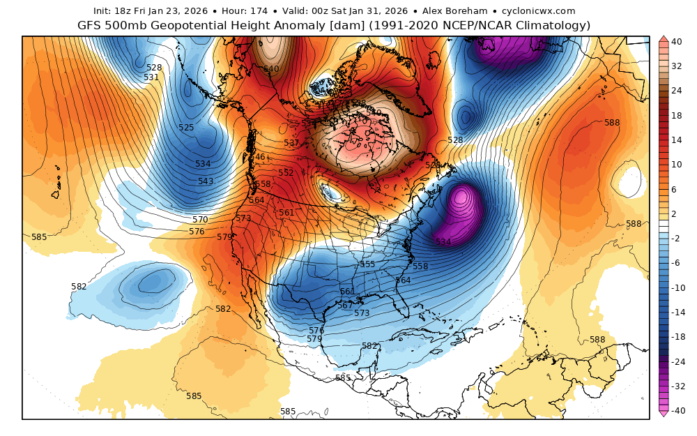
Wouldn't take much. Just as Randy said, the lobe pivoting around the PV under the nao needs to dive in and remain relevant.
-
That seems to lock in the cold behind it for the weekend system
-
@Scraff consuming this for HH

-
I originally like the nao and pv relax during the 27-29 thinking that would our window. Alas, thus period will likely be sandwiched by 2 windows that actually produce. Blew my load too soon gooning over it.
-
I have the 27-29th thing but that looks to fizzle out not surprisingly lol. Guess I gooned to soon.
-
January 25-26 Winter Storm Potential
Ralph Wiggum replied to Ralph Wiggum's topic in Philadelphia Region
At least Boston gets the golden shovel. They deserve it. -
January 25-26 Winter Storm Potential
Ralph Wiggum replied to Ralph Wiggum's topic in Philadelphia Region
I lost 8" snow on the nbm -
January 25-26 Winter Storm Potential
Ralph Wiggum replied to Ralph Wiggum's topic in Philadelphia Region
At this point im following the rule I posted above and expecting the 12k nam, or possibly even worse assuming it keeps trending. Anything better than that solution will leave me surprised and elated. -
January 25-26 Winter Storm Potential
Ralph Wiggum replied to Ralph Wiggum's topic in Philadelphia Region
.png.083879e3072130d3ec4c82c13738d5e7.png)
-
January 25-26 Winter Storm Potential
Ralph Wiggum replied to Ralph Wiggum's topic in Philadelphia Region
RGEM is colder than 12z fwiw. -
January 25-26 Winter Storm Potential
Ralph Wiggum replied to Ralph Wiggum's topic in Philadelphia Region
-
January 25-26 Winter Storm Potential
Ralph Wiggum replied to Ralph Wiggum's topic in Philadelphia Region
I am not discounting the NAM. It can be a frontrunner showing the thermal trends. I hope its wrong but there is a decent chance it is leading the way. Seen this before. Oh, and always go with the least snowy model. Weenie handbook first chapter, first sentence in the book! -
January 25-26 Winter Storm Potential
Ralph Wiggum replied to Ralph Wiggum's topic in Philadelphia Region
What was the story with this? I used to talk to the guy pretty regularly back in 1998-2002 then he just vanished. Hope it wasnt health related but I hear snippets of things that suggest otherwise. -
January 25-26 Winter Storm Potential
Ralph Wiggum replied to Ralph Wiggum's topic in Philadelphia Region
Some mixed signals across guidance that suggest maybe spots can hit that criteria with the Feb 1-3 storm threat. -
January 25-26 Winter Storm Potential
Ralph Wiggum replied to Ralph Wiggum's topic in Philadelphia Region
I think for you and I relatively speaking, 10" is our ceiling before mix. Hope we can hit the one foot mark tho, would love that! -
January 25-26 Winter Storm Potential
Ralph Wiggum replied to Ralph Wiggum's topic in Philadelphia Region
Oh brother, I poked the bear with a climo comment -
January 25-26 Winter Storm Potential
Ralph Wiggum replied to Ralph Wiggum's topic in Philadelphia Region
Agreed. When I think transfer i think upper level low transferring its energy. Redevelopment I picture a storm coming into the Tenn Valley and hitting a roadblock and being forced to redevelop farther downstream. I could be wrong tho. -
January 25-26 Winter Storm Potential
Ralph Wiggum replied to Ralph Wiggum's topic in Philadelphia Region
Absolutely. We were doing a comp.over in the mid atl sub the other day between the 2 storms. Very similar structurally. -
January 25-26 Winter Storm Potential
Ralph Wiggum replied to Ralph Wiggum's topic in Philadelphia Region
But 20 years ago this setup would never have pushed the mix line that far N and W as this one. And I understand this is more 700-800 mb layer stuff, but still. Yes, climo always N and W i agree. But when did i78 become the line? This is 4th or 5th time since 2018. -
January 25-26 Winter Storm Potential
Ralph Wiggum replied to Ralph Wiggum's topic in Philadelphia Region
The inevitable slow scale back has begun. -
January 25-26 Winter Storm Potential
Ralph Wiggum replied to Ralph Wiggum's topic in Philadelphia Region
Pretty incredible 10 years ago 202 would be 'the line' and even 15 years ago it would have been i95. Climo keeps pushing that line farther and farther n and w. -
January 25-26 Winter Storm Potential
Ralph Wiggum replied to Ralph Wiggum's topic in Philadelphia Region
That seems very reasonable for N of i78.


