CT Rain
-
Posts
26,253 -
Joined
-
Last visited
Content Type
Profiles
Blogs
Forums
American Weather
Media Demo
Store
Gallery
Everything posted by CT Rain
-

May obs/discussion thread - Welcome to Severe Season!!
CT Rain replied to weatherwiz's topic in New England
I agree. HREF is a soaker for WOR. -
May obs/discussion thread - Welcome to Severe Season!!
CT Rain replied to weatherwiz's topic in New England
Steined on the 12km NAM, soaked on the 3km NAM. -
lol
-
Booked a place in Whistler again for a week next January. Hope El Nino doesn't screw it up!
-
May obs/discussion thread - Welcome to Severe Season!!
CT Rain replied to weatherwiz's topic in New England
Better not look at the 18z. -
No kidding. It was awful the two times I had to do it.
-
Yeah Monday could be a bit torchy. Then the wheel of rhea settles back in. What a nasty pattern. It's a good thing Kevin installed a month ago.
-
Tough news for the install pre-April 15th crowd. Not a great look.
-
Yeah they're all over the place here. They always seem pretty spooked when they come across a human.
-
There are a lot here WOR. I see one every few months. Almost never bother people - just looking for food in trash cans.
-
You're a bizarre person.
-
93 BAF. The wind was pretty funky today. Hartford had a southerly wind this afternoon while BDL managed to switch to a SW or WSW breeze a few times when they spiked their temp. probably helped limit Sound influence and a bit of a downslope assist.
-
He keeps them in until Thanksgiving so why not?
-
No power for the UConn game?
-
Could be a severe threat Saturday WOR. The NAM and GFS have strong low level shear along with some modest surface based instability. The NAM in particular has 0-3km ~125j/kg in western Mass with quite a bit of 0-3km helicity. Worth watching along with a damaging gradient wind threat ahead of the fropa.
-
We went through an entire decade of incorrect 30 year normals for snowfall because they used 0s instead of Ms for the 3 years of missing BDL snowfall data.
-
The records are an absolute mess around here for snowfall. Not sure why the disconnect between the WFOs and NCEI over the last couple decades here.
-
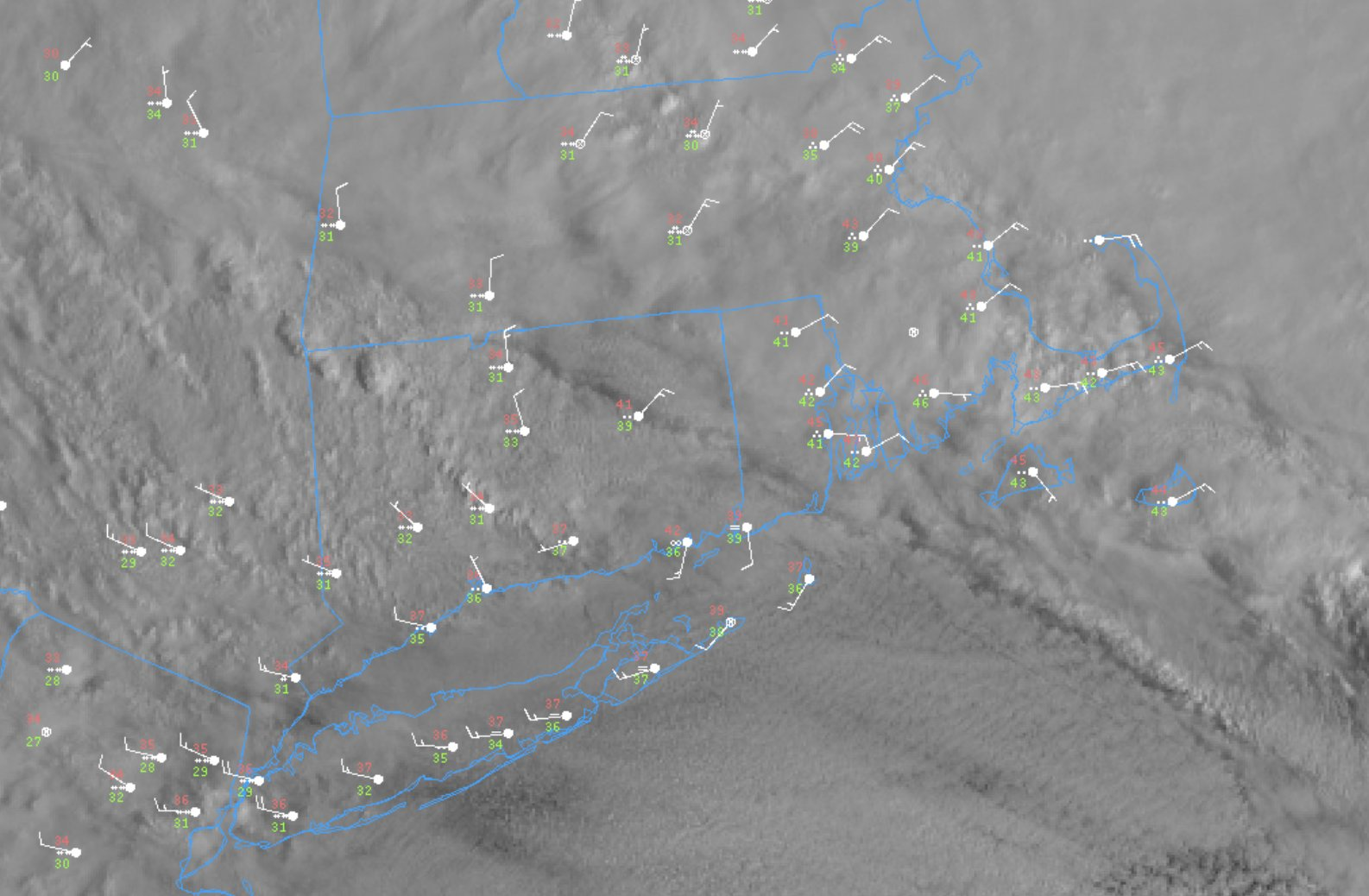
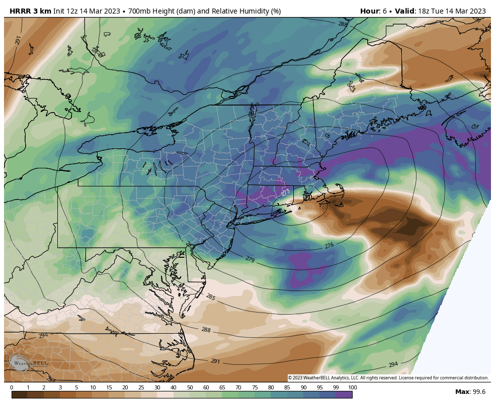
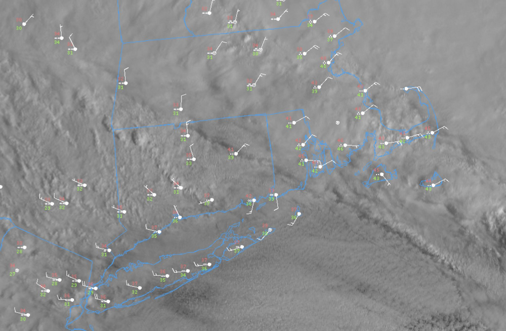
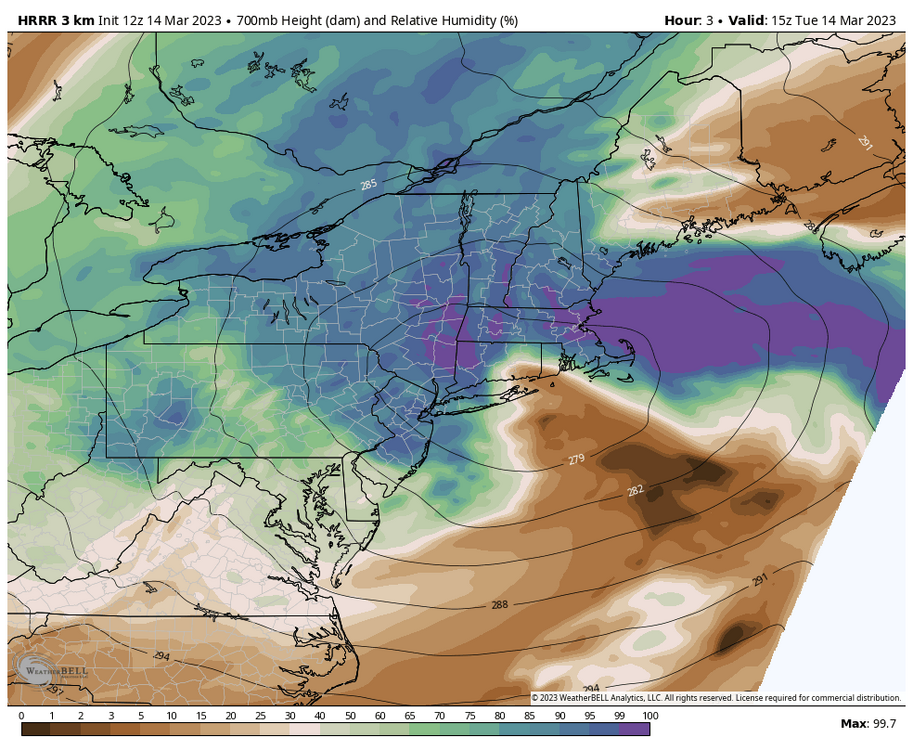
That nipple low is hanging out over E CT still. Should fill in shortly but that's what really screwed Kevin and NE CT overnight. A little tongue of warmth in the boundary layer - you could even see it between 9p and midnight when temperatures rose at IJD and the mesonet sites in E CT while they continued to fall HFD/BDL and points west. Now we wait for the 700mb low to consolidated and crash the comma head to the south and east. HRRR has ~0.5" liquid from 15z-21z for Hartford!

-
The last hurrah? Putting all the eggs in the Tuesday 3/14 basket
CT Rain replied to Ginx snewx's topic in New England
TBH most models are showing it. That sfc/925 low just sort of rot over C CT and torch just EOR. Ugly setup. -
The last hurrah? Putting all the eggs in the Tuesday 3/14 basket
CT Rain replied to Ginx snewx's topic in New England
ORH Hills are going to get destroyed. Looks like a pretty exceptional setup developing there. -
The last hurrah? Putting all the eggs in the Tuesday 3/14 basket
CT Rain replied to Ginx snewx's topic in New England
It's the remnant of the low level inverted trough. You can see it on a bunch of the models actually just around the 925mb low. I think this is going to be a large bust for most of CT outside of western areas which still looks quite good. -
The last hurrah? Putting all the eggs in the Tuesday 3/14 basket
CT Rain replied to Ginx snewx's topic in New England
That's a weird ass look. Most of the models have it too. -
The last hurrah? Putting all the eggs in the Tuesday 3/14 basket
CT Rain replied to Ginx snewx's topic in New England
I know. They're going to rip all night. What elevation are you at in Canton? Our weather watcher in Wolcott is flipping over now at 1kft. -
The last hurrah? Putting all the eggs in the Tuesday 3/14 basket
CT Rain replied to Ginx snewx's topic in New England
I doubt higher. Think 6ish is reasonable for you guys. The entire area from you down to Hartford on I-84 is probably my biggest uncertainty right now. I could see a bit of everything. Overperformer western areas and underperformer east.