

CT Rain
-
Posts
26,264 -
Joined
-
Last visited
Content Type
Profiles
Blogs
Forums
American Weather
Media Demo
Store
Gallery
Everything posted by CT Rain
-
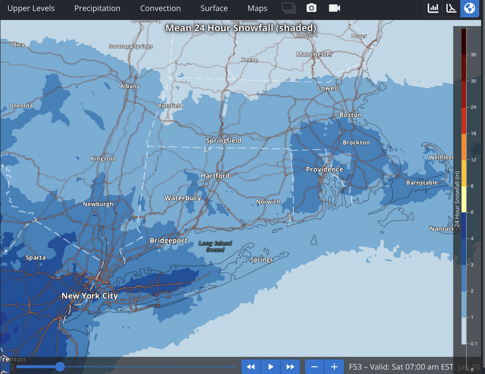
 Even looking at the 19z/20z HRRR there's a great banding/snow growth signal through most of CT up through boston.
 -
GFS isn't a total disaster
-
I think it still looks pretty good for you guys and most of S CT
-
Good lord. What a disaster.
-
Here's our first call. Only thing I don't like about the 18z GFS is that it brought the 700mb low a bit farther north. Have to watch that south of the Pike I think.
-
2m temps are a bit warm on the Euro for valley/shore at the onset. Kevin would be fine of course.
-
Yeah a partial phase would send this pretty far north. Definitely don't want any more of that south of the Pike.
-
What a strange way to live your life. Just posting on a weather board trying to troll people about snow. Imagine having the time to be so lame? Anyways the GFS looks great. That confluence to the north is going a long way here in making this event an actual event.
-
Did you even look at anything or are you just trolling?
-
I like how the h5 low closes off a bit as it moves offshore. A couple days ago it seemed like the thing was sort of shearing out and dampening some.
-
That improved confluence to the north increases the risk of suppression but it definitely helps with better cold air source and even better frontogenesis with a stronger baroclinic zone. Sort of playing with fire but I like the look now a lot better than 2 days ago.
-
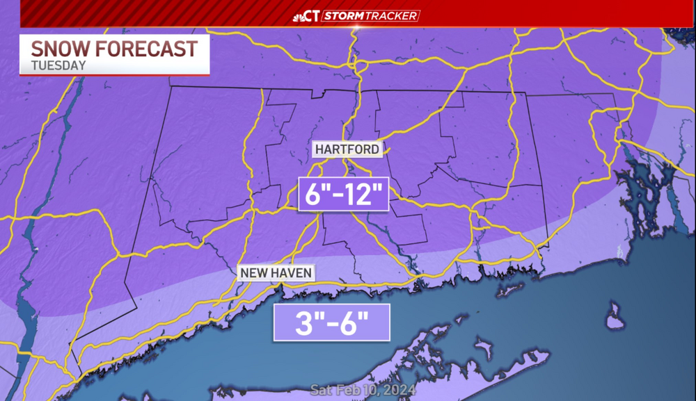
It was a Flop... February 2024 Disco. Thread
CT Rain replied to Prismshine Productions's topic in New England
No doubt overattribution along with some junk science (the stuff from Jennifer Francis has been pretty widely debunked, for example). But there's some stuff that seems pretty clear.... it's not much of a mystery as to what's happening. -
It was a Flop... February 2024 Disco. Thread
CT Rain replied to Prismshine Productions's topic in New England
And it's more than just that too... lower static stability over warm(er) waters, potential for stronger baroclinicity along the coast sometimes with a higher base state in water temps. Lots of second order effects here. I think there's a pretty strong case for an increase in the severity of some winter storms in the NE US/Atl Canada among other things (decrease in snow depth days, etc). -
That's awesome. Glad you had a good time and can't wait to see more!
-
I was there last year and it rained every day in the village and was sunny in the alpine. 0" base in the village and >100" in the alpine. It's the craziest weather variation I've ever seen day in and day out.
-
Incredible. They've had a pretty brutal season but we lucked out. Fresh powder most mornings and they had just enough snow the last couple weeks to open up the whole alpine. Looks like a disaster there now with heavy rain continuing.
-
It's pretty close to the 50th percentile NBM (which is also spitting out 16:1 or 17:1 ratios in RI and E Mass).
-
30 for you
-
Was thinking the same thing. There are a few Tippy stemwinders coming right up over SNE sub-970mb.
-
Where'd Kevin's ice storm go?
-
It's confusing following a million weenies on Twitter!
-
1/9-1/10 Now Morphing to Less-Than-Exciting Power Cutter
CT Rain replied to Torch Tiger's topic in New England
Downsloping off the Tug Hill?


