


yoda
-
Posts
63,813 -
Joined
Content Type
Profiles
Blogs
Forums
American Weather
Media Demo
Store
Gallery
Everything posted by yoda
-
Hail to 1 inch and isolated significant gusts to 75mph
-
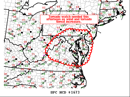
Mesoscale Discussion 1673 NWS Storm Prediction Center Norman OK 0206 PM CDT Thu Sep 03 2020 Areas affected...the Mid-Atlantic Concerning...Severe potential...Tornado Watch likely Valid 031906Z - 032100Z Probability of Watch Issuance...95 percent SUMMARY...A tornado watch will be needed this afternoon as a damaging wind and tornado threat increases. DISCUSSION...A broad area of shower activity extends from the Ohio Valley into Pennsylvania and New York amid a belt of strong mid-level flow. Areas south and east of this activity have slowly destabilized through the day with temperatures now in the upper 80s to low 90s in northern Virginia, eastern Maryland, and Delaware. In addition, the boundary layer is very moist with dewpoints in the mid to upper 70s. This has yielded moderate MLCAPE ranging from 1000 to 2000 J/kg across the region despite very weak mid-level lapse rates (5 C/km per 18Z IAD RAOB). Expect at least a few strong storms to develop in the eastern periphery of the cloud shield in the next 1-2 hours as destabilization continues and deep-layer ascent increases ahead of a shortwave moving out of West Virginia. Once storms develop, they will likely become supercellular, at least initially, given 40-45 kts of effective shear (per KLWX VWP and 18Z IAD RAOB). 18Z IAD RAOB showed relatively weak flow in the lowest 1.5 km, but upstream VWP from KRLX shows strong (40 kt) flow at 1km. Once this overspreads northern Virginia, Maryland, and Pennsylvania in a few hours, the damaging wind threat will increase and low-level shear will increase which should increase the tornado threat. The best tornado threat will likely be across northern Virginia, southern Maryland, and far southern Pennsylvania where there has been less mixing and surface winds remain southerly or south-southeasterly. A tornado watch will likely be needed in the next hour or two as storm coverage/intensity increases. ..Bentley/Grams.. 09/03/2020 ...Please see www.spc.noaa.gov for graphic product... ATTN...WFO...PHI...AKQ...CTP...LWX...RNK...PBZ...RLX...
-
MCD issued... tornado watch likely... 95 percent
-
Kind of surprised no MCD yet from SPC
-
Ugh it's hot and humid out... we better get some storms this afternoon
-
On your marks... Tropical Weather Outlook NWS National Hurricane Center Miami FL 200 AM EDT Thu Sep 3 2020 For the North Atlantic...Caribbean Sea and the Gulf of Mexico: The National Hurricane Center is issuing advisories on recently upgraded Hurricane Nana, approaching the coast of Belize, and on Tropical Depression Omar, located a few hundred miles north of Bermuda. 1. A broad area of low pressure located over the eastern tropical Atlantic several hundred miles west-southwest of the Cabo Verde Islands continues to produce a small area of showers and thunderstorms. This system is expected to interact with a tropical wave approaching from the east over the weekend, and it is unclear if the interaction will enhance or inhibit development of this system while it meanders over the eastern and central tropical Atlantic through early next week. * Formation chance through 48 hours...low...20 percent. * Formation chance through 5 days...low...30 percent. 2. A tropical wave located off the coast of west Africa is merging with another disturbance located a couple of hundred miles south of the Cabo Verde Islands, resulting in an extensive area of disorganized showers and thunderstorms. Development of this system is likely to be slow during the next couple of days while it moves west- northwestward at about 15 mph, and a tropical depression is more likely to form early next week over the central tropical Atlantic where environmental conditions are forecast to be more favorable for development. * Formation chance through 48 hours...low...20 percent. * Formation chance through 5 days...high...70 percent. 3. Another tropical wave is forecast to move off the west coast of Africa over the weekend. An area of low pressure is expected to form from the wave, and some development of this low will be possible early next week while it moves generally westward over the far eastern tropical Atlantic. * Formation chance through 48 hours...low...near 0 percent. * Formation chance through 5 days...low...20 percent. Forecaster Berg
-
I wouldn't say busted looking at the reports https://www.spc.noaa.gov/exper/archive/event.php?date=20120601
-
New day 1 is out.... 0600 OTLK is ENH risk with 10 TOR/5 HAIL/30 WIND
-
June 4th and June 10th and June 16th 2008 were MOD risks... but for wind down here
-
I believe this is the last event that had hatched tor probs in the LWX CWA https://www.spc.noaa.gov/exper/archive/event.php?date=20160224
-
Evening AFD LWX disco update for tomorrow
-
Those were at KIAD... KDCA and KEZF look a bit more nasty... along with KBWI too ETA: especially that sounding at KBWI at 00z Friday
-
Again with the no sprinkler
-
Those are some nasty soundings on the 00z NAM from 18z THURS to 03z FRI
-
Are we going to use this thread for both days? Or should we risk getting denied by posting a separate thread lol
-
Tornado watch coming shortly
-
LWX goes big for today and tomorrow in their morning AFD
-
SPC doesn't like today for us... but tomorrow... woah at the disco... here is the morning Day 2
-
00z NAM soundings for both tomorrow and Thursday look pretty nice... Thursday looks a lil better IMO due to a bit stronger deep layer shear
-
8pm TWO mentions 30 percent chance for that to develop 1. Showers and thunderstorms associated with a small area of low pressure about midway between the Windward Islands and west Africa appear to be slowly becoming better organized. Some additional development of this system is possible this week as the system meanders in the central tropical Atlantic Ocean. * Formation chance through 48 hours...low...20 percent. * Formation chance through 5 days...low...30 percent.
-
MRGL remains for Day 2 on 1730 SPC OTLK... but talks of an upgrade
-
Now let's see if this system sneaks in a quick name change from TD 15 to Omar before its gone
-
True. You could only go high risk here if the event was unfolding with as you say numerous tornadoes (EF2 or something) or a derecho coming in from the west. The derecho in 2012 however, caught the region, including local TV mets off-guard per the NWS report though.
-
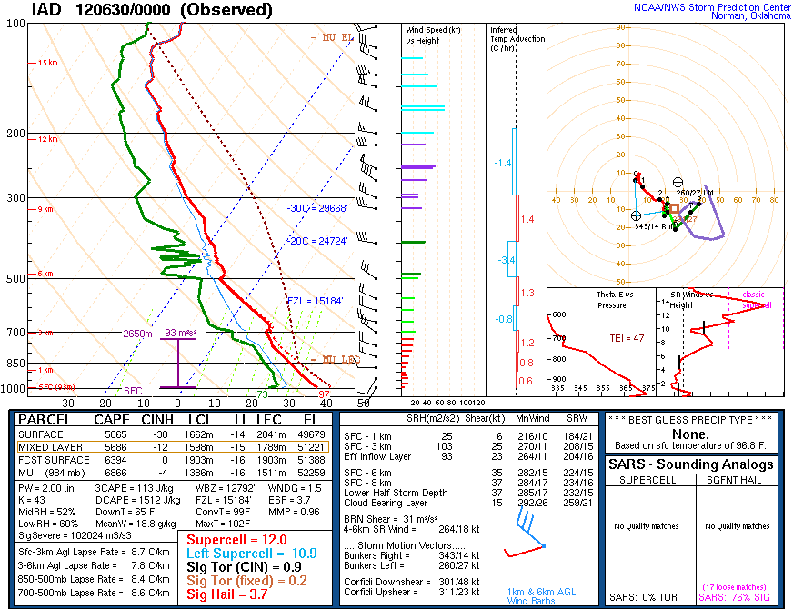
Here's the sounding
-
I don't think we will ever see a high risk here -- even the derecho in late June that was rampaging through the Ohio Valley the night of the infamous 00z LWX sounding (102/70 I think it was with nearly 6000 SBCAPE) only garnered a moderate risk on the 2000 SPC OTLK and the 0100 OTLK


