yoda
-
Posts
62,582 -
Joined
Content Type
Profiles
Blogs
Forums
American Weather
Media Demo
Store
Gallery
Everything posted by yoda
-
00z NAM still has some decent looking soundings at 21z tomorrow around the region
-
DCA sounding at 21z tomorrow per 18z NAM

-
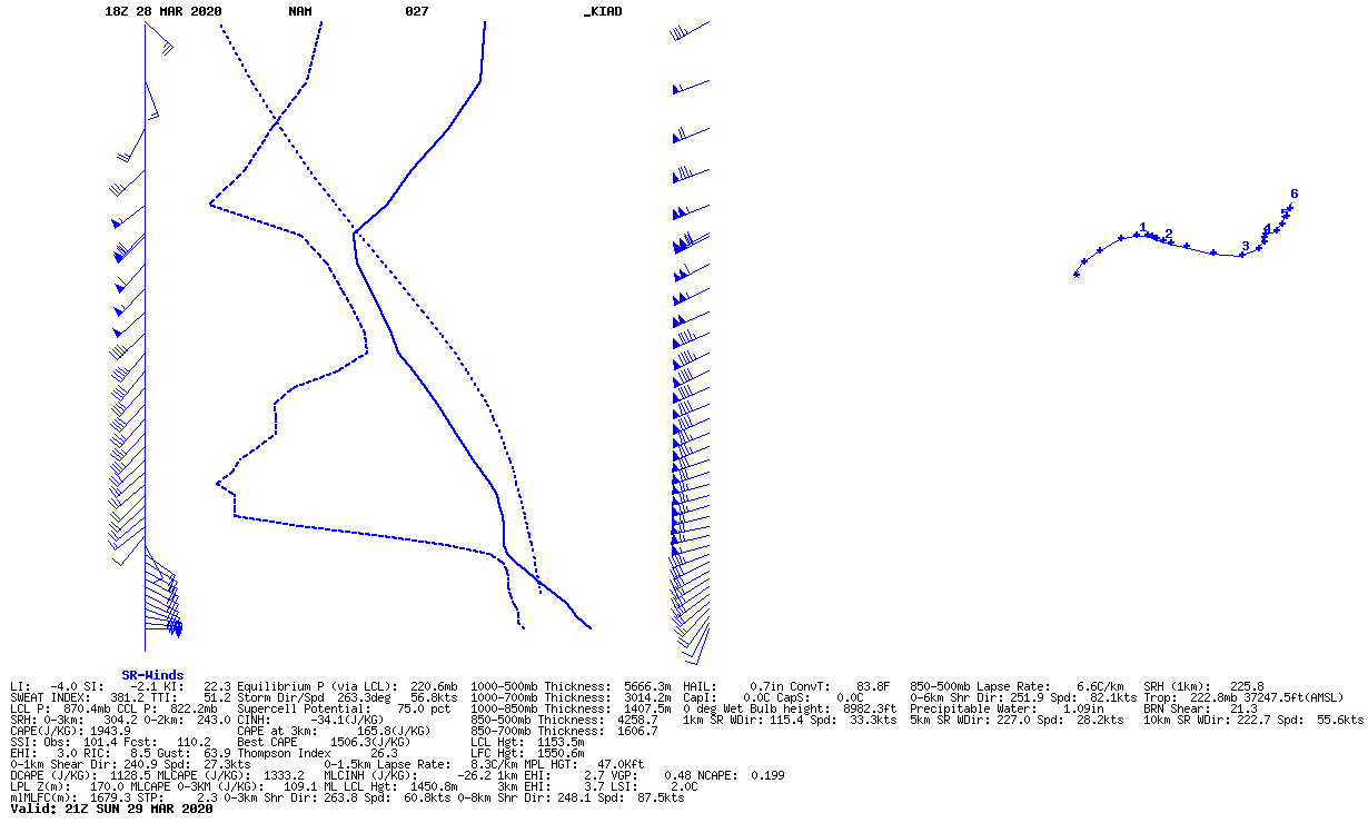
@high risk Pretty decent sounding from the 18z NAM for 21z tomorrow at KIAD, no?

-
Afternoon AFD from LWX:
-
1730 SPC OTLK from day 2 has all of us in 2/5/5... mentions supercells with all hazards possible but conditional threat... here is the disco for our region:
-
Looks like our first chance in a while of some thunderstorms, maybe even an isolated severe threat is on Sunday afternoon
-
Tornado Watch coming shortly - https://www.spc.noaa.gov/products/md/md0169.html Mesoscale Discussion 0169 NWS Storm Prediction Center Norman OK 1113 AM CDT Thu Mar 12 2020 Areas affected...Southwest MO/MO Bootheel...Southern IL...Western KY...Northwest/Middle TN Concerning...Severe potential...Tornado Watch likely Valid 121613Z - 121815Z Probability of Watch Issuance...80 percent SUMMARY...Ongoing thunderstorms as well as the potential for more storms this afternoon and evening will likely necessitate Tornado Watch issuance within the next hour. DISCUSSION...Cluster of thunderstorm currently ongoing across the MO Bootheel eastward into far northwest TN/far western KY has shown a general strengthening trend over the past hour or so. This cluster appears to have been initiated by the low/mid jet streak extending from eastern OK into northern AR/southern MO. This jet streak is expected to continue eastward throughout the day, providing both mesoscale forcing for ascent as well as enhanced low-level vertical shear. The ongoing cluster is evidence that the ascent is enough to lift parcels to their LFCs and the rotation noted in these cells, particularly those over the MO Bootheel and far northwest TN, is evidence of the enhanced vertical shear. Expectation is for this cluster to continue northeastward/eastward. More eastward moving storms will maintain a closer proximity to the warm front extending across the region, resulting in access to greater low-level moisture and higher surface-based potential. Current surface analysis places the warm front from just south of the MO Bootheel east-northeastward to BNA. Primary threat with the elevated/more northeastward-progressing storms will be hail, but the more surface-based/eastward-progressing storms will also have the potential to produce damaging wind gusts and tornadoes. These threats will likely prompt watch issuance within the next hour. ..Mosier/Hart.. 03/12/2020 ...Please see www.spc.noaa.gov for graphic product... ATTN...WFO...LMK...OHX...PAH...MEG...
-
SPC has us mentioned in the 1730 DAY 2 OTLK for maybe some gusty winds tomorrow afternoon... no MRGL, just general FWIW
-
I like Bob's WDI better lol
-
Maybe something to look forward to next week? From the Day 4-8 SPC OTLK:
-
PRELIMINARY LOCAL STORM REPORT NATIONAL WEATHER SERVICE BALTIMORE MD/WASHINGTON DC 1054 PM EST TUE MAR 03 2020 ..TIME... ...EVENT... ...CITY LOCATION... ...LAT.LON... ..DATE... ....MAG.... ..COUNTY LOCATION..ST.. ...SOURCE.... ..REMARKS.. 1048 PM TSTM WND GST HAGERSTOWN RGNL ARPT 39.71N 77.73W 03/03/2020 M68 MPH WASHINGTON MD ASOS && EVENT NUMBER LWX2000782
-
BULLETIN - IMMEDIATE BROADCAST REQUESTED Severe Thunderstorm Warning National Weather Service Baltimore MD/Washington DC 1054 PM EST Tue Mar 3 2020 The National Weather Service in Sterling Virginia has issued a * Severe Thunderstorm Warning for... Eastern Washington County in north central Maryland... Carroll County in north central Maryland... Northwestern Montgomery County in central Maryland... Frederick County in north central Maryland... Northeastern Loudoun County in northern Virginia... East central Frederick County in northwestern Virginia... Northeastern Clarke County in northwestern Virginia... Jefferson County in the Panhandle of West Virginia... * Until 1130 PM EST. * At 1054 PM EST, severe thunderstorms were located along a line extending from near Carroll Valley to 6 miles west of Charles Town, moving east at 70 mph. HAZARD...70 mph wind gusts. SOURCE...Trained weather spotters. IMPACT...Damaging winds will cause some trees and large branches to fall. This could injure those outdoors, as well as damage homes and vehicles. Roadways may become blocked by downed trees. Localized power outages are possible. Unsecured light objects may become projectiles. * Locations impacted include... Frederick, Westminster, Damascus, Thurmont, Charles Town, Poolesville, Emmitsburg, Shepherdstown, Harry Grove Stadium, Ballenger Creek, Mount Airy, Robinwood, Taneytown, Brunswick, Walkersville, Manchester, Ranson, Boonsboro, Smithsburg and Braddock Heights.
-
Southern part of the line just had the warning cancelled by LWX
-
Doesn't look like HRRR really had this "line" looking back at the 01z/02z run... kinda intriguing though
-
BULLETIN - IMMEDIATE BROADCAST REQUESTED Severe Thunderstorm Warning National Weather Service Baltimore MD/Washington DC 1028 PM EST Tue Mar 3 2020 The National Weather Service in Sterling Virginia has issued a * Severe Thunderstorm Warning for... Shenandoah County in northwestern Virginia... Southern Frederick County in northwestern Virginia... Northwestern Rockingham County in western Virginia... Southern Clarke County in northwestern Virginia... Northwestern Warren County in northwestern Virginia... North central Page County in northwestern Virginia... The southwestern City of Winchester in northwestern Virginia... Northeastern Pendleton County in eastern West Virginia... Southeastern Grant County in eastern West Virginia... Hardy County in eastern West Virginia... Southern Hampshire County in eastern West Virginia... * Until 1115 PM EST. * At 1028 PM EST, severe thunderstorms were located along a line extending from 11 miles southwest of Romney to 6 miles north of Upper Tract, moving southeast at 45 mph. HAZARD...60 mph wind gusts. SOURCE...Trained weather spotters. IMPACT...Damaging winds will cause some trees and large branches to fall. This could injure those outdoors, as well as damage homes and vehicles. Roadways may become blocked by downed trees. Localized power outages are possible. Unsecured light objects may become projectiles. * Locations impacted include... Winchester, Front Royal, Strasburg, Woodstock, Moorefield, Petersburg, Millwood Pike, Rough Run, Berryville, Broadway, Timberville, Mount Jackson, Stephens City, Wardensville, Basye-Bryce Mountain, Upper Tract, Mathias, Star Tannery, New Market and Middletown. PRECAUTIONARY/PREPAREDNESS ACTIONS... For your protection move to an interior room on the lowest floor of a building.
-
Well.. they are being issued per spotters... but interesting warnings... @high risk BULLETIN - IMMEDIATE BROADCAST REQUESTED Severe Thunderstorm Warning National Weather Service Baltimore MD/Washington DC 1026 PM EST Tue Mar 3 2020 The National Weather Service in Sterling Virginia has issued a * Severe Thunderstorm Warning for... Washington County in north central Maryland... East central Allegany County in western Maryland... Northwestern Frederick County in north central Maryland... North central Loudoun County in northern Virginia... Central Frederick County in northwestern Virginia... Northern Clarke County in northwestern Virginia... The City of Winchester in northwestern Virginia... Jefferson County in the Panhandle of West Virginia... Morgan County in the Panhandle of West Virginia... Berkeley County in the Panhandle of West Virginia... Northern Hampshire County in eastern West Virginia... * Until 1100 PM EST. * At 1026 PM EST, severe thunderstorms were located along a line extending from 6 miles southwest of Claylick to 11 miles southeast of Romney, moving east at 75 mph. HAZARD...60 mph wind gusts. SOURCE...Emergency management. IMPACT...Damaging winds will cause some trees and large branches to fall. This could injure those outdoors, as well as damage homes and vehicles. Roadways may become blocked by downed trees. Localized power outages are possible. Unsecured light objects may become projectiles. * Locations impacted include... Hagerstown, Winchester, Martinsburg, Thurmont, Charles Town, Emmitsburg, Romney, Shepherdstown, Hancock, Paw Paw, Municipal Stadium, Robinwood, Brunswick, Fountainhead-Orchard Hills, Ranson, Berryville, Boonsboro, Smithsburg, Inwood and Paramount-Long Meadow. PRECAUTIONARY/PREPAREDNESS ACTIONS... For your protection move to an interior room on the lowest floor of a building.
-
yay -- https://www.spc.noaa.gov/products/md/md0146.html Mesoscale Discussion 0146 NWS Storm Prediction Center Norman OK 0327 PM CST Tue Mar 03 2020 Areas affected...much of Pennsylvania...Maryland...West Virginia...and western through northern Virginia Concerning...Severe potential...Watch unlikely Valid 032127Z - 032330Z Probability of Watch Issuance...20 percent SUMMARY...Relatively shallow convection continues to migrate eastward into the discussion area and will continue to pose a threat of isolated damaging wind gusts and small hail. A WW issuance is not anticipated for this activity. DISCUSSION...Relatively shallow convection continues within an axis of weak instability extending from near FKL to EKN to BKW. Ahead of this axis, insolation has allowed for temperatures to rise into the low 60s amidst mid/upper 40s F dewpoints. Cooling associated with advancement of a mid-level wave across the region has contributed to the destabilization and will likely allow for this axis of instability to spread eastward in tandem with convection across the discussion area over the next couple hours or so. A mix of cellular and linear convection should continue, which will allow for occasional updraft rotation given strong shear and fast flow aloft. Any wind/hail threat should be mostly diurnally driven and wane after dark with the onset of nocturnal boundary layer cooling. Furthermore, the weak instability is limiting the overall magnitude of the severe threat, precluding a WW issuance. ..Cook/Hart.. 03/03/2020 ...Please see www.spc.noaa.gov for graphic product... ATTN...WFO...CTP...LWX...RNK...PBZ...RLX...
-
Decent storms in C WV.... guess we shall see what makes it into W VA in the next few hours
-
Really clearing out here now... I can see a lot of blue sky ETA: @George BM beat me to the punch with the sat pic
-
Well he's following the Eskimo Joe school... so you can see where he gets it from
-
No... 5% TOR
-
Sun coming out here
-
19 confirmed dead now -- https://www.yahoo.com/gma/tornado-directly-hits-nashville-extensive-damage-reported-082805483--abc-news-topstories.html
-
1300 SPC OTLK still 2% TOR/5% WIND... but disco has picked up a bit compared to the 0600 one
-
8 confirmed deaths https://news.yahoo.com/national-weather-confirms-tornado-near-074153755.html?.tsrc=bell-brknews