yoda
-
Posts
62,930 -
Joined
Content Type
Profiles
Blogs
Forums
American Weather
Media Demo
Store
Gallery
Everything posted by yoda
-
@high risk is correct... new morning Day 1 OTLK has SLGT for most of LWX CWA... 5% hail and 15% wind 0600z OTLK disco:
-
Maybe some get the storms warned in N WV that are moving SE later?
-
or this Severe Weather Statement National Weather Service Buffalo NY 1244 AM EDT Wed Jun 3 2020 NYC003-009-030530- /O.CON.KBUF.SV.W.0024.000000T0000Z-200603T0530Z/ Cattaraugus NY-Allegany NY- 1244 AM EDT Wed Jun 3 2020 ...A SEVERE THUNDERSTORM WARNING REMAINS IN EFFECT UNTIL 130 AM EDT FOR SOUTHEASTERN CATTARAUGUS AND SOUTHERN ALLEGANY COUNTIES... At 1243 AM EDT, a severe thunderstorm was located near Cuba, or 7 miles north of Olean, moving southeast at 45 mph. HAZARD...70 mph wind gusts and quarter size hail. SOURCE...Radar indicated. IMPACT...Minor damage to vehicles is possible. Expect considerable tree damage. Wind damage is also likely to mobile homes, roofs, and outbuildings. Locations impacted include... Olean, Salamanca, Wellsville, Allegany State Park, Ashford, Allegany, Franklinville, Belfast, Cuba and St. Bonaventure. This includes Interstate 86 between exits 21 and 31. PRECAUTIONARY/PREPAREDNESS ACTIONS... This is a DANGEROUS SITUATION. This storm has the potential to produce widespread wind damage across eastern Cattaraugus and western Allegany counties. SEEK SHELTER NOW inside a sturdy structure and stay away from windows! Continuous cloud to ground lightning is occurring with this storm. Move indoors immediately. Lightning is one of nature`s leading killers. Remember, if you can hear thunder, you are close enough to be struck by lightning.
-
Don't see this often at 1 am in NY Severe Weather Statement National Weather Service Binghamton NY 1250 AM EDT Wed Jun 3 2020 NYC109-030515- /O.CON.KBGM.SV.W.0026.000000T0000Z-200603T0515Z/ Tompkins NY- 1250 AM EDT Wed Jun 3 2020 ...A SEVERE THUNDERSTORM WARNING REMAINS IN EFFECT UNTIL 115 AM EDT FOR TOMPKINS COUNTY... At 1249 AM EDT, a severe thunderstorm was located over Ithaca, moving southeast at 55 mph. HAZARD...Ping pong ball size hail and 60 mph wind gusts. SOURCE...Radar indicated. IMPACT...People and animals outdoors will be injured. Expect hail damage to roofs, siding, windows, and vehicles. Expect wind damage to roofs, siding, and trees. Locations impacted include... Ithaca, Newfield, Cayuga Heights, Lansing, Enfield, Danby, Caroline, Dryden, Trumansburg and South Danby. PRECAUTIONARY/PREPAREDNESS ACTIONS... For your protection move to an interior room on the lowest floor of a building. This storm is producing large hail. SEEK SHELTER NOW inside a sturdy structure and stay away from windows. Heavy rainfall is occurring with this storm, and may lead to flash flooding. Do not drive your vehicle through flooded roadways.
-
STW up for ping pong ball sized hail till 1245 am... impressive... for parts of Wyoming/Erie/Allegany counties
-
Very interesting notes from SPC today about May 2020 severe weather wise
-
I've been watching some of what has been going on in MN/WI... and seems like HRRR was a big whiff
-
SPC morning Day 2 disco
-
-
SPC morning Day 2 has moved SLGT risk south some... it is now just north of a Harrisonburg, VA to EZF line.... 2/15/15
-
An excellent choice
-
Is it bad that I immediately thought of the scene between Darth Vader and Lando on Bespin in The Empire Strikes Back?
-
So looks like we probably have 2 chances then... Wednesday afternoon into night and then again Friday afternoon
-
Afternoon AFD from LWX discussing severe for Wed to Fri time period:
-
FYI in case this wasn't posted earlier: PUBLIC INFORMATION STATEMENT NATIONAL WEATHER SERVICE BALTIMORE MD/WASHINGTON DC 1053 AM EDT FRI MAY 29 2020 ...PUBLIC INFORMATION STATEMENT... ...SUSPENSION OF OBSERVATIONS AT NWS AUTOMATED SURFACE OBSERVATION SYSTEM AT BALTIMORE MD INNER HARBOR... THE NWS HAS BEEN NOTIFIED THAT CONSTRUCTION AFFECTING THE GROUNDS AROUND THE NWS AUTOMATED SURFACE OBSERVATION SYSTEM (ASOS) BALTIMORE INNER HARBOR (KDMH) IS PROGRESSING, AND OUR EQUIPMENT NEEDS TO BE REMOVED FOR A TIME. THE SUSPENSION OF KDMH OBSERVATIONS IS SCHEDULED TO BEGIN ON TUESDAY JUNE 2, 2020. DATA WILL BE LISTED AS MISSING IN THE DAILY CLIMATE REPORT (CLIDMH) AND PRELIMINARY MONTHLY CLIMATE DATA (CF6DMH). WE WILL PROVIDE MORE INFORMATION ABOUT RESTORATION OF THE EQUIPMENT AND OBSERVATION WHEN WE RECEIVE IT FROM THE CONSTRUCTION COMPANY. CONSTRUCTION AT JOSEPH H. RASH MEMORIAL PARK ON BALTIMORE'S INNER HARBOR WILL IMPACT THE NWS AUTOMATED SURFACE OBSERVATION SYSTEM (ASOS) BALTIMORE INNER HARBOR MARYLAND (KDMH) STATION LOCATED THERE. TO ALLOW FOR SITE WORK, THE KDMH ASOS SENSORS NEED TO BE REMOVED AND STORED UNTIL CONSTRUCTION IS COMPLETED. AFTER THE CONSTRUCTION IS COMPLETED, KDMH WILL BE RE-ESTABLISHED WITHIN RASH MEMORIAL PARK.
-
Has this mainly been on the NAM? Or has the GFS and EURO been having the same? And those are some large matches by hail size... probably helped by the eastward moving EML with between 7.5 and 8.0 C/KM mid level Lapse rates
-
Well I hope people aren't expecting 2012 to be walking through the door... cause that's just silly
-
I consider low to mid 90s a hot air mass with DPs near 70
-
Will be interesting to see what the Day 3 SPC OTLK looks like
-
00z NAM showing ML Lapse Rates around 7.0 C/KM for Wednesday afternoon into the evening
-
https://www.spc.noaa.gov/exper/archive/event.php?date=20000809 All the watches, MCDs, and text products issued during the day... plus storm reports as well
-
Should be in the SPC archives ETA: @George BM beat me to it
-
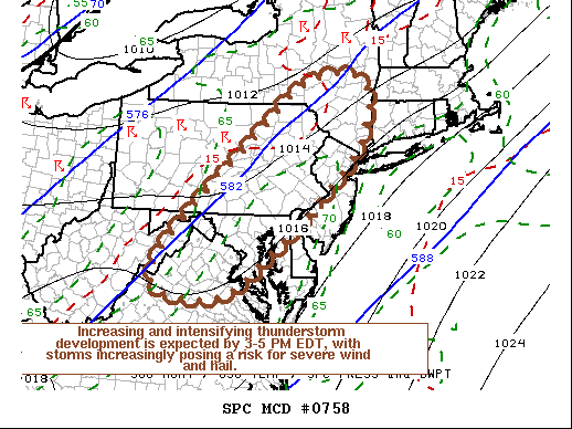
https://www.spc.noaa.gov/products/md/md0758.html Mesoscale Discussion 0758 NWS Storm Prediction Center Norman OK 1127 AM CDT Fri May 29 2020 Areas affected...Northern Mid Atlantic Coast region Concerning...Severe potential...Severe Thunderstorm Watch likely Valid 291627Z - 291730Z Probability of Watch Issuance...80 percent SUMMARY...Thunderstorms may develop across the Poconos and Catskills vicinity as early as the next hour or or so, with a more general increase and intensification of thunderstorm during the 3-5 PM EDT time frame. With strongest storms expected to pose at least a risk for severe wind and hail, one or more severe weather watches seems probable. DISCUSSION...Insolation within a seasonably moist boundary layer (surface dew points around/above 70F) is contributing to moderately large CAPE on the order of 1000-2000+ J/kg, within deepening surface troughing to the lee of the Appalachians. Mid-level flow remains broadly anticyclonic, however deepening convective development is underway aided by orography, particularly across the Poconos into Catskills vicinity. As a short wave trough accelerates northeast of the middle Ohio Valley/central Appalachians region, mid-level flow appears likely to trend increasingly cyclonic across northern Virginia through eastern New York state. This should contribute to an environment increasingly conducive to thunderstorm initiation and intensification. A coinciding strengthening of southwesterly mid-level flow (30-50 kt around 500 mb), will provide sufficient shear for organizing lines and clusters of storms, with isolated discrete supercells also possible. At least some of this activity will pose a risk for large hail, potentially damaging wind gusts, and perhaps a tornado or two. ..Kerr/Grams.. 05/29/2020 ...Please see www.spc.noaa.gov for graphic product... ATTN...WFO...OKX...ALY...PHI...BGM...AKQ...CTP...LWX..