

yoda
-
Posts
63,572 -
Joined
Content Type
Profiles
Blogs
Forums
American Weather
Media Demo
Store
Gallery
Everything posted by yoda
-
I'll take the 00z GFS
-
FYI from the evening LWX AFD update:
-
I'll be back in a bit after seeing this
-
30 to 33 looks like
-
And @MillvilleWx just called for a snow nuke
-
Getting smoked on the 00z 3km NAM at 36... r/s line barely in S MD
-
Hopefully its real and not banter lol
-
18z ICON pretty much crushes the region nicely
-
Nah Ji's posts would get so many dislikes it would break the board
-
You just have to complain about something
-
That should make @WinterWxLuvr happy
-
998mb just SE of Ocean City at 45... almos looks like a deform band lol
-
r/s approaches SE St. Mary's
-
Pouring snow at 39... r/s line not even close
-
18z NAM has a 1007mb SLP in S AR at 27
-
ooooh I have lots of DOGE
-
RNK has WSW for all of its zones for 4-8 if hasn't been posted already... was issued at noon
-

Feb Long Range Discussion (Day 3 and beyond) - MERGED
yoda replied to WinterWxLuvr's topic in Mid Atlantic
lulz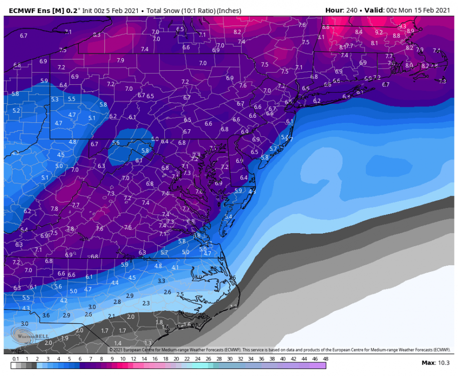
-
That's quite a big yes on the 06z run
-
1" QPF at DCA on 06z 3km NAM
-
I'll hug the 06z 3k NAM run
-
0.5 to 1.0 inches of ice
-
Feb Long Range Discussion (Day 3 and beyond) - MERGED
yoda replied to WinterWxLuvr's topic in Mid Atlantic
1008mb SLP near CHS at 240 with 1039mb HP in E Quebec Light snow in DC -
I'd rather have the NAM twins lol... but 2-4 would be great as we go into the week ahead
-
@psuhoffman your last 2 posts are in the wrong thread


