yoda
-
Posts
63,691 -
Joined
Content Type
Profiles
Blogs
Forums
American Weather
Media Demo
Store
Gallery
Everything posted by yoda
-

Feb Long Range Discussion (Day 3 and beyond) - MERGED
yoda replied to WinterWxLuvr's topic in Mid Atlantic
There goes the HP out to sea on the GFS at 153... cant wait for my rain -
Feb Long Range Discussion (Day 3 and beyond) - MERGED
yoda replied to WinterWxLuvr's topic in Mid Atlantic
Para GFS laughs in our faces for Saturday -
Feb Long Range Discussion (Day 3 and beyond) - MERGED
yoda replied to WinterWxLuvr's topic in Mid Atlantic
Just about time to turn out the lights on this supposedly great two weeks that was predicted on the models of snow and ice -
Feb Long Range Discussion (Day 3 and beyond) - MERGED
yoda replied to WinterWxLuvr's topic in Mid Atlantic
Lol 1030mb HP on GFS -
Happen to have total QPF?
-
Feb Long Range Discussion (Day 3 and beyond) - MERGED
yoda replied to WinterWxLuvr's topic in Mid Atlantic
Yes... but what happened to Saturday ice storm? -
-
Huh? NAMs were wetter than 12z
-
https://mobile.twitter.com/NWS_BaltWash/status/1360006014494408704
-
Feb Long Range Discussion (Day 3 and beyond) - MERGED
yoda replied to WinterWxLuvr's topic in Mid Atlantic
That's asking for too much IMO -
Wouldnt mind seeing a little bit of snow... like half inch would be a miracle though
-
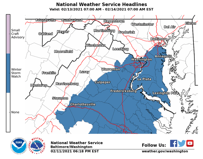
Good luck guys down in C VA/S MD/EZF... from afternoon AFD from LWX
-
LWX AFD afternoon update
-
If snow is included. If its just ice, ice storm warning is issued
-
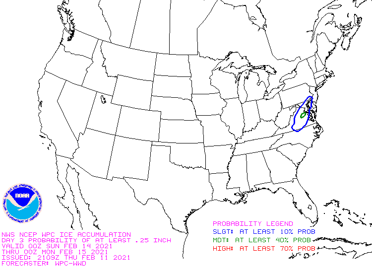
AKQ just went WSWatch for their zones for around a quarter inch of ice... watch is from late Friday night into Saturday evening
-
Would be kind of funny if we get a WSWatch for ice and this time it verifies
-
Feb Long Range Discussion (Day 3 and beyond) - MERGED
yoda replied to WinterWxLuvr's topic in Mid Atlantic
True... but it's better then this snow pattern we were supposedly going into that has turned into a big lie... don't worry though... large cutter brings 50s to near 60 Day 9 -
Feb Long Range Discussion (Day 3 and beyond) - MERGED
yoda replied to WinterWxLuvr's topic in Mid Atlantic
Woof for ice and rain sure -
Feb Long Range Discussion (Day 3 and beyond) - MERGED
yoda replied to WinterWxLuvr's topic in Mid Atlantic
Hmmm... ISW for the weekend coming? -
No lol... total snow accums is what it reads... not additional
-
Feb Long Range Discussion (Day 3 and beyond) - MERGED
yoda replied to WinterWxLuvr's topic in Mid Atlantic
3" of ice in Harrisonburg through 204... closing in on 2 inches in DC -
I'm enjoying my 33 and rain
-
Feb Long Range Discussion (Day 3 and beyond) - MERGED
yoda replied to WinterWxLuvr's topic in Mid Atlantic
At 150 its tight... but its 23 and RIPPING snow at DCA