yoda
-
Posts
63,575 -
Joined
Content Type
Profiles
Blogs
Forums
American Weather
Media Demo
Store
Gallery
Everything posted by yoda
-

Feb Long Range Discussion (Day 3 and beyond) - MERGED
yoda replied to WinterWxLuvr's topic in Mid Atlantic
The 06z GEFS ensemble mean for snow went up 2-3" compared to 00z for just about everyone... wow -
Feb Long Range Discussion (Day 3 and beyond) - MERGED
yoda replied to WinterWxLuvr's topic in Mid Atlantic
Woah... para 06z GFS was a nice hit ETA: Especially those S and E of i95 corridor -
Feb Long Range Discussion (Day 3 and beyond) - MERGED
yoda replied to WinterWxLuvr's topic in Mid Atlantic
Wonder if 06z GEFS will up the ante a bit from its 00z run -
Feb Long Range Discussion (Day 3 and beyond) - MERGED
yoda replied to WinterWxLuvr's topic in Mid Atlantic
I'm not even sure where the run was going after... there is h5 energy coming down the pipe at 240 as you can see below... -
Feb Long Range Discussion (Day 3 and beyond) - MERGED
yoda replied to WinterWxLuvr's topic in Mid Atlantic
00z EURO is probably going to crush and Day 9+ idea when you have a 1048mb HP sitting in S IA at 216 Temps are 10 to 20 below zero from OH to IL at 228 -
Feb Long Range Discussion (Day 3 and beyond) - MERGED
yoda replied to WinterWxLuvr's topic in Mid Atlantic
Looks like 00z CMC has some idea for Day 9 and on... but is suppressed -
Feb Long Range Discussion (Day 3 and beyond) - MERGED
yoda replied to WinterWxLuvr's topic in Mid Atlantic
Double what 18z showed FWIW... I think 18z GEFS showed 6 hits... 00z looks like 13 hits, but 2 (p02 and p13) I'm guessing either came through with snow for us the prior 6 hours or they are actually that far NW in their track -
Feb Long Range Discussion (Day 3 and beyond) - MERGED
yoda replied to WinterWxLuvr's topic in Mid Atlantic
Looks intriguing on h5 out west at hr 300... gets buried out in the Pacific at 324 lol -
Feb Long Range Discussion (Day 3 and beyond) - MERGED
yoda replied to WinterWxLuvr's topic in Mid Atlantic
Weird evolution of the Day 9 into Day 11 system... but we get hit good Day 11 on 00z GFS -
Feb Long Range Discussion (Day 3 and beyond) - MERGED
yoda replied to WinterWxLuvr's topic in Mid Atlantic
Lol nice one -
Jan 31st - 33rd Storm Obs and Disco like it's 1979
yoda replied to Bob Chill's topic in Mid Atlantic
URGENT - WINTER WEATHER MESSAGE National Weather Service Baltimore MD/Washington DC 807 AM EST Tue Feb 2 2021 DCZ001-MDZ004>006-008-011-013-014-016>018-503>508-VAZ052>057-505- 506-021800- /O.EXT.KLWX.WW.Y.0005.000000T0000Z-210202T1800Z/ District of Columbia-Frederick MD-Carroll-Northern Baltimore- Cecil-Southern Baltimore-Prince Georges-Anne Arundel-Charles- St. Marys-Calvert-Northwest Montgomery- Central and Southeast Montgomery-Northwest Howard- Central and Southeast Howard-Northwest Harford-Southeast Harford- Prince William/Manassas/Manassas Park-Fairfax- Arlington/Falls Church/Alexandria-Stafford-Spotsylvania- King George-Western Loudoun-Eastern Loudoun- 807 AM EST Tue Feb 2 2021 ...WINTER WEATHER ADVISORY NOW IN EFFECT UNTIL 1 PM EST THIS AFTERNOON... * WHAT...Snow. Additional snow accumulations of up to two inches. * WHERE...The District of Columbia, central, north central, northeast, northern and southern Maryland and central and northern Virginia. * WHEN...Until 1 PM EST this afternoon. * IMPACTS...Plan on slippery road conditions. The hazardous conditions could impact the morning commute. -
Jan 31st - 33rd Storm Obs and Disco like it's 1979
yoda replied to Bob Chill's topic in Mid Atlantic
Not much going on here in Fairfax at the moment right by Mason -
Feb Long Range Discussion (Day 3 and beyond) - MERGED
yoda replied to WinterWxLuvr's topic in Mid Atlantic
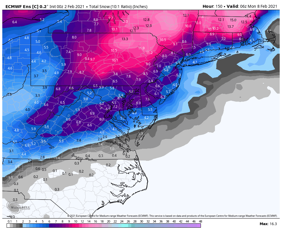
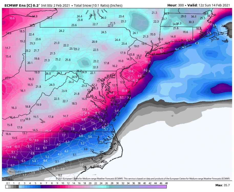
Both maps are 10:1 SRs... there is no Kuchera for the control FYI This weekend After the 12th-14th storm moves through
-
Jan 31st - 33rd Storm Obs and Disco like it's 1979
yoda replied to Bob Chill's topic in Mid Atlantic
awhile lol. I was out doing a Jebwalk between 1-2am and it was coming down nicely then as well -
Feb Long Range Discussion (Day 3 and beyond) - MERGED
yoda replied to WinterWxLuvr's topic in Mid Atlantic
06z GFS misses with this weekend... but then has a parade of 3 waves/storms from the 11th to the 16th lol -
Feb Long Range Discussion (Day 3 and beyond) - MERGED
yoda replied to WinterWxLuvr's topic in Mid Atlantic
FWIW, 00z EURO control run is on board for Sunday for a 4-8" event -- then in the 12th to 14th time period blasts us with another major snowstorm -
Feb Long Range Discussion (Day 3 and beyond) - MERGED
yoda replied to WinterWxLuvr's topic in Mid Atlantic
Was it phasing in with the SLP on the 12z run and that's how we got the mega snows? Or am I wrong and it was something completely different that caused that? -
Feb Long Range Discussion (Day 3 and beyond) - MERGED
yoda replied to WinterWxLuvr's topic in Mid Atlantic
LWX morning AFD discussing the Sunday potential... even talks about dangerously low wind chills possible on Monday -
Jan 31st - 33rd Storm Obs and Disco like it's 1979
yoda replied to Bob Chill's topic in Mid Atlantic
Looks like there is a streamer in FFX county intensifying in radarscope -
Feb Long Range Discussion (Day 3 and beyond) - MERGED
yoda replied to WinterWxLuvr's topic in Mid Atlantic
Euro doesn't have the 2nd storm that 12z did FWIW -
Jan 31st - 33rd Storm Obs and Disco like it's 1979
yoda replied to Bob Chill's topic in Mid Atlantic
6 miles? Wow lol Just finished my 3 mile walk... felt real nice and invigorating. Love watching the snow fall at night in the streetlights -
Feb Long Range Discussion (Day 3 and beyond) - MERGED
yoda replied to WinterWxLuvr's topic in Mid Atlantic
986mb 00z Mon by ACY lol... long week of tracking once again lol -
Jan 31st - 33rd Storm Obs and Disco like it's 1979
yoda replied to Bob Chill's topic in Mid Atlantic
Going on a Jebwalk at 1am with no cars and just the lights and falling snow... very nice. Apparently some wind too as well -
Feb Long Range Discussion (Day 3 and beyond) - MERGED
yoda replied to WinterWxLuvr's topic in Mid Atlantic
CMC is also a miss -
Feb Long Range Discussion (Day 3 and beyond) - MERGED
yoda replied to WinterWxLuvr's topic in Mid Atlantic
Always nice to see you posting more... thank you for dropping the snow weenie knowledge today lol