yoda
-
Posts
62,926 -
Joined
Content Type
Profiles
Blogs
Forums
American Weather
Media Demo
Store
Gallery
Everything posted by yoda
-
@high risk 18z NAM soundings have pretty impressive hodos from around 21z FRI to 03z SAT across the region... SBCAPE/MLCAPE are in the 200-400 range... but a little concerned about the TOR threat. SRH, along with low level and deep layer shear are pretty strong Hmmm... 21z FRI at KEZF is just not a good sounding (i.e. definite TOR signal there)
-
Good timing PUBLIC INFORMATION STATEMENT NATIONAL WEATHER SERVICE BALTIMORE MD/WASHINGTON DC 1154 AM EST TUE NOV 8 2022 ...NATIONAL WEATHER SERVICE WSR-88D WEATHER RADAR IN STERLING, VA PLANNED TO RETURN TO SERVICE BY WEDNESDAY EVENING... SINCE NOVEMBER 3, 2022, THE KLWX WSR-88D RADAR, OPERATED BY THE NATIONAL WEATHER SERVICE IN STERLING, VA, HAS BEEN DOWN FOR THE REPLACEMENT OF ITS EMERGENCY GENERATOR, FUEL TANKS, AND ACCOMPANYING COMPONENTS. THIS SCHEDULED MAINTENANCE IS RUNNING AHEAD OF SCHEDULE, AND THE RADAR IS EXPECTED TO RETURN TO SERVICE BY WEDNESDAY EVENING. OF COURSE AN ISSUE COULD STILL ARISE TO UNEXPECTEDLY DELAY THIS. THIS MAINTENANCE IS IMPORTANT TO SUPPORT THE RADAR’S OPERATION DURING PERIODS OF COMMERCIAL POWER OUTAGES, INCLUDING WHEN HAZARDOUS WEATHER IS PRESENT OR IN THE VICINITY. THIS GENERATOR UPDATE IS ONE OF FIVE MAJOR PROJECTS OF THE NEXRAD SERVICE LIFE EXTENSION PROGRAM, A SERIES OF UPGRADES AND REPLACEMENTS THAT WILL KEEP OUR NATION’S NETWORK OF RADARS VIABLE INTO THE THE NEXT DECADE. NOAA NATIONAL WEATHER SERVICE, THE UNITED STATES AIR FORCE, AND THE FEDERAL AVIATION ADMINISTRATION ARE INVESTING $150 MILLION IN THE SEVEN YEAR PROGRAM. THE FIRST PROJECT WAS THE INSTALLATION OF THE NEW SIGNAL PROCESSOR AND THE SECOND PROJECT WAS THE TRANSMITTER REFURBISHMENT. THE TWO REMAINING PROJECTS ARE THE REFURBISHMENT OF THE PEDESTAL AND EQUIPMENT SHELTERS. THE SERVICE LIFE EXTENSION PROGRAM WILL COMPLETE IN 2023. DURING THE DOWNTIME, WEATHER RADAR INFORMATION CAN BE GAINED FROM ADJACENT WSR-88D RADARS, INCLUDING: KDIX FT. DIX NJ KDOV DOVER DE KAKQ WAKEFIELD VA KFCX BLACKSBURG VA KRLX CHARLESTON WV KPBZ PITTSBURGH PA ADDITIONALLY, WEATHER RADAR INFORMATION CAN BE GAINED FROM NEARBY FAA TERMINAL WEATHER RADARS (TDWRS) LOCATED AT: TIAD WASHINGTON DULLES TDCA WASHINGTON NATIONAL TBWI BALTIMORE/WASHINGTON INTERNATIONAL TADW JOINT BASE ANDREWS FOR DIRECT ACCESS TO ANY OF THESE SURROUNDING RADAR SITES, GO TO THE FOLLOWING WEB PAGE: HTTPS://RADAR.WEATHER.GOV A SINGLE RADAR SITE CAN BE VIEWED BY GOING TO THE “SELECT VIEW” MENU OPTION THEN CLICKING ON “LOCAL RADAR” TO SELECT A SINGLE RADAR SITE. THE KLWX WSR-88D IS PART OF A NETWORK OF 159 OPERATIONAL RADARS. THE RADAR OPERATIONS CENTER IN NORMAN, OKLAHOMA, PROVIDES LIFECYCLE MANAGEMENT AND SUPPORT FOR ALL WSR-88DS. FOR A RADAR MOSAIC LOOP HTTPS://RADAR.WEATHER.GOV THE NATIONAL WEATHER SERVICE BALTIMORE/WASHINGTON WEATHER FORECAST OFFICE IN STERLING, VA CAN BE FOUND ON SOCIAL MEDIA AT @NWS_BALTWASH
-
Better let the NHC know then since their latest disco says barely any strengthening
-
There's not enough lulz for this post
-
MRGL risk of severe on Friday afternoon into Friday night per Day 3 SPC OTLK
-
00z GFS still drops 2-3 inches across much of VA from CHO to I95 corridor into C MD
-
Instability is below 500 J/KG... but those are some impressive looking hodos on the 00z NAM for Friday evening into early Saturday
-
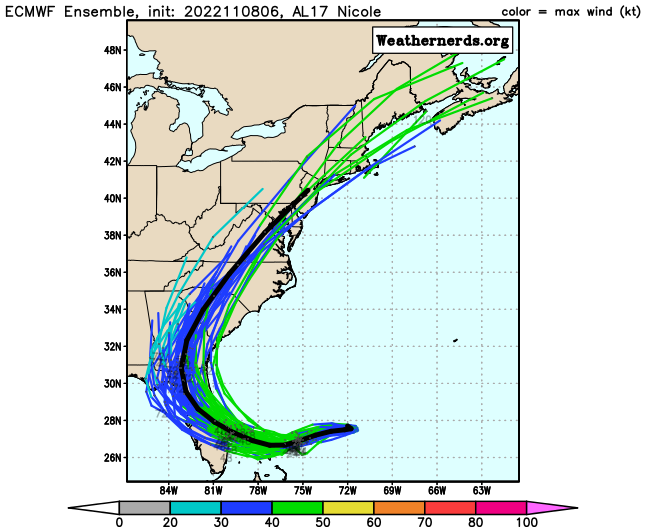
Tropical Storm Nicole Discussion Number 8 NWS National Hurricane Center Miami FL AL172022 1000 PM EST Tue Nov 08 2022 Nicole's satellite appearance has changed little since this afternoon. Deep convection is not very strong near the center of the cyclone at this time, and there appears to be some dry air intrusions into the circulation as evidenced by water vapor imagery. Nonetheless, wind and central pressure observations from NOAA and Air Force Hurricane aircraft indicate that the system is very close to hurricane strength and the current advisory intensity is set to 60 kt. Center fixes indicate that the cyclone is moving west-southwestward, or about 250/9 kt The track forecast philosophy is basically the same as in the previous advisory package. Nicole should move west-southwestward to westward, on the south side of an eastward-moving high pressure area, for the next 24 hours. Thereafter, the system should turn northwestward and then northward along the western side of the high. In 3-5 days, Nicole is likely to accelerate northeastward over the eastern United States, to the east of a large mid-level trough. The track model guidance has not changed significantly, nor has the official forecast. This is near the southern edge of the guidance suite for the next 1-2 days, and roughly in the middle of the guidance thereafter. Nicole will be moving over fairly warm SSTs of 27-28 degrees Celsius during the next day or so. However, the SHIPS guidance indicates that the vertical shear will be 25 kt or higher, with low-to mid-tropospheric humidities on the order of 50 percent, during the next 24 hours. Nicole is likely to become a hurricane soon but, given the marginal dynamic and thermodynamic environment, significant strengthening seems unlikely. The official intensity forecast is near or above the available model guidance, and closely follows the decay-SHIPS model after landfall. Weakening is expected after Nicole moves inland over Florida and Georgia and while it accelerates northeastward over the southeastern United States. The cyclone should complete extratropical transition by 72 hours and merge with another extratropical low near Atlantic Canada in 120 hours.
-
-
Afternoon AFD from LWX mentions severe weather threat LONG TERM /FRIDAY THROUGH TUESDAY/... The long term period will begin with remnants of Nicole moving north through our area. Recent guidance is trending quicker than in previous days which would bring rain to the area Friday morning and lasting throughout the day. Heavy rain on Friday could lead to isolated to scattered instances of flooding with PWAT values nearing and greater than 2 inches. The track of remnants of Nicole will determine the amount and location of rainfall. Nevertheless, guidance indicates high probabilities of over an inch of rain and up to 4 inches of rain for the area. While CAPE is limited (less than 150 J/kg), there will be upward to 50 knots of bulk shear over our area Friday afternoon making thunderstorms and severe weather possible.
-
12z CMC looks like 2 to 3 inches of rain for the majority of the LWX CWA 12z GFS has the heaviest rain a bit further west along the BR... 2 to 4 inches
-
I made it
-
-
Thread been give
-
None of the 12z models have Nicole reaching hurricane status
-
-
Day 10 Euro looks interesting...
-
5am nhc path has Nicole just to the east of DCA at 1am Saturday
-
Guess I will be buying some Powerball tickets lol
-
Fox5 DC winter outlook https://www.fox5dc.com/weather/winter-outlook-2022-2023-snow-blizzard-dmv-dc-maryland-virginia
-
FOX5 DC winter outlook https://www.fox5dc.com/weather/winter-outlook-2022-2023-snow-blizzard-dmv-dc-maryland-virginia