

yoda
-
Posts
63,653 -
Joined
Content Type
Profiles
Blogs
Forums
American Weather
Media Demo
Store
Gallery
Everything posted by yoda
-
Bow echo or bowing MCS would be nice
- 1,696 replies
-
- 4
-

-
- severe
- thunderstorms
- (and 5 more)
-
103/104 probably in play if clouds don't mess it up
-
Amazon prime days suck. Don't be ordering a whole bunch of stuff lol. I work at SDC1 now... basically like same day delivery station. Order it in the morning, get it in the afternoon. Going to be a long next few days
-
Heat Advisories up for tomorrow
-
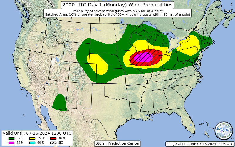
30% wind added in E NY into VT
-
-
And also Day 1
-
Severe Weather Statement National Weather Service Baltimore MD/Washington DC 434 PM EDT Mon Jul 15 2024 VAC107-152045- /O.CON.KLWX.SV.W.0140.000000T0000Z-240715T2045Z/ Loudoun VA- 434 PM EDT Mon Jul 15 2024 ...A SEVERE THUNDERSTORM WARNING REMAINS IN EFFECT UNTIL 445 PM EDT FOR NORTHEASTERN LOUDOUN COUNTY... At 434 PM EDT, a severe thunderstorm was located near Leesburg, moving east at 20 mph. HAZARD...70 mph wind gusts. SOURCE...Radar indicated. IMPACT...Damaging winds will cause some trees and large branches to fall. This could injure those outdoors, as well as damage homes and vehicles. Roadways may become blocked by downed trees. Localized power outages are possible. Unsecured light objects may become projectiles. Locations impacted include... Leesburg, Lansdowne, Purcellville, Hamilton, Paeonian Springs, Waterford, Lucketts, and Lincoln. PRECAUTIONARY/PREPAREDNESS ACTIONS... For your protection move to an interior room on the lowest floor of a building. To report severe weather contact your nearest law enforcement agency. They will send your report to the National Weather Service office in Sterling Virginia. Continuous cloud to ground lightning is occurring with this storm. Move indoors immediately. Lightning is one of nature`s leading killers. Remember, if you can hear thunder, you are close enough to be struck by lightning. && LAT...LON 3922 7746 3921 7747 3919 7748 3918 7751 3915 7753 3912 7752 3911 7749 3910 7748 3911 7772 3915 7773 3922 7769 3925 7749 TIME...MOT...LOC 2034Z 269DEG 18KT 3917 7758 THUNDERSTORM DAMAGE THREAT...CONSIDERABLE HAIL THREAT...RADAR INDICATED MAX HAIL SIZE...<.75 IN WIND THREAT...RADAR INDICATED MAX WIND GUST...70 MPH
-
Looks like a tie at BWI
-
100 at 4pm reported at both FDK and Cumberland MD
-

2024 Short/Medium Range Severe Weather Discussion
yoda replied to Chicago Storm's topic in Lakes/Ohio Valley
-
2024 Short/Medium Range Severe Weather Discussion
yoda replied to Chicago Storm's topic in Lakes/Ohio Valley
Regular URGENT - IMMEDIATE BROADCAST REQUESTED Severe Thunderstorm Watch Number 539 NWS Storm Prediction Center Norman OK 320 PM CDT Mon Jul 15 2024 The NWS Storm Prediction Center has issued a * Severe Thunderstorm Watch for portions of Central and Eastern Iowa Northwest Illinois Northeast Missouri Southwest Wisconsin * Effective this Monday afternoon and evening from 320 PM until 1100 PM CDT. * Primary threats include... Widespread damaging winds and isolated significant gusts to 85 mph likely Scattered large hail likely with isolated very large hail events to 2.5 inches in diameter possible A tornado or two possible SUMMARY...Intense thunderstorms will soon develop across Iowa in a very moist and unstable air mass. Activity will track eastward and organize into a fast-moving bowing cluster, capable of very damaging wind gusts and large hail. A tornado or two is also possible across this region. The severe thunderstorm watch area is approximately along and 85 statute miles north and south of a line from 25 miles west of Des Moines IA to 5 miles east southeast of Rockford IL. For a complete depiction of the watch see the associated watch outline update (WOUS64 KWNS WOU9). PRECAUTIONARY/PREPAREDNESS ACTIONS... REMEMBER...A Severe Thunderstorm Watch means conditions are favorable for severe thunderstorms in and close to the watch area. Persons in these areas should be on the lookout for threatening weather conditions and listen for later statements and possible warnings. Severe thunderstorms can and occasionally do produce tornadoes. && -
BWI at 101 at 4pm obs DCA 99 IAD 98
-
3 STWs up from LWX right now
-
2024 Short/Medium Range Severe Weather Discussion
yoda replied to Chicago Storm's topic in Lakes/Ohio Valley
Day 1 Convective Outlook NWS Storm Prediction Center Norman OK 0300 PM CDT Mon Jul 15 2024 Valid 152000Z - 161200Z ...THERE IS A MODERATE RISK OF SEVERE THUNDERSTORMS ACROSS PORTIONS OF EASTERN IOWA...EXTREME SOUTHERN WISCONSIN...NORTHERN ILLINOIS...AND FAR NORTHWEST INDIANA... ...THERE IS A SLIGHT RISK OF SEVERE THUNDERSTORMS ACROSS PORTIONS OF THE CENTRAL PLAINS...AND ACROSS PARTS OF NEW YORK...PENNSYLVANIA AND FAR NORTHERN NEW JERSEY... ...SUMMARY... Severe thunderstorms are expected through this evening across portions of the Midwest, central High Plains, lower Great Lakes, and Arizona. The greatest potential for severe gusts is over eastern Iowa into Illinois and Indiana. ...Midwest... Both tornado and wind probabilities have been increased with the 20z update to 10 percent, and 45 percent SIG, respectively. Latest satellite imagery shows a modified outflow boundary draped across far eastern IA into northern IL. A very moist airmass with dewpoints in the mid/upper 70s amid strong heating is resulting in a corridor or strong to extreme instability across the region. Favorable vertical shear will support initial supercells, organizing into a bowing MCS with time as low-level flow remains orthogonal to the developing band of storms. The greatest severe wind potential is expected along the instability gradient in the vicinity of the remnant outflow boundary, extending from far eastern IA into extreme southern WI, northern IL, and far northwest IN into this evening. Widespread gusts of 60-70 mph are expected, with some gusts to 85 mph possible. Given favorable low-level shear, mesovortex tornadoes are likely along and near the apex of the developing bow late this afternoon into evening. For short term details on severe potential across this area, reference MCD 1630. -
2024 Short/Medium Range Severe Weather Discussion
yoda replied to Chicago Storm's topic in Lakes/Ohio Valley
-
2024 Short/Medium Range Severe Weather Discussion
yoda replied to Chicago Storm's topic in Lakes/Ohio Valley
-
Looks like 98 at both DCA and BWI at 1pm... 95 at IAD
-
URGENT - WEATHER MESSAGE National Weather Service Baltimore MD/Washington DC 1255 PM EDT Mon Jul 15 2024 DCZ001-MDZ006-008-011-013-014-016>018-504-506>508-VAZ053>055-057- 527-160100- /O.UPG.KLWX.EH.A.0005.240716T1500Z-240717T0000Z/ /O.NEW.KLWX.EH.W.0007.240716T1500Z-240717T0000Z/ /O.CON.KLWX.EH.W.0006.000000T0000Z-240716T0000Z/ District of Columbia-Northern Baltimore-Cecil-Southern Baltimore- Prince Georges-Anne Arundel-Charles-St. Marys-Calvert- Central and Southeast Montgomery-Central and Southeast Howard- Northwest Harford-Southeast Harford-Fairfax- Arlington/Falls Church/Alexandria-Stafford-King George- Central and Southeast Prince William/Manassas/Manassas Park- Including the cities of Washington, Reisterstown, Cockeysville, Elkton, Baltimore, Bowie, Suitland-Silver Hill, Clinton, College Park, Greenbelt, Laurel, Camp Springs, Glen Burnie, Annapolis, Severn, South Gate, Severna Park, Arnold, Odenton, St. Charles, Waldorf, Lexington Park, California, Chesapeake Beach, Huntingtown, Dunkirk, North Beach, Lusby, Prince Frederick, Bethesda, Rockville, Gaithersburg, Silver Spring, Columbia, Ellicott City, Jarrettsville, Aberdeen, Reston, Herndon, Annandale, Centreville, Chantilly, McLean, Franconia, Arlington, Alexandria, Falls Church, Falmouth, Dahlgren, Dale City, Manassas, Woodbridge, Lake Ridge, and Montclair 1255 PM EDT Mon Jul 15 2024 ...EXCESSIVE HEAT WARNING REMAINS IN EFFECT UNTIL 8 PM EDT THIS EVENING... ...EXCESSIVE HEAT WARNING IN EFFECT FROM 11 AM TO 8 PM EDT TUESDAY... * WHAT...During the Excessive Heat Warnings, dangerously hot conditions with heat index values around 110 expected. * WHERE...Portions of central, northeast, northern and southern Maryland, The District of Columbia and central and northern Virginia. * WHEN...For the first Excessive Heat Warning, until 8 PM EDT this evening. For the second Excessive Heat Warning, from 11 AM to 8 PM EDT Tuesday. * IMPACTS...Extreme heat and humidity will significantly increase the potential for heat related illnesses, particularly for those working or participating in outdoor activities. * ADDITIONAL DETAILS...Very warm and humid conditions will persist into the overnight hours, adding heat stress to those without air conditioning. Ensure to stay hydrated and find ways to stay cool.
-
100+ guaranteed
-
Downtown Minneapolis about to get rocked BULLETIN - EAS ACTIVATION REQUESTED Severe Thunderstorm Warning National Weather Service Twin Cities/Chanhassen MN 1236 AM CDT Sun Jul 14 2024 The National Weather Service in the Twin Cities has issued a * Severe Thunderstorm Warning for... Northwestern Hennepin County in east central Minnesota... East central Wright County in central Minnesota... * Until 100 AM CDT. * At 1235 AM CDT, a severe thunderstorm was located over Otsego, or 13 miles east of Buffalo, moving southeast at 35 mph. THIS IS A DESTRUCTIVE STORM FOR THE WESTERN TWIN CITIES METRO. HAZARD...Three inch hail and 60 mph wind gusts. SOURCE...Trained weather spotters. IMPACT...People and animals outdoors will be severely injured. Expect shattered windows, extensive damage to roofs, siding, and vehicles. * Locations impacted include... Brooklyn Park, Maple Grove, Champlin, Anoka, St. Michael, Otsego, Rogers, Albertville, Corcoran, Medina, Dayton, and Hanover. This includes Interstate 94 in Minnesota between mile markers 199 and 205. PRECAUTIONARY/PREPAREDNESS ACTIONS... For your protection move to an interior room on the lowest floor of a building. This is a dangerous storm. Prepare immediately for large destructive hail capable of producing significant damage. People outside should move to shelter inside a strong building, and stay away from windows. && LAT...LON 4527 9355 4524 9352 4524 9350 4523 9349 4521 9342 4514 9331 4505 9362 4526 9373 4530 9364 TIME...MOT...LOC 0535Z 319DEG 31KT 4525 9360 THUNDERSTORM DAMAGE THREAT...DESTRUCTIVE HAIL THREAT...OBSERVED MAX HAIL SIZE...3.00 IN WIND THREAT...RADAR INDICATED MAX WIND GUST...60 MPH
-
URGENT - WEATHER MESSAGE National Weather Service Baltimore MD/Washington DC 139 PM EDT Sat Jul 13 2024 DCZ001-MDZ004>006-008-011-013-014-016>018-503>508-VAZ037>040-050- 051-053>057-501-502-505-506-526-527-140145- /O.NEW.KLWX.EH.A.0004.240715T1500Z-240716T0000Z/ District of Columbia-Frederick MD-Carroll-Northern Baltimore- Cecil-Southern Baltimore-Prince Georges-Anne Arundel-Charles- St. Marys-Calvert-Northwest Montgomery- Central and Southeast Montgomery-Northwest Howard- Central and Southeast Howard-Northwest Harford-Southeast Harford- Albemarle-Greene-Madison-Rappahannock-Orange-Culpeper-Fairfax- Arlington/Falls Church/Alexandria-Stafford-Spotsylvania- King George-Northern Fauquier-Southern Fauquier-Western Loudoun- Eastern Loudoun-Northwest Prince William- Central and Southeast Prince William/Manassas/Manassas Park- Including the cities of Washington, Frederick, Ballenger Creek, Eldersburg, Westminster, Reisterstown, Cockeysville, Elkton, Baltimore, Bowie, Suitland-Silver Hill, Clinton, College Park, Greenbelt, Laurel, Camp Springs, Glen Burnie, Annapolis, Severn, South Gate, Severna Park, Arnold, Odenton, St. Charles, Waldorf, Lexington Park, California, Chesapeake Beach, Huntingtown, Dunkirk, North Beach, Lusby, Prince Frederick, Germantown, Damascus, Bethesda, Rockville, Gaithersburg, Silver Spring, Lisbon, Columbia, Ellicott City, Jarrettsville, Aberdeen, Charlottesville, Stanardsville, Madison, Orange, Gordonsville, Culpeper, Reston, Herndon, Annandale, Centreville, Chantilly, McLean, Franconia, Arlington, Alexandria, Falls Church, Falmouth, Fredericksburg, Dahlgren, Warrenton, Turnbull, Purcellville, Leesburg, Ashburn, Sterling, Haymarket, Dale City, Manassas, Woodbridge, Lake Ridge, and Montclair 139 PM EDT Sat Jul 13 2024 ...EXCESSIVE HEAT WATCH IN EFFECT FROM MONDAY MORNING THROUGH MONDAY EVENING... * WHAT...Dangerously hot conditions with heat index values up to 110 possible. * WHERE...Portions of central, north central, northeast, northern and southern Maryland, The District of Columbia and central, northern and northwest Virginia. * WHEN...From Monday morning through Monday evening. * IMPACTS...Extreme heat and humidity will significantly increase the potential for heat related illnesses, particularly for those working or participating in outdoor activities. * ADDITIONAL DETAILS...Very warm and humid conditions will persist into the overnight hours. Ensure to stay hydrated and find ways to stay cool. Another dangerously hot day is expected on Tuesday.
-
The forecast this morning was 88/89 I believe. It hit 97
-
Flood Watch National Weather Service Baltimore MD/Washington DC 224 PM EDT Fri Jul 12 2024 MDZ011-014-508-130230- /O.EXB.KLWX.FA.A.0016.000000T0000Z-240713T1400Z/ /00000.0.ER.000000T0000Z.000000T0000Z.000000T0000Z.OO/ Southern Baltimore-Anne Arundel-Southeast Harford- Including the cities of Glen Burnie, Annapolis, Baltimore, Severna Park, Odenton, Severn, Aberdeen, Arnold, and South Gate 224 PM EDT Fri Jul 12 2024 ...FLOOD WATCH IN EFFECT THROUGH SATURDAY MORNING... * WHAT...Flash flooding caused by excessive rainfall continues to be possible. * WHERE...Portions of central and northern Maryland, including the following areas, in central Maryland, Anne Arundel. In northern Maryland, Southeast Harford and Southern Baltimore. * WHEN...Through Saturday morning. * IMPACTS...Excessive runoff may result in flooding of rivers, creeks, streams, and other low-lying and flood-prone locations. Flooding may occur in poor drainage and urban areas. * ADDITIONAL DETAILS... - A couple rounds of heavy rainfall are likely this evening, and again late tonight into Saturday morning. Rainfall amounts will average around 1 to 3 inches with localized amounts around 3 to 4 inches possible. - Please visit www.weather.gov/safety/flood for flood safety and preparedness information
