Dunkman
-
Posts
2,114 -
Joined
-
Last visited
Content Type
Profiles
Blogs
Forums
American Weather
Media Demo
Store
Gallery
Everything posted by Dunkman
-
I feel really bad for the people in the upstate who have to watch the HRRR slowly take their nice band of snow away run by run today.
-
The NAM is really good at showing every possible solution over the course of a couple days regardless of how based in reality they may or may not be.
-
It’ll get here at the end of March like it always does. Seriously though as has been said the cold holding back like this is not at all unusual. And it does usually get here eventually. It’s just torture after some of the runs this week.
-
This is another miss in the Triad. Such a rough winter. I’ve seen snow half a dozen times and it hasn’t totaled a half inch.
-
The HRRR could be right of course. That said it’s shown very little skill outside of 6-8 hours this winter from what I’ve seen. I wouldn’t worry too much.
-
Why do you say that? At least in central NC it’s pretty typical.
-
Yeah the 3k NAM cut back on what it was showing in central NC for tomorrow as well. I think there will be flurries flying around but that may be about it.
-
That band in the mountains looks really stout if you user a higher tilt from GSP. (You can see all the snow that’s falling but not making it to the ground.)
-
I found some slides on FRAM which were mostly what I was looking for. One interesting thing is there wasn't much evidence of temps below -2C helping with ice accrual. At that point it seemed like rates and even wind were bigger factors. https://vlab.ncep.noaa.gov/documents/10157/137122/FRAM_VLAB_Presentation.pdf/50ff7877-c52d-80f4-1413-b294db7710e9
-
I mean the accrual is going to be a small fraction of what the models are showing with temps hovering around freezing. I'd be interested if there was some type of ZR accrual guide based on temps and precipitation rate.
-
Looking through the UK temp panels I don't think any of that in NC in the Triad or points south and east is snow. Maybe a few flakes before going to a little sleet, some marginal ZR and then rain. Even farther N and W most of it is mixed. As you get into Virginia it looks more likely to stay snow.
-
I’m honestly surprised the Euro totals aren’t higher up north. The coastal just sits there for 2 days.
-
Pretty excited for everyone to my east to get snow tonight and everyone to my west to get it this weekend. Why haven't I moved to Colorado yet?
-
He’s been pretty anti-weenie for awhile now. I think the terrible winters have broken him.
-
Pretty sure this storm is gonna be in Boston by Monday.
-
It failed everywhere outside of the northern mountains it seems. Storm just unraveled.
-
It’s been a pretty miserable performance for the Euro which had most of NC bone dry yesterday. Shifting the precip 150 miles north inside of the last 48 hours is not ideal.
-
Thanks for dropping in to explain your thinking on this Disc! Regardless of what happens with this one it's exciting to have an active winter pattern for a change.
-
Built up frustration? I haven’t had more than a glorified dusting since 2018. It sucks.
-
Have we punted on January yet? Gotta be close...
-
Are you sure we're allowed to have a good pattern heading into January? That doesn't seem right.
-
I compared the digital accumulation to a couple sites and it was underestimating precip by as much as 50%. I assume due to the tropical nature of the rain. The shelter in place unless fleeing from flooding FFW was not a welcome sight this morning. Most of the rivers in the Greensboro metro are above flood stage now and Charlotte looks a lot worse.
-
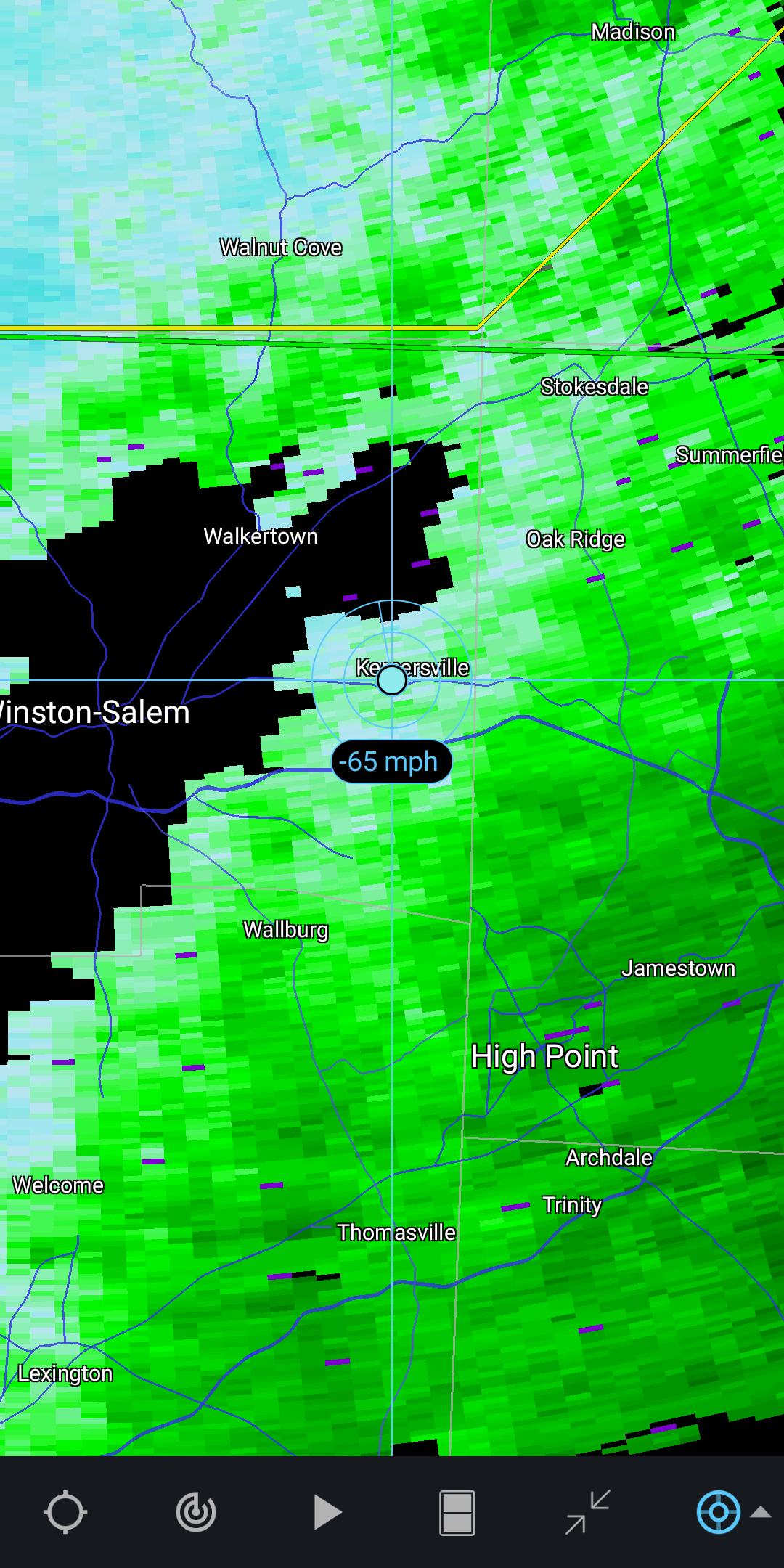
This cell cutting through the Triad is looking nastier all the time. And a little bit suspicious. Wouldn't be shocked to see a warning go up.
-
I would imagine the action is about to pick up. We saw our worst winds in those broken up looking light showers.
-
Looks like you have the last band of heavy wind over you right now. Should get better soon I think?