Dunkman
-
Posts
2,115 -
Joined
-
Last visited
Content Type
Profiles
Blogs
Forums
American Weather
Media Demo
Store
Gallery
Everything posted by Dunkman
-
12z UK went well north of Wilmington.
-
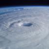
It doesn't look like any models really want to strengthen the storm much from here on in which would certainly be a blessing. That said, satellite is looking better all the time.
-
GFS and getting a clue 3 days late. Name a more iconic duo.
-
950mb/130mph at 11am. I'm a little surprised they didn't bump the winds back up to 140 given what recon found but it hardly matters.
-
Looking at the Euro ensemble tracks from 00z it's almost as if they smoothed out the tracks that many of the other models are seeing. Like instead of going NW until off of ILM and then due west the EPS just goes WNW the entire time and ends up in more or less the same spot after 120-144h.
-
Yeah it could have been COAMPS instead of HMON. Those are the models they used last year. For some reason I thought they had tweaked it this year but I've been trying to find where I saw it and can't so there's a good chance I just imagined it.
-
Just to add, I believe for 2018 the TVCN is equally weighted GFS, ECMWF, UKMET, HWRF and HMON. (I actually can't find where I saw that but I think that's what I remember reading)
-
I posted this in the main thread as well but recon just found 165 mph flight level winds in the NE quad. Was definitely hoping the ewrc had dropped the winds more than this.
-
I don't trust the NAM, or really anything outside of the operational EC, UK and GFS, to have any chance to resolve this complicated steering pattern. Even if the NAM does stumble into an ultimately correct solution it's probably more of a broken clock being right twice a day scenario.
-
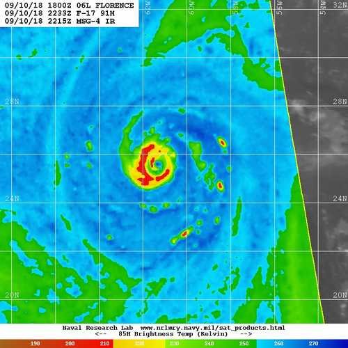
I posted this in the main thread as well but from the mw pass a couple hours ago it does look like some definitely core reorganization going on. I don't know if I'd call it a full eyewall replacement but there's a secondary maxima on at least half of the storm.
-
Point stands though it's still a large spread at 84 hours.
-
Ragged? And no eyewall replacement cycle. It just developed a proper eyewall recently.
-
Exactly this. Actually the TVCN consensus model has been beating even the official NHC forecast tracks recently. Similarly, the IVCN consensus is the best bet for intensity. As for the GFS, I really think it's just missing on the strength of that ridge. Be nice if the GFS got one right for a change though.
-
So those WPC forecasts aren't entirely automated but they do lean heavily on the GEFS and NCEP numerical models.
-
NOAA "Kermit" was supposed to take off at 12z from Bermuda for a mission. Awfully hard to get recon into this storm (although that should change today).
-
Landfall at like MHC and a slow drift and stall up to the NC/VA line is going to inundate the DC area with much of the rain that the Euro has going into central and western NC. And the DC area, as you know I'm sure, has had a ton of rain already in the last couple months. It's on the northern edge of the danger area for sure but definitely still in it.
-
The NC coast can take a hurricane. This isn't the northeast. People know what to do. There will probably be a lot of damage but they'll be ok. I'm expecting the rain to end up being much more dangerous than surge or wind.
-
With Floyd in the history books this seems a little premature.
-
I think there's a good chance that the weather will be ok at 5pm Thursday in Raleigh. The problem is that there are a lot of other factors in play. You don't want to get a flight crew stuck there, or a plane. And cancelled flights in other locations may also have an impact. I'd definitely take the earlier flight if you can.
-
Yeah the SSTs support at least a category higher than normal, probably more than that in spots. Strong category 3 is usually the worst case scenario for NC but I'm not sure that's the case this time.
-
Starting to look like it's just not our year triad north and west. Maybe I'll squeeze out 1" to add to my 1.5" season total.
-
Hard to get excited about the incoming flizzard when sitting at 1.5" for the winter so far. Need more than that here!
-
Who could have guessed that a SW wind would be bad for cad?
-
So I shouldn't say this but as soon as I saw reports of 6" from CHS the first thing I thought was how long has it been since Raleigh had 6" of snow? Was it this decade?
-
Beam height. It's not snowing anywhere near the surface to your west. The 0.5° scan is 3000 feet above the surface in Sanford, which is the closest location to the radar site that's actually showing a return.