wncsnow
-
Posts
8,828 -
Joined
-
Last visited
Content Type
Profiles
Blogs
Forums
American Weather
Media Demo
Store
Gallery
Everything posted by wncsnow
-

2023-2024 Fall/Winter Mountain Thread
wncsnow replied to The Alchemist's topic in Southeastern States
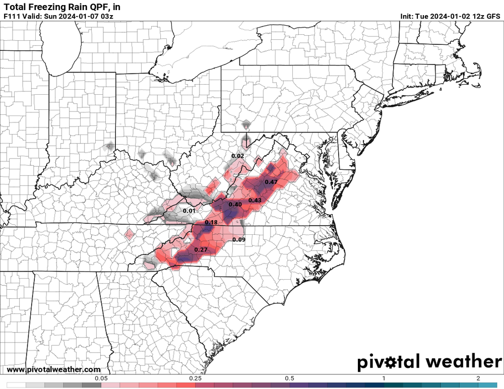
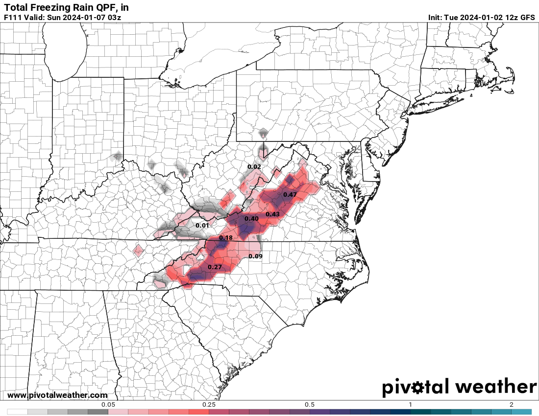
RDPS still showing a lot of ice for CAD favored areas. This is likely overdone but there is potential for .25-.50 for CAD favored areas north of 40 near the Blue Ridge. Of course some of it could be sleet there too. -
ICE totals going up on the NAM. I do think some of it will be sleet though.
-
2023-2024 Fall/Winter Mountain Thread
wncsnow replied to The Alchemist's topic in Southeastern States
NAM coming in with a lot more ZR -
2023-2024 Fall/Winter Mountain Thread
wncsnow replied to The Alchemist's topic in Southeastern States
We already have one -
2023-2024 Fall/Winter Mountain Thread
wncsnow replied to The Alchemist's topic in Southeastern States
20 at the house this morning. Here are some pros and cons for the upcoming system- Pros: 1.Timing- With the faster timing, it looks like most of the moisture will fall during Friday night starting sometime after midnight. This will maximize what cold air we do have. 2.Track- Most models have gotten rid of any TN valley low and have a southern track. This will diminish the WAA and keep CAD areas colder. 3. Confluence- Models have trended slightly colder mainly due to better confluence to the NE and a slightly stronger high. We want to see that continue with todays runs. Cons: 1. Lack of true CAD- This is always a big issue east of the Blue Ridge. We can get wintry precip with InSitu CAD but its rare. 2. Lack of moisture- Models are keeping this system weaker with less heavy precip for WNC. This could lead to freezing drizzle and it might accrue better but we need a heavy front end thump to get a few inches of snow and sleet. 3. The Pacific- The Pac has been a pain all winter and really the past 3 or 4 winters it has not been on our side at all. We need the N Pac ridge to move/dissipate. There is a ton of energy coming from the Pacific still which can be good but with the -PNA its always going to be a thread the needle type of situation. -
It's showing a front end of snow and sleet for the mountains and immediate foothills.
-
UK shifted 50 to 75 miles SE. It now has a lot more wintry precip in WNC. Basically none at 12Z.
-
2023-2024 Fall/Winter Mountain Thread
wncsnow replied to The Alchemist's topic in Southeastern States
I think some of this would be sleet and ZR but this is a big shift. Another shift or 2 and it might be game on -
2023-2024 Fall/Winter Mountain Thread
wncsnow replied to The Alchemist's topic in Southeastern States
UK is best its been yet and further south. -
2023-2024 Fall/Winter Mountain Thread
wncsnow replied to The Alchemist's topic in Southeastern States
GFS and Canadian both look decent guys. This ones not over yet! Keep that primary to the south and we got a shot IMO. -
GFS continuing the trend of South and weaker. I really think we might sneak an advisory level maybe even warning event above 3k north of 40. Inch or 2 of sleet and snow with .10-.25 ZR
-
2023-2024 Fall/Winter Mountain Thread
wncsnow replied to The Alchemist's topic in Southeastern States
RDPS looks more what I expect. Lots of sleet near the Blue Ridge north of 40 for the first few hours of precip. It's a good short range model usually. Although this is at the end of the run. -
2023-2024 Fall/Winter Mountain Thread
wncsnow replied to The Alchemist's topic in Southeastern States
The WAA is crazy on the NAM but it's way out at the end of the run. It goes from 26 with a dewpoint of 18 to 33 wetbulbed with rain falling within 6-8 hours. -
2023-2024 Fall/Winter Mountain Thread
wncsnow replied to The Alchemist's topic in Southeastern States
The NAM (I know) has AVL at 26 with a dewpoint of 18 Friday night around midnight. If that verifies before the moisture moves it, it will be difficult to get above freezing especially in CAD areas. -
It's snowed plenty of times in Raleigh in February.
-
Near normal is ok
-
It's not showing as cold now for first week in February?
-
2023-2024 Fall/Winter Mountain Thread
wncsnow replied to The Alchemist's topic in Southeastern States
The QPF is drying up on most models. Trended weaker for sure. -
2023-2024 Fall/Winter Mountain Thread
wncsnow replied to The Alchemist's topic in Southeastern States
Has ice still. Just not much moisture -
Southeast Sanitarium - Winter 23/24 Edition
wncsnow replied to eyewall's topic in Southeastern States
Get your boats and kayaks ready -
2023-2024 Fall/Winter Mountain Thread
wncsnow replied to The Alchemist's topic in Southeastern States
Hi Res NAM showing a little something too. More than it has thus far. -
2023-2024 Fall/Winter Mountain Thread
wncsnow replied to The Alchemist's topic in Southeastern States
NAM trying to show love again tomorrow for N GA and SW NC -
The latest Euro isn't as bad but its still a lot of cutters. Hopefully after the 15th or so it will finally transition to a better pattern. I'm in wait and see mode though.
-
Canadian
-
ZR Threat might be increasing