

wncsnow
-
Posts
8,827 -
Joined
-
Last visited
Content Type
Profiles
Blogs
Forums
American Weather
Media Demo
Store
Gallery
Everything posted by wncsnow
-

2023-2024 Fall/Winter Mountain Thread
wncsnow replied to The Alchemist's topic in Southeastern States
I'm not there yet but its concerning. The Pacific is still ruining our snow chances. I hope we can at least get a few inches of slop before the downpours this Saturday morning. -
2023-2024 Fall/Winter Mountain Thread
wncsnow replied to The Alchemist's topic in Southeastern States
The long range Op Euro is a disaster. I hope it's incorrect -
Flooding might be the big story
.thumb.png.f19ecacf09d3150712ee14259b3696ef.png)
-
2023-2024 Fall/Winter Mountain Thread
wncsnow replied to The Alchemist's topic in Southeastern States
It does try to give a few inches of snow before the monsoon. It's going to rain a lot the next 10 days. That seems for certain..thumb.png.2e5581a5a5167abfec8f35301b78af4f.png)
.thumb.png.e535c6a0fad5f4209a29c709ccc53285.png)
-
2023-2024 Fall/Winter Mountain Thread
wncsnow replied to The Alchemist's topic in Southeastern States
It's super amped. Yikes even for most of VA -
2023-2024 Fall/Winter Mountain Thread
wncsnow replied to The Alchemist's topic in Southeastern States
First ZR signature I've really seen from the GFS. It's really close in CAD areas for ice or snow depending on the warm nose.thumb.png.71d0439dcdea71da3fdc775930974991.png)
-
2023-2024 Fall/Winter Mountain Thread
wncsnow replied to The Alchemist's topic in Southeastern States
We need to get rid of this -PNA. If not its going to be rain, get cold, warm up, rain, get cold, warm up, rain. Aka our normal winter pattern most years. -
2023-2024 Fall/Winter Mountain Thread
wncsnow replied to The Alchemist's topic in Southeastern States
GEFS looks pretty warm too. -
2023-2024 Fall/Winter Mountain Thread
wncsnow replied to The Alchemist's topic in Southeastern States
-
2023-2024 Fall/Winter Mountain Thread
wncsnow replied to The Alchemist's topic in Southeastern States
GFS is no bueno for most on the 2nd system. Drives the low into east TN. Less snow than Euro -
Those in the Blue Ridge above 3k have a pretty good shot at 3-6 inches as it stands.
-
2023-2024 Fall/Winter Mountain Thread
wncsnow replied to The Alchemist's topic in Southeastern States
Canadian is more amped. Euro will be interesting to say the least. -
2023-2024 Fall/Winter Mountain Thread
wncsnow replied to The Alchemist's topic in Southeastern States
Ends up being decent but super close to a big hit -
2023-2024 Fall/Winter Mountain Thread
wncsnow replied to The Alchemist's topic in Southeastern States
Rain changes to snow at the end here. I really like the trends. Keep that low to the south and keep improving that confluence and we could be in business. -
2023-2024 Fall/Winter Mountain Thread
wncsnow replied to The Alchemist's topic in Southeastern States
Track is much better but just not cold enough for most. -
2023-2024 Fall/Winter Mountain Thread
wncsnow replied to The Alchemist's topic in Southeastern States
Early on, this looks like it might be a good run for the mountains on the GFS. More confluence in the NE. -
2023-2024 Fall/Winter Mountain Thread
wncsnow replied to The Alchemist's topic in Southeastern States
Latest Nam is close but not enough for most of us. North GA looks to be in the best spot for a car topper. -
Which week would that be?
-
2023-2024 Fall/Winter Mountain Thread
wncsnow replied to The Alchemist's topic in Southeastern States
I do think we may have a legit threat around MLK day. And this Wednesday night/Thursday could be sneaky and give NE GA and SWNC a few inches if that finger of precip develops that some of the models are hinting at. I think the 7th and the storm after that will be a lot of cold rain but as others said, it will help build snowpack to the northwest and northeast. I would love to see some signs of CAD in the long range. It is one of the few things that can destroy a SE Ridge. -
2023-2024 Fall/Winter Mountain Thread
wncsnow replied to The Alchemist's topic in Southeastern States
NW trend for the win? -
2023-2024 Fall/Winter Mountain Thread
wncsnow replied to The Alchemist's topic in Southeastern States
Yes you did. Hopefully it won't turn into too much of a good thing -
The thought did cross my mind..I just hope we get one good area wide storm.
-
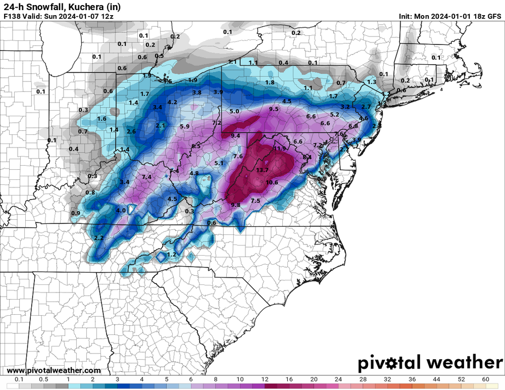
Uhm I thought the Midwest and Ohio Valley saw less snow during an El Nino? This looks more like a La Nina clown map
-
2023-2024 Fall/Winter Mountain Thread
wncsnow replied to The Alchemist's topic in Southeastern States
Next rainstorm a few days later -
2023-2024 Fall/Winter Mountain Thread
wncsnow replied to The Alchemist's topic in Southeastern States
Well the Euro does give the high mountains a couple inches of wet snow before transitioning to rain. It's basically showing a Miller B now.

.png.9333498522975630d4ed265ec81a1237.png)

.png.07ab4f71853694231da4c7c66f811f59.png)
.png.147d38011e1be9e0c8c47e9d0ebe48e2.png)
.png.b3e62e0d697feb170e0be8d86985ecf0.png)
