OSUmetstud
Meteorologist-
Posts
16,433 -
Joined
-
Last visited
Content Type
Profiles
Blogs
Forums
American Weather
Media Demo
Store
Gallery
Everything posted by OSUmetstud
-
SNE Tropical Weather Discussion - Hurricanes
OSUmetstud replied to USCAPEWEATHERAF's topic in New England
-
SNE Tropical Weather Discussion - Hurricanes
OSUmetstud replied to USCAPEWEATHERAF's topic in New England
It's now (unexpectedly) a cat 3 if anyone was paying attention lol. -
SNE Tropical Weather Discussion - Hurricanes
OSUmetstud replied to USCAPEWEATHERAF's topic in New England
There were several trapped under the ridge on yesterday's 12z but it went up a lot on the 00z run last night. Pretty big ensemble shift but that's why you don't make definitive forecasts for a storm 8 to 10 days out. I haven't seen much if any runs with a favorable northeast landfall synoptic look with a Midwest trough. But that could change. -
Has the AMO Flipped Phases?
OSUmetstud replied to raindancewx's topic in Weather Forecasting and Discussion
Klotzbach was mentioning the possibility of the AMO phase flipping last year. Their AMO calculation is different than CPC. -
Summer Banter, Observation and General Discussion 2018
OSUmetstud replied to CapturedNature's topic in New England
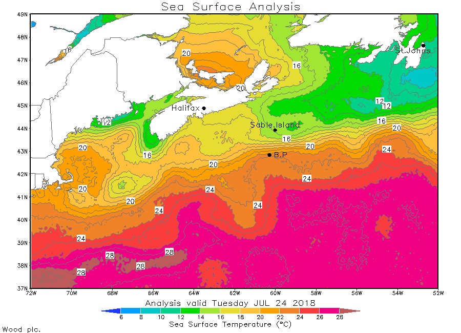
Yeah. The Gulf of St Lawrence is really shallow and not part of the westward extension of the Labrador current. It heats up readily in the summer and freezes in the winter. Its been very warm in Atlantic canada -
Summer Banter, Observation and General Discussion 2018
OSUmetstud replied to CapturedNature's topic in New England
On the large scale, Georges Bank is part of a very long coastal current system which flows southwestward from Laborador to the Mid-Atlantic Bight (Figure 4; Chapman and Beardsley, 1989). Locally, two oceanic water masses and local air/sea interaction determine the hydrographic conditions within the Gulf of Maine and on Georges Bank (Bigelow, 1926). Cold, low salinity coastal water enters the Gulf of Maine from the Scotian Shelf (Smith, 1983) and warm, saline Slope Water enters through the Northeast Channel (Ramp et al., 1985). Both of these inflows to the Gulf exhibit significant seasonal and inter-annual variability. The two water masses plus local runoff mix during a generally cyclonic (counterclockwise) movement around the Gulf which may slow down or even reverse in part during winter (Brown and Irish, 1992). During the summer, this basin-scale movement may be comprised of smaller-scale cyclonic flows around Jordan, Wilkinson, and Georges Basins (Brooks, 1985, Butman and Beardsley, 1991). In the western Gulf of Maine, near-surface waters flow both southward around Nantucket Shoals into the Mid-Atlantic Bight and eastward onto the northwest flank of Georges Bank (Hopkins and Garfield, 1981; Limeburner and Beardsley, 1982; Beardsley et al., 1991). On the northwest flank, the interaction of strong tidal currents and steep bottom topography results in a strong horizontal density front and a narrow, jet-like current flowing eastward along the northern edge of the Bank (Loder, 1980; Magnell et al., 1980; Butman, 1982). The flow then turns clockwise and slows to move southwestward along the southern flank of the Bank. The strength of this anticyclonic (clockwise) circulation increases with increasing stratification in the spring and summer (Butman et al., 1987). A permanent hydrographic front along the southern edge of the Bank separates the shelf water over the Bank from the more saline Slope Water offshore (Flagg, 1987). Much of the shelf water flowing southwestward along the southern flank of the Bank continues westward into the Mid-Atlantic Bight (Beardsley et al., 1985). During stratified conditions, some of the shelf water on the southern flank of the Bank moves northward through the Great South Channel, forming a partially closed gyre (Butman and Beardsley, 1987). http://www.usglobec.org/reports/nwaip/nwaip.chapter4.3.html I think that answers my question. But it still difficult to conceptualize without more imagery. -
Summer Banter, Observation and General Discussion 2018
OSUmetstud replied to CapturedNature's topic in New England
I'm not really up on my physical oceanography. Why are the water temperatures colder over the shallower Georges Bank and the Nantucket Sound than they are in deeper water sections of the Gulf of Maine? -
BUF's is cold Sunday I believe (Jan 17th 1982). -37F. Also the week before set the record for the lowest wind chill for an NFL game...the AFC Championship game in Cincy "Freezer Bowl" on jan 10th 1982.
-
Ensembles are between St. John's and the Grand Banks..moved east over the last 3 days, out of your hood for almost certain.
-
pretty much steady-state on the latest pass. 107 kt peak unflagged sfmr and flight level winds to 121 kts in the ne quad.
-
Those mike ventrice corrected ensemble probabilities for hurricane force winds in nyc look to be working out really well.
-
They found 106 kt sfmr in the ne eyewall on latest pass not sure if theyll increase the winds on the next forecast.
-
Its a closed wall on recon at 38 nm. U really need to stop.
-
Yeah i think this is true. I feel like things got worse for san juan with the new dominant oew not better.
-
Of course they didnt get 5 winds at landfall since it wasnt a 5...
-
They were removed enough from the landfall location that the wind should have weakened by the time the maximum winds reached them.
-
It didnt make landfall there.
-
These probabilities seem incredibly unrealistic


.png.e13d5c4e3ae64c31637d364a47fa197b.png)
.png.ea0be6b10a505c94dd4ea9e28c43ac50.png)


.gif.44a4b9802b28c14da235f71f57ca78df.gif)