Tatamy
-
Posts
2,572 -
Joined
-
Last visited
Content Type
Profiles
Blogs
Forums
American Weather
Media Demo
Store
Gallery
Everything posted by Tatamy
-
There was 17” inches where I was. I was a junior in HS at the time and had never seen something of that nature that I was old enough to remember. The 70s and 80s were lean times for snow lovers in the NY area. Snow changed to mixed precipitation during the day before it ended. My only source of weather info at the time was WINS and WCBS plus TV news at night. People have it so much better today.
-
I got 30” on LI
-
I do the same thing in my yard. Even with pre-existing snow cover you can usually find an ice crust on its top under the new snow cover in order to obtain a measurement.
-
We are getting a burst of light snow now. I would agree with it producing a coating to a half inch in places.
-
Back and forth between heavy sleet and snow. 9.5” total. 8/6
-
Have been going between heavy sleet and snow. Storm total 9.5”. 8/6
-
Snow/Sleet mixture here as well. 9/7
-

E PA/NJ/DE Winter 2025-26 Obs/Discussion
Tatamy replied to LVblizzard's topic in Philadelphia Region
Heavy sleet in Bethlehem Twp. 9/8. Snow/sleet total so far 8.5” -
8.5” with heavy sleet. Transitioned at 13:10. 9/8
-
Snow mixed with some sleet pellets here in Bethlehem Twp. 9/6
-
Up to 7” here. Watching the sleet line approach from Berks Cty.
-
Up to 7” now. Sleet line should be here within the hour.
-
It’s actually set up on a line currently extending from Baltimore to Dover and over Delaware Bay.
-
Storm total now up to 3”. 9/6. Visibility 1/4 mile.
-
Extreme Cold, Snow & Sleet: SECS 1/24 - 1/26
Tatamy replied to TriPol's topic in New York City Metro
Changeover line is in southern DE. -
Update: Heavy snow; Visibility 1/4 mile
-
Light snow; 9/6. Visibility 3/4 mile; 1 1/2” new
-
Extreme Cold, Snow & Sleet: SECS 1/24 - 1/26
Tatamy replied to TriPol's topic in New York City Metro
It’s being retired. -
Extreme Cold, Snow & Sleet: SECS 1/24 - 1/26
Tatamy replied to TriPol's topic in New York City Metro
Model outputs that I have been seeing show the snow arriving as light in the predawn hours Sunday and then ramping up. Regarding the GPS do you really think it will verify? -
Extreme Cold, Snow & Sleet: SECS 1/24 - 1/26
Tatamy replied to TriPol's topic in New York City Metro
Big time surge of Arctic air this evening. Temperature has dropped 25 degrees since mid-afternoon. Down to 10 with a DP of-10 -
Extreme Cold, Snow & Sleet: SECS 1/24 - 1/26
Tatamy replied to TriPol's topic in New York City Metro
Yeah Icon was fine. -
Extreme Cold, Snow & Sleet: SECS 1/24 - 1/26
Tatamy replied to TriPol's topic in New York City Metro
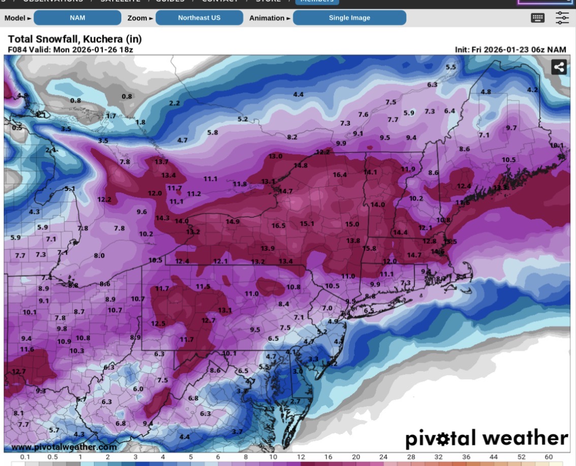
Check out the precip types on that model (RRFS). The totals shown do not match that or reflect the temperatures aloft. The snow totals are way overstated. They are basically another NAM - maybe worse. -
Extreme Cold, Snow & Sleet: SECS 1/24 - 1/26
Tatamy replied to TriPol's topic in New York City Metro
Where I was in the Lehigh Valley we had 5 degrees and pouring rain. I have never seen anything like that. -
Extreme Cold, Snow & Sleet: SECS 1/24 - 1/26
Tatamy replied to TriPol's topic in New York City Metro
Snowman - Totally agree. I am following the RDPS closely as that is another good Meso.
-
Extreme Cold, Snow & Sleet: SECS 1/24 - 1/26
Tatamy replied to TriPol's topic in New York City Metro
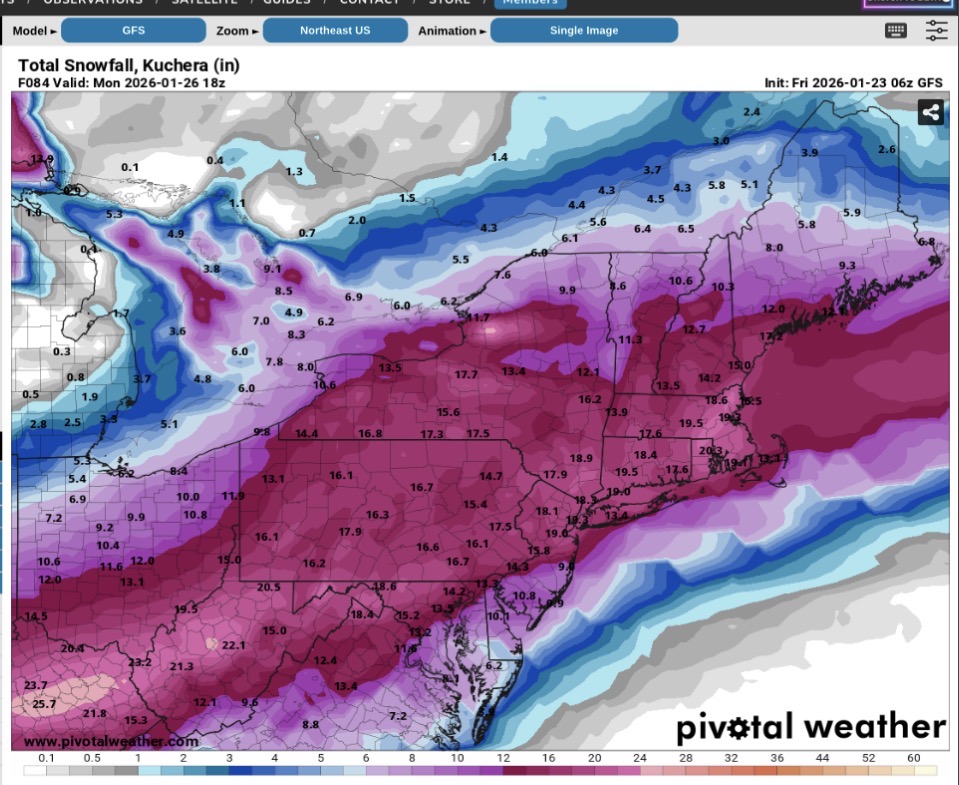
06z GFS