Cheeznado
-
Posts
2,155 -
Joined
-
Last visited
Content Type
Profiles
Blogs
Forums
American Weather
Media Demo
Store
Gallery
Everything posted by Cheeznado
-
I think think the RI has paused for at least a little while based on the last few fixes and the fact the eye has not gotten any clearer. This is a very small storm compared to Gilbert and Wilma which may be a factor for now.
-
984 now, HWRF does not have it that strong until 06Z Wed, Hmmmm.
-
Way too weak for any real eye to be present. Regarding landfall intensity I think that fairly rapid weakening right at the coast is likely due to cooler water and shear, it all depends on how strong it gets in the central Gulf. I noticed that the HWRF backed off of the intensity quite a bit with the 06Z run.
-
This GFS storm is not the area that NHC is watching right now- that system, if it develops, would probably stay down by the Yucatan or Bay of Campeche. The second one originates in the southern Caribbean.
-
A Central America hit in any case....
-
I find it rather interesting that despite the forecasts of a possible record # of storms it is awfully quiet right now (not counting that wimpy Josephine and the who-cares 96L off the Carolinas)- and none of the global models have much of anything through the end of the month- this is with the peak of the season approaching.
-
This forum should be renamed American Winter Weather- it is amazing how posts dry up almost completely once the threat of snow/ice is over. I love snow as much as the next person but am interested in all types of weather....
-
I think that is exactly what is happening.
-
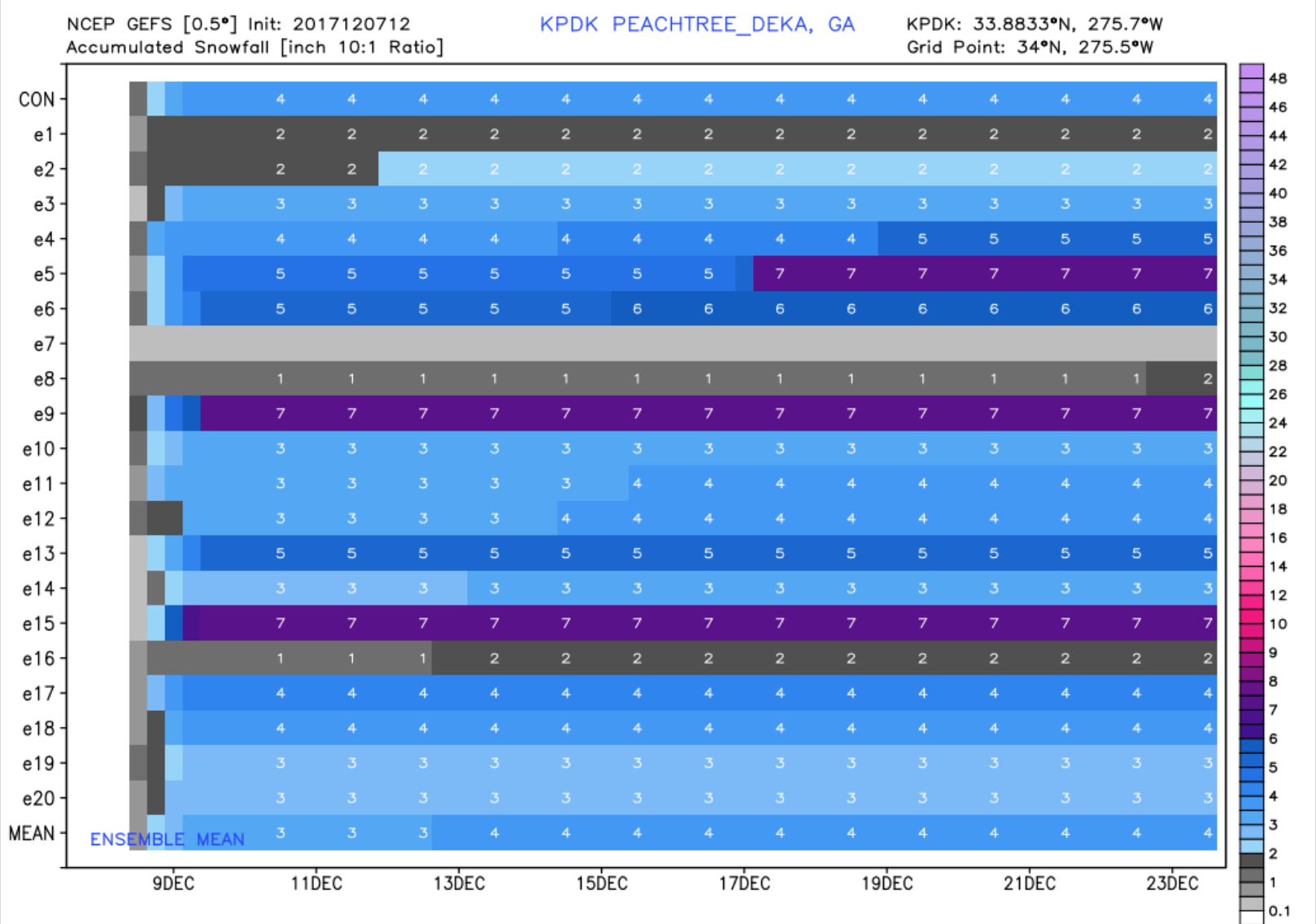
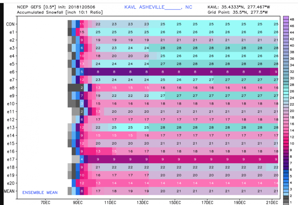
Pinch me, I will be headed to AVL tomorrow very early- if they get over 18" (and that seems to be a growing consensus) it will be the biggest snow storm ever there- also I have never personally seen that much snow in one storm.
-
Since here in ATL we will just get a nasty cold rain, I plan to travel up to the AVL area, the ensembles have been incredibly consistent with some very hefty totals, check out the 06Z ensembles- 14 members with 20" or more.
-
The December to Remember 7th-8th blue turd winter threat thread.
Cheeznado replied to lilj4425's topic in Southeastern States
This is a big shift for the GEFS- previous runs had half of the members a trace or nothing.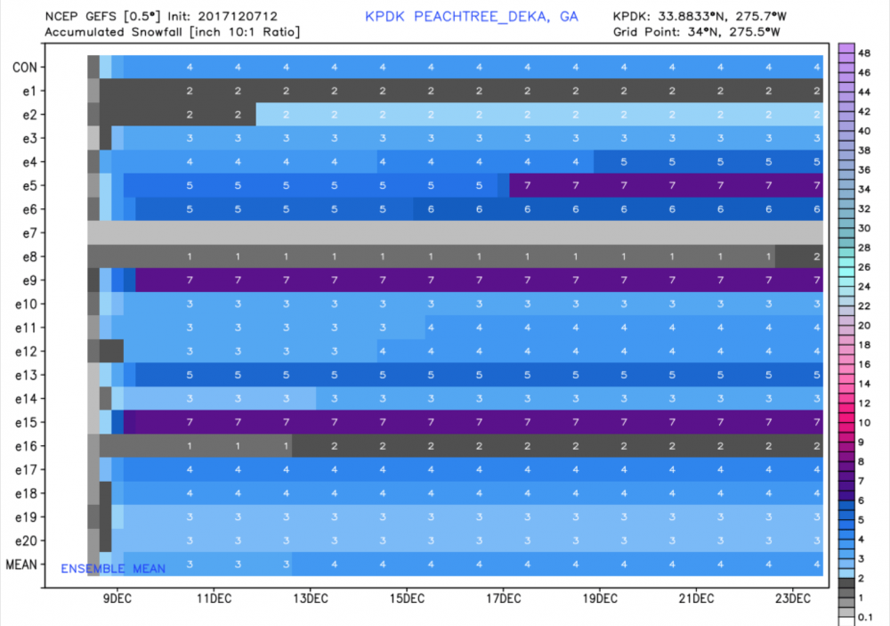
-
The December to Remember 7th-8th blue turd winter threat thread.
Cheeznado replied to lilj4425's topic in Southeastern States
This NAM trend is not surprising, just coming to the GEFS and EPS, a general 1-3" event here in GA, mainly from here SW. It was never going to stick much anyway, its early Dec for pity's sake, so no cliff diving here since I was suspicious of a big event all along. If I get a nice dusting to an inch or two on the grass it will be a bonus considering how much more of the winter is left. -
The December to Remember 7th-8th blue turd winter threat thread.
Cheeznado replied to lilj4425's topic in Southeastern States
Yep. 2-3" from Atlanta west. -
The December to Remember 7th-8th blue turd winter threat thread.
Cheeznado replied to lilj4425's topic in Southeastern States
EPS:
-
The December to Remember 7th-8th blue turd winter threat thread.
Cheeznado replied to lilj4425's topic in Southeastern States
Based on everything I see, from over half of the GEFS members with at least 1" here, some with 5" +, the Euro ensemble mean being over 1", the new very impressive NAM- I think we see snow almost for sure now, some accumulations possible on grass, cars etc area. Fingers crossed for the NAM to be right, but need to see more evidence, but the trends are favorable right now for it at least not being a total bust. -
Alaska/Western Canada obs and discussion
Cheeznado replied to patrick7032's topic in Central/Western States
All-time U.S. low temperature record threatened? The coldest temperature ever recorded in the U.S. was a -80°F (-62.2°C) reading from Prospect Creek, AK (about 180 miles north of Fairbanks) on January 23, 1971. A weather station just a few miles from Prospect Creek, the Jim River DOT site, appears to have recorded a low temperature between -78°F and -79°F Saturday morning (January 28, 2012), shortly before the weather station lost power. Keeping the power going at -70 is very tough, and it is not a surprise to see that the station lost power during this extraordinary cold snap. Power just returned this morning to the site, where the temperature was -66°F at 7 am AKST. Wunderground's weather historian Christopher C. Burt is corresponding with Alaska's state climatologist to get more information on whether the data during the power outage will be recoverable, and how reliable these near-record low temperature might be. http://www.wundergro...sters/show.html -
This should be pinned