

BlizzardNole
-
Posts
2,947 -
Joined
-
Last visited
Content Type
Profiles
Blogs
Forums
American Weather
Media Demo
Store
Gallery
Everything posted by BlizzardNole
-
Full overcast here now, 88/68. The cloudiness will help with the heavy watering I'll be doing later this afternoon
-
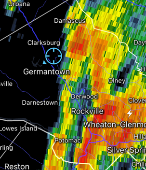
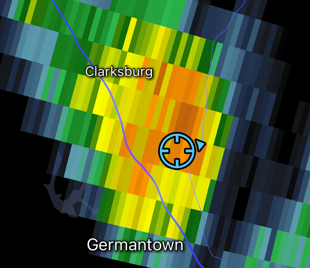
I know what you mean, NPZ. I'm in a rain shadow with high elevations from my W around to the NE. Thunderstorms regularly break up or split around as they descend towards here, then reform just east. I expect the same tomorrow and will be surprised to see more than a couple tenths of rain. My parched lawn HAD to cash in with that strat rain this past week and missed all the heavy stuff, some within a handful of miles. Got nickel and dimed to less than an inch total.
-
Ooof. Although further away, the KIAD radar looks OK for the Annp Balt area. I've been using that one (to watch other people's rain LOL)
-
I just can't believe so much rain is falling so close to the east. The other night it was just west. After today it's relying on thunderstorms so forget about it. We won't see a drop from those so we're done. Guess I'll be watering again this weekend
-
This heavy stuff is training NNE with the cutoff like 5 miles away. Just comical
-
Finally caught a couple small but intense showers, one earlier and this one just now. Each only lasted a few minutes but came down hard with some good sized drops. Measured 0.6 since yesterday evening. I don't know how much before that but guestimating 0.3 based on surrounding obs.
-
Wow that's impressive! Move the decimal a digit to the left and that's what I'd guess I've gotten. I hope I didn't jinx tonight's rain since I just bought a new rain gauge I used to just go off the iweather rainfall map which used to be really good. Man they broke that thing
-
Light drizzle and 61 Off topic but if you haven't seen video of the hailstorm that hit an outside concert in Colorado last night check it out here. Many were injured but it's a good thing the hail wasn't larger like they get out there sometimes
-
Starting to look like days of dreariness for less than a half inch of rain total. That's not gonna cut it, and shows what a joke those WPC precip forecasts are. LWX discussion looks familiar - afternoon batch of rain central VA to southern MD; tonight central VA foothills. After that it's afternoon thunderstorms which almost always miss here.
-
Breezy and 59 -- this is the solstice? Anyway some light rain off and on today and around 0.3-ish based on surrounding obs. Hoping for much more before we switch to the scattered T-storms in a few days as those typically miss here. Need stratiform rain
-
I won't believe any of these rain rumors until it happens. That crap last night was the epitome of this dust bowl nightmare - big heavy cluster of storms moving north right towards the Central MD Desert then veered NW just in time for storms to train just a few miles west for hours. I don't care how rainy the models look. Everything splits around or misses until it doesn't
-
Congrats to people just to the west. Nothing here and I'll call it now - it will not rain here at all next week. none
-
Good gawd huge blowup to my west moving N NW. Germandesert area cannot win for anything
-
Funny that they think we turn rainy right as LWX radar is out for 10 days starting Tuesday; I'll have to see it to believe it. I'll go with less that a quarter inch all the way thru the weekend Mostly cloudy and 87 here
-
Nice outflow boundary from those fading cells in central VA. Do more storms fire along that or too dry?
-
What a failure today was. I don't expect any rain at all next week either. This drought is getting bad
-
Philly area getting rocked wow
-
Right on cue. I'll take my 0.15 and sprinkles next week.
-
Thanks for posting that! The iweather rainfall map I used before no longer works either so this is great
-
It was frustrating seeing Gaithersburg just 10 miles away getting a heavy shower but that's the way it goes here. Cool start today at 53
-
Ran the sprinklers for the garden beds; grass will have to just go dormant. I've accepted that this will be an extreme drought summer
-
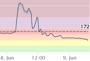
Much nicer air this morning and maybe we get to enjoy a beautiful Friday. Here's the closest AQI measurement to me -- look at that spike early Thursday morning reaching 409 at 5 am
-
What a glorious week it would have been without that smoke. I'll take a Bermuda high and southerly winds please
-
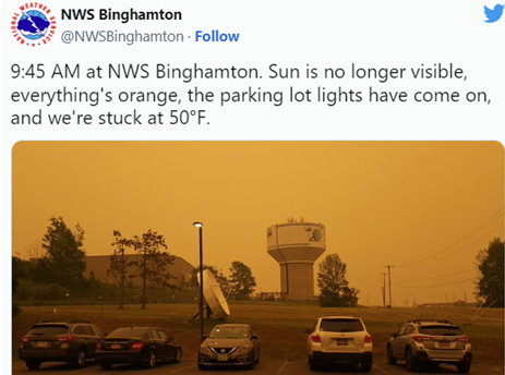
This blurb from NWS Binghamton from a while ago is just crazy
-
Mid 60s to low 70s at noon on June 5 with full sun. Amazing!


