

BlizzardNole
-
Posts
2,920 -
Joined
-
Last visited
Content Type
Profiles
Blogs
Forums
American Weather
Media Demo
Store
Gallery
Everything posted by BlizzardNole
-
Sunny and 77/70 with no wind. Just walked the dog and whew it feels hot already -- what's 87 gonna feel like? Sun-Tues sure looking tasty!
-
Models calling for coastal low next Thu/Fri with rain and highs only low/mid 50s -- yuck! The first part of the week looks great though
-
0.25 overnight for a total of 2.85, and 5.15 for the month. Seeing some breaks in the clouds to the south and west -- yes please!
-
2.6 just NE of Germantown. Awesome!
-
Steady rain and 2.4 so far, putting me at 4.7 for the month. What a stunning turnaround after a dry winter with just light snows, and less than an inch of rainfall each for March and April. Before this month I had less than 6 inches total precip for the year
-
I was just noticing that -- do not like the look of heavy, training t-storms aiming right towards the Cumberland area
-
1.0 so far with quite a slug moving up I-95 between Fredericksburg and Richmond. And take a look at the heavy, stationary band banked up against the Alleghenies from NW of Harrisonburg to Garrett County!
-
This is how a Gulf low is supposed to be! Wake up to several tenths of precip already accumulated and coming down moderately, with great looking radar to the south. If only I got that in January! This will be great for the garden I just planted
-
Congrats Stephens City? Do we believe that?
-
0.4 total and 2.3 for the month. Huge turnaround from the extremely dry March and April with less than an inch each
-
Did you snatch my rain shield generator?
-
Overnight batch helped me to 0.8 for yesterday and 1.9 since Saturday. Damascus, just 6 miles north, has a CoCoRaHS report of 3.2. I'd like to see the totals for southern FredCo!
-
0.40 for today. Not what I was hoping for but I'll take it. It is just like Saturday with much heavier totals just west of me
-
Yeah finally a nice hit by some good rains and some rolling thunder too! Much needed for my parched garden
-
I mean, radar looks great but I need to see heavy rain before I believe it
-
Having a rough day here with cells training NW-ward missing me both left and right. Can't seem to catch one
-
Those are some good rainers moving SE-to-NW into southern FredCo. I got under the edge of one a little while ago in Darnestown and it was coming down! FredCo looking like a winner in this event so far
-
1 inch on the nose so far which is great! Big gradient with places just a few miles west well over 2" while just to my SE like Rockville less than 0.5. Hoping we all get some good rounds -- tomorrow afternoon sounds promising
-
This is why I wish so much for a screen in porch some day!
-
You aren't kidding! There are gonna be some impressive totals from that area - they've been getting trained for hours. I'm just now getting close to the edge of that train hoping to get under it
-
All that large hail talk trust me you do not want it! It sounds like a hundred guys pounding on your roof with sledgehammers, combined with window after window shattering. You go out after it's over in a daze looking at your dented car and broken windows everywhere. Seen it twice and hopefully never again! Got a third little shot of rain and greedily hoping for more later on
-
A welcome 0.3 so far from getting scraped by the southern edge of two cells so far. Hoping for a flush hit at some point. Had one super-close lightning strike, had to have been within a couple hundred feet
-
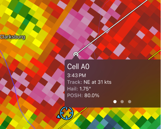
I just missed the heart of that nasty MontCo cell, and I am GLAD. I got approx. 0.75" hail for a few minutes so I am thinking Clarksburg got it bad. I do not like hail one bit after experiencing baseball size hail twice (Kettering, MD 1978; Orlando 1992)
-
Quick light shower that blew up to my east, which happens a lot. That's why I'm really hoping for stratiform rain because t-storms rarely work for my spot
-
These snippets from LWX make me hopeful for central MD! Some guidance indicates increased convergence between I-81 and I-95 amid increasing PWATs Saturday night, which could lead to localized higher rainfall totals. Sunday afternoon and evening. In addition, there is some potential for training of heavier showers and thunderstorms particularly east of the Blue Ridge towards I-95 where it looks like the best overlap of low-level convergence and higher PWATs will exist


