Juliancolton
-
Posts
8,585 -
Joined
Content Type
Profiles
Blogs
Forums
American Weather
Media Demo
Store
Gallery
Everything posted by Juliancolton
-

2/13 Light/Moderate Snowfall Nowcasting & Observations
Juliancolton replied to Northof78's topic in New York City Metro
Nice to wake up to 2.8" on the board. Waiting for my Stratus to melt, but it's not hard to see this is very high-ratio stuff. Fgn (and HRRR) ftw -
Just some small patches of ice in shaded areas here. Mud is starting to get epic.
-
Wind has started ripping here the last hour. What a waste of 48-50F.
-
Yeah, that's true. I was wearing my microspikes like a total dork while working out in the yard yesterday afternoon. Still, it was necessary to keep from careening down the hill. The sun did little to soften the patches of smooth ice in the lawn.
-
It was quite slick here this morning, and still is, but rapidly approaching 40F now so shouldn't be an issue much longer. I'm not surprised there were school delays.
-
Zip codes didn't exist until the 1960s. Come on!
-
Wait until you guys hear about the Netherlands.
-
Aren't you the guy who's always carrying on about geoengineering?
-
https://en.wikipedia.org/wiki/Marble_Hill,_Manhattan
-
All of the continents are just big islands
-
Well, I wasn't on-board until I saw the 96-hour KMA Asian domain, lock it up.
-
The moisture was really shallow... snizzle vs drizzle probably came down to tiny variations in ice nuclei/sfc temp/elevation
-
More drizzle this afternoon. Welcome to the next 14 weeks!
-
I used my tractor to scrape the driveway on Saturday morning, then threw some salt down in the critical spots. It made things worse in the short-term but allowed everything to melt out quickly when the sun hit it on Sunday. Completely clean now.
-
That's awesome. How can anyone not love this season?
-
I hope that clown-range storm on the globals disappears for like a week before roaring back to life on D3/4. I've had my fill of tracking for the year, just need it to actually snow now.
-
A few medium-sized white pine branches have fallen, but otherwise no major issues. Those are pretty awful trees... I feel like I've just spent 20 years cleaning up after them. Had a bumper crop of limbs in December 2008.
-
Sounds about right. Doubt I'll be able to get a car back down to the road in anything resembling a controlled manner. I'll have to sit home smoking cigars and drinking bourbon all weekend.
-
I'm not really sure about what to do with my driveway. Another round of freezing rain this afternoon has totally locked in the 1/2" or so of sleet.
-
It's still getting colder here. 21/20
-
Even without looking at radar or LSRs/mPING, you can easily see the southern limit of significant ice by its societal effects. Pretty cool how closely these are aligned.
-
Only a light glaze at home before the sleet started, thankfully. Mean radial was 2mm, so well under 1/10th of an inch. It seems like the far northern reaches of Dutchess did "better" on the ZR front.
-
Very early. Just dropped below freezing near Millbrook... the cold air is pushing south quickly.
-
Down to 33 and still pouring, with 1.25" on the day so far. This is probably not going to be fun.
-
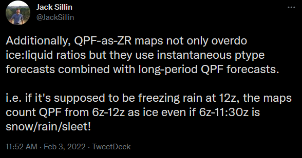
Here's something I only just learned that makes those maps even more worthless, at least for the GFS. Bonkers.