

Juliancolton
-
Posts
8,595 -
Joined
Content Type
Profiles
Blogs
Forums
American Weather
Media Demo
Store
Gallery
Everything posted by Juliancolton
-
How's the creek holding up?
-
Thought we'd be drying up by now, but still sheet drizzle. The worst winter in memory seamlessly parlaying into the worst spring in memory. Tipper says 3.00" storm total so we'll see what the Stratus truth is when I feel like wading through the yard.
-
Taking a beating here. Torrential rains, rather potent gusts with power surges and small branches coming down, and much more thunder and lightning than I expected.
-
I wouldn't worry... the lawn guys will be talking about abnormally dry conditions by mid-May.
-
Looks like a real gully washer tomorrow night. Aren't we lucky.
-
What are the coordinates? I can't find it edit: nvm, I see it. That's fun, hopefully it stays put until the lock
-
My pond overflowed big time on Thursday night with those downpours. I had to go down yesterday with my tractor and scrape all the riprap off the road and back into the ditch. The county would have gotten to it in about a week... maybe. If they felt like it.
-
Storms were nothing to write home about. A few close-ish lightning bolts, though.
-
That will vaporize before it gets here with the ridge cresting over the area. In all likelihood, we're dry until late tomorrow night. (edit: ninja'd by Rob)
-
17 for a low here, currently 25. At least it's finally sunny enough to put all my seedlings back in their cold frame for the day. They were starting to get leggy under grow lights inside.
-
This is extremely disappointing.
-
It's been just off to my northeast all morning. Some spots north of the village have picked up an inch or two.
-
No hail, grauple, squalls or any other convective appeal up here. Just on and off steady rain throughout the day.
-
The plows did more damage to my yard than all of the winter storms combined, as is tradition.
-
How did you manage to take a Civil War tintype photo in 2006?
-
How long until the Kucheras start flying?
-
6 out of the last 8 years here had accumulating snow after today's date, 2021 and 2017 being the odd ones out. With troughiness on the EPS right through the end of the month, I'd say it's pretty much a lock that we will see additional measurable snow.
-
The mosquitoes were terrible today.
-
Peepers are out in force tonight, love to hear it. Tomorrow is probably the warmest day until April I would think... hopefully everyone can get out and enjoy it.
-
At least we're safe from the Russians for a while.
-
Confirmed, I'm angry about losing boots, cars, and the occasional dog to the ravenous pits of mud in my yard
-
Mud
-
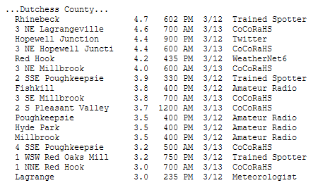
Definitely a perennial snow hole. Over the years I've commented on how my little hollow here is great for cold but poor for snow. That said, with 1" from the evening activity bringing me up to 2.8", my total wasn't a world away from other reports in central and eastern Dutchess.
-
Nice. It seems like areas west of the Taconic got into higher rates for a bit longer.
-
2.1" is my "generous" measurement, more like 1.8" on the board. Terrible.


