

CaryWx
-
Posts
2,667 -
Joined
-
Last visited
Content Type
Profiles
Blogs
Forums
American Weather
Media Demo
Store
Gallery
Posts posted by CaryWx
-
-
-
Granted the NAM has been fairly consistent for what--4 runs in a row now?
Still, this just makes me want to see the 12z LR model runs. The diversity in solutions will most assuredly need to start consolidating soon. We have all the RAOBs ingested now right?
-
1 minute ago, TARHEELPROGRAMMER88 said:
NAM is now hundreds of miles east with the low
you sure?
-
4 minutes ago, BullCityWx said:
That was a foot for sure for almost all the triangle if it ran to the end of the event
You think the Triangle had another 4hrs or so?
-
Just now, eyewall said:
I am liking this trend like everyone else. Let's see the GFS climb aboard next!
I'd say it's more or less aboard but not showing this intensity track quite yet.
-
2 minutes ago, StantonParkHoya said:
We used to make fun of people who rode the 84 hr NAM vs the Euro
I'm not so wound up in NAM snow totals or where/when it changes over this far out, but the NAM hopefully can't be too far off on synoptics of the system track, etc.
-
 2
2
-
-
1 minute ago, Blue_Ridge_Escarpment said:
The trends are still going. I don’t see a whole lot stopping it from coming even further west.
Precip. blossoming west for sure. LP track seems about the same. Maybe a little tick south/southwest
-
I'd say it's still snowing in east/northeast NC at 84hrs so this wasn't over. Maybe a several more hours left.
-
hang on...
-
Just now, StoneColdWeatherAustin said:
With the current GFS look, the precipitation outputs look meek. I would expect much more liquid if it plays out like that.
Yeah, not going to worry about precip amts at this range just yet. A wind up LP off the coast can bring the noise
-
1
-
-
2 minutes ago, BornAgain13 said:
Much improved on the 18z GFS.... alot of folks get in on accumulating snow this run... not far from the NAM... should be better ensembles...
If the ensembles tell us it should be where the 18z NAM is or even further sw we could be on to something of scale
-
1
-
-
12 minutes ago, Brick Tamland said:

If that was headed up the coast the Triangle was going to get a smoke show in the following 6hrs
-
2
-
 1
1
-
-
Well now. Not a bad spot. About 75miles south of cape lookout and 100 or so off Myrtle?
-
2
-
-
46 minutes ago, PantherJustin said:
Aren’t we all to the point now where the 84hr NAM will slap us in the mouth with some unrealistic Scenario ? Atleast we have that to look forward to….

That model also showed 200 mile shifts in a matter of 2 runs last week I believe.
-
1
-
 1
1
-
-
1 minute ago, Brick Tamland said:
EPS not bad for RDU. 2/3 have at least 2 inches for RDU.
I think RDU gets a little backside snow as it intensifies and pulls north/northeast but that's about it.
-
2 minutes ago, PackGrad05 said:
Euro ensembles will be a better gauge.
I agree. Do not understand the more dampened out moisture field with the overall set up.
-
1
-
-
actually a little further sw?
-
I can't tell if the 84hr synoptics on the NAM are favorable for Carolina snows or not. Can you elaborate a bit?
-
5 minutes ago, BornAgain13 said:
Kind of a weird thought , but how can a Meteorologist say to not post a crazy snow map 6 days out but it's okay to post a temperature map or a map that shows no snow 6 days out... isn't that an oxymoron? 1 is just as likely not to happen than the other... maybe I'm wrong...
probabilistic is the operative word I'm guessing. Some maps are safer bets than others.
-
2
-
-
Not a bad place to be at this range.
-
4
-
-
3 minutes ago, Sandstorm94 said:
GFS called this past week 2 weeks ago
Sent from my SM-S115DL using Tapatalk
Wasn't this storm on the gfs just a couple days ago
-
Not sure I have the emotional meteorology mettle to bounce up and down for a third week here
-
6
-
1
-
5
-
-
3 minutes ago, PantherJustin said:
NP! I could see us getting 1-2” up here if we’re lucky we will see man!

-
10 hours ago, lilj4425 said:
I brought the mojo.


-
1
-
Potential 1/28-1/30 2022 winter storm
in Southeastern States
Posted
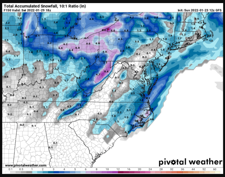
GFS lining up with last euro run it seems on that band thru western piedmont. eastern piedmont a little drier?