

CaryWx
-
Posts
2,667 -
Joined
-
Last visited
Content Type
Profiles
Blogs
Forums
American Weather
Media Demo
Store
Gallery
Posts posted by CaryWx
-
-
Just now, burrel2 said:
eyore is a fictional character in the Winnie-the-Pooh books by A. A. Milne. He is generally characterized as a pessimistic, gloomy, depressed, anhedonic, old grey stuffed donkey
Yes I know I was just renaming eyewall eyeore. Sorry it was confusing.
-
 2
2
-
-
9 minutes ago, burrel2 said:
You're going to Eeyore your way in to a big snowstorm and I can already see it coming. lol
burrel, that was just funny. eyeore?
-
1
-
-
10 minutes ago, Blue_Ridge_Escarpment said:
That’s a good sign. Much colder run.
Does that include sleet. Always forget about what UK and CMC reflect in their frozen precip maps
-
 1
1
-
-
27 minutes ago, burrel2 said:
Here's the sounding for Raleigh Sunday at 1pm as precip is pivoting just to your south on the 00z Euro. Does that look like too warm/ice to rain scenario?
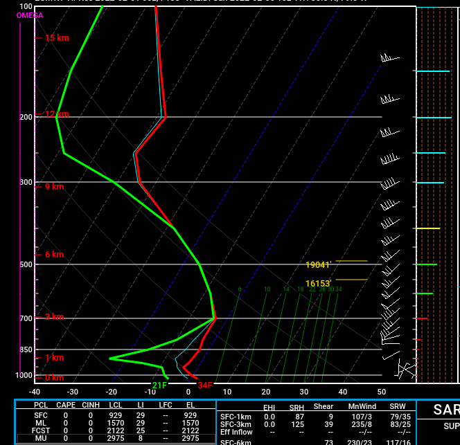
Thanks Burrel. Looks like a pretty good snow sign at 850 (at that specific time) unless I have something wrong. Ground truth would be what I call dripping snow though unless 2m temps do indeed get driven down below 0c while 850s stay below 0c.
-
I'm skeptical this event produces much of anything for the Triangle beyond a little zr early on. As pointed out by others the cold is simply not there enough early on and retreating rapidly as storm develops. Congrats to the mountain (maybe foothills) folks. Think you score decently here.
-
Have to see if 0z gfs still has the system. Maybe colder like the euro?
-
15 minutes ago, TARHEELPROGRAMMER88 said:
You know the answer here. Nada.
Better than SC I would imagine unless it is a slider
-
5 minutes ago, burrel2 said:
My god the 18z gfs ensemble members are absolutely loaded with hits around day 8/9.
Can you post?
-
6 minutes ago, eyewall said:
Neither the Euro or GFS shows anything promising in the foreseeable future. It appears the SE ridge is going to strengthen and kill us. The clock is ticking so hopefully that trends weaker as we go on.
-
unless I'm mistaken that's some pretty solid continental cold
-
2
-
-
35 minutes ago, chris624wx said:
Yep, add the 00z CMC into the west camp! GFS on an island right now.
and maybe UK now
-
-
1 minute ago, wake4est said:
Excited to see the GFS probably rip the rug out from under us..
Yeah, Fv3 was more like 18z gfs and euro. This 0z suite will be telling maybe. Need to see it swing more to NAM look
-
1
-
-
Just now, BornAgain13 said:
Geez, the 0z NAM knows how to get us excited...
Almost all inside it's wheelhouse of 48hrs. Vast majority of this activity anyway. This is not some 72-84hr window we're looking at
-
1
-
-
If the NAM is wrong I don't wanna be right!
-
1
-
-
1000mb LP southeast of Frying Pan shoals at 51hrs!
-
Yowzers!
-
1
-
-
Per 18z gfs precip output model Wake county will be shopping at 'the gap'.
-
4
-
-
11 minutes ago, TARHEELPROGRAMMER88 said:
NAM going to go boom at 18z? Sure. GFS at 18z? Sure. Why not. This is the crazy world of models.
not so sure this time
-
1
-
-
13 minutes ago, PantherJustin said:
So I'm still struggling to understand here. Is this indicative of an earlier phase the euro and gfs have yet to pick up on?
-
Just now, Brick Tamland said:
So we've gone from a eastern NC hit to a western NC hit. Glad to see we're narrowing this one down.
Well euro and gfs are aligning more anyway on the 12z runs
-
Just now, olafminesaw said:
Eh, getting into the range where that's no longer true. The higher resolution of the OP serves our purposes better
Yeah was thinking that myself
-
1 minute ago, HKY_WX said:
Euro continues to trend the ridge out west stronger. This is what's allowing the PJ to dig/dive a bit further southwest and capture some of the southern energy. Interesting trend to watch.
Not sure I follow. Is this more towards the NAM or a solution further east and a later phase.
-
Getting some really strung out snow totals on these models that have concentrations in various and somewhat odd configurations across NC. Have to believe the final fruition would be more smoothly aligned. Wherever that will be.

Mid to Long Range Discussion ~ 2022
in Southeastern States
Posted
As burrel alluded to though does a blend of gfs and euro produce more snow or do the synoptics (too amped= warm w/ice but less amped not enough precip?) on this particular set-up just not going to work that way.