

CaryWx
-
Posts
2,667 -
Joined
-
Last visited
Content Type
Profiles
Blogs
Forums
American Weather
Media Demo
Store
Gallery
Posts posted by CaryWx
-
-
18 minutes ago, wncsnow said:
The trough orientation doesn't look ideal for a miller A, then the MJO goes into its warm phases later this month.
It's in it's warm phases now isn't it?
-
Brick's gonna want some NIL $$
-
 1
1
-
 3
3
-
-
18z gfs says look at my fantasy
-
2 minutes ago, SnowDawg said:
Genuinely jealous of people who didn't fall into the trap of this hobby. Weather models are basically crack from what I can tell. Everytime I try to tell myself to just stop looking, I find myself waking up at 2am just to sneak a peak at the Euro lol
While I'm in the camp of solidly waiting a couple of weeks before looking at this winter (from a pattern whole) more critically I suggest holding off on the 2am looks until we are actually tracking a storm.
")
-
Patience folks. Well know in about 10 days or so where things are headed probably. Can kicking won't mean much after that.
-
1
-
1
-
-
1 hour ago, BooneWX said:
What's a moderate value? +1?
-
-
2 hours ago, TARHEELPROGRAMMER88 said:
Blanking is the new norm in most of NC. NC has become like SC and GA used to be for snow. Those places are becoming like N FL.
and Va becoming what NC used to be?
-
2
-
-
28 minutes ago, Tyler Penland said:
Checking Spaceweather after the big solar flare today and they had posted about the SSW. Hopefully this will lead to good things for us soon.
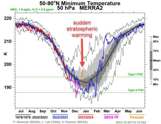
This again?
-
Yeah, but they have snow on their island.
-
4
-
-
Looks pretty good after ~12th-15th timeframe
-
1
-
-
1 hour ago, olafminesaw said:
Oof. Torches at the surface verbatim, with insufficient cold air, despite the perfect track and being timed well with the cold air. Probably would be snow in this scenario, but might not really even accumulate. Of course, this is still pretty far out, but we keep seeing this system too warm at the surface. Hopefully we see that change towards mid-month.
.thumb.png.6cc7c822b51eaa70dbc41ed21e2ebd85.png)
Man! That is super torchy for 2m temps considering how cold it is even at 900. Would think BL temps to be 33-34F range at worse with that look. How is that thin surface warm layer squeezing in under there anyway? Of course none of this is fully correct yet anyway
-
1
-
-
Porch light prognosis reveals mixed precip now as well
-
1
-
-
11/14/16 F below norms? We don't get that without some vortex activity.
20F below norms? That's kind of off the scale
-
1
-
-
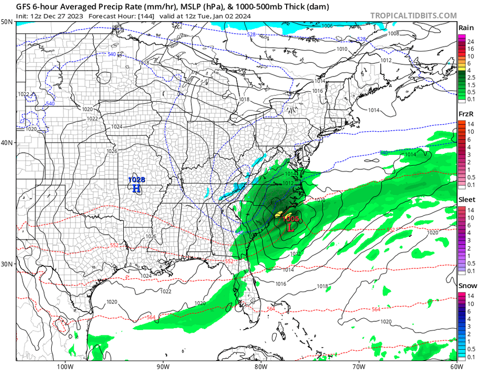
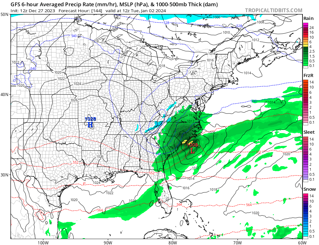
Wow at the pivot developing between Raleigh and Greensboro! If that were snow....
-
2
-
1
-
-
12 minutes ago, GaWx said:
Model consensus 12/25 fwiw threat of rain much of SE and mainly warmer than normal with SW upper flow. I say fwiw because it still being 8 days out means lots of uncertainty/model inaccuracy.
Yes, right now Christmas looks rainy
-
Looks to be a little faster than originally projected. At least from my radar Obs
-
14 minutes ago, eyewall said:
Alright you have me there lol. For some reason I had 3 in my head.
Well I have to be totally transparent. Just a weakness of mine.
")
We are both correct depending on how you read this. Just the NWS. What do they know.
-
2
-
-
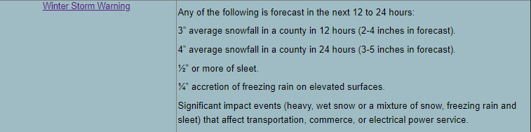
4 hours ago, eyewall said:
3 inches is warning I thought in central NC.
-
4
-
-
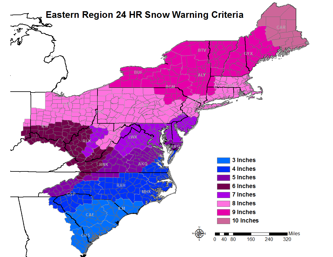
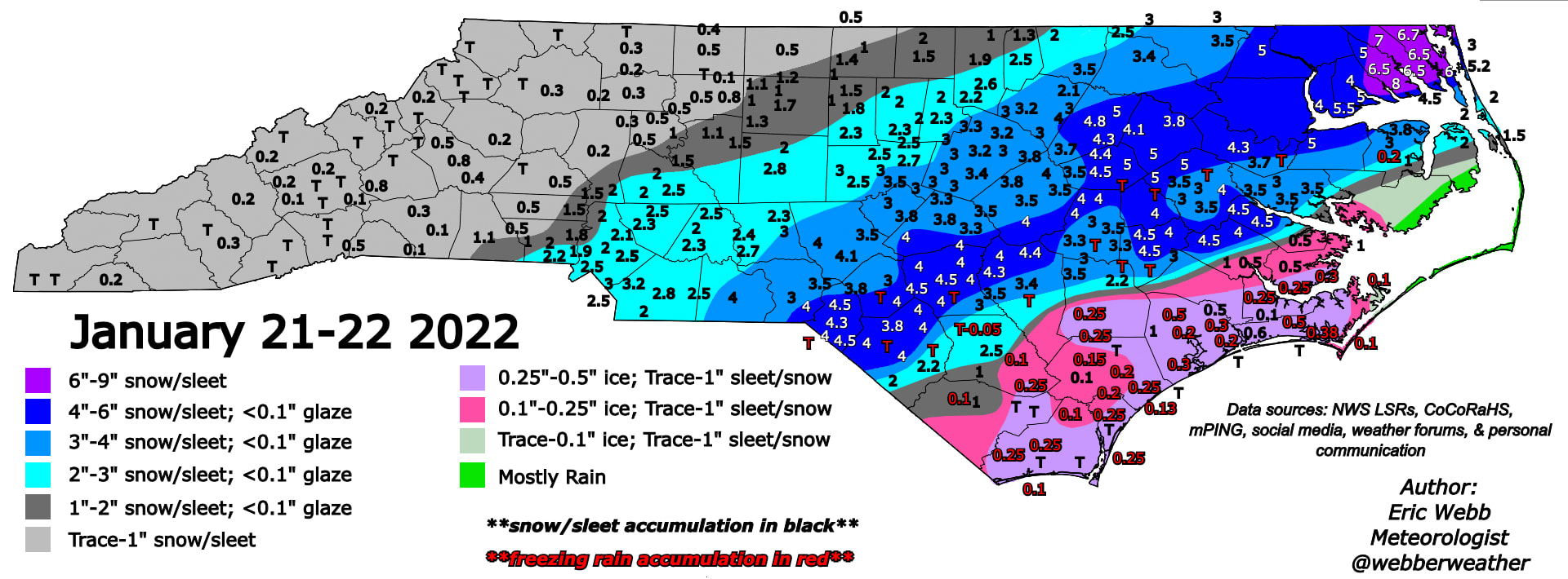
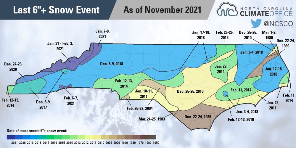
Found this but believe it was mostly sleet.
-
1 minute ago, buckeyefan1 said:
That map is for 6+” not approximately 4
Yes, but I've not seen even 4 since early Dec 2018.
-
45 minutes ago, eyewall said:
There should have been measurable there once in the winter of 2021-2022 and 2020-2021.
Decent measurable? Like warning criteria (~4")? Don't think we've sniffed that
-
 3
3
-
-
Don't think I've seen a decent measurable snow in Cary since early Dec '18. That's five yrs now.
-
1
-
-
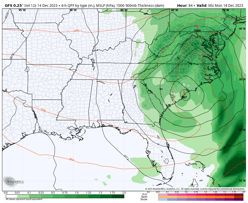
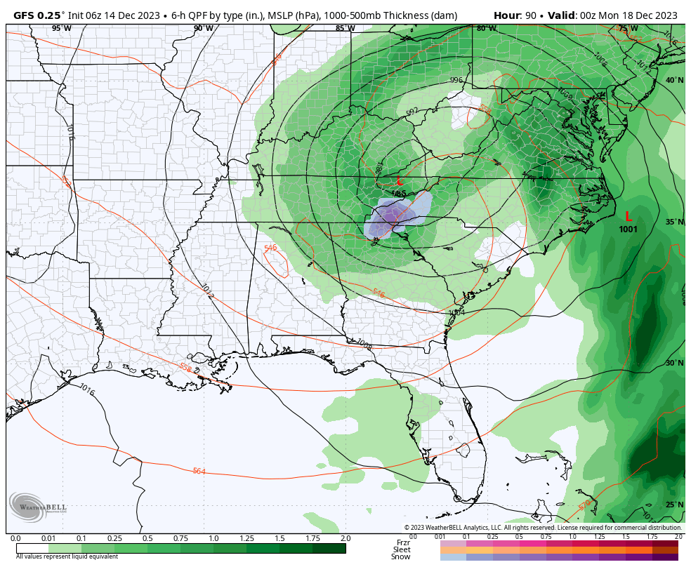
49 minutes ago, eyewall said:
yeah for sure. The 12z GFS is significantly farther east with the surface low but the main ULL is definitely much farther north.
12z:
6z: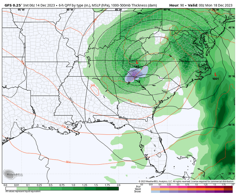
Kind of a wonky shift to me. Still not resolved imho
.png.4eacd0b4576240240b4becbeebd843b9.png)

Mid to Long Range Discussion ~ 2024
in Southeastern States
Posted
How long did those nino's hold though? Isn't ours weakening fast? Read we are headed quickly towards a nina in Spring.