

CaryWx
-
Posts
2,667 -
Joined
-
Last visited
Content Type
Profiles
Blogs
Forums
American Weather
Media Demo
Store
Gallery
Posts posted by CaryWx
-
-
18z GEFS looks better
-
 1
1
-
 1
1
-
-
2 minutes ago, BooneWX said:
While we’re putting out requests, mark me down for it to be a 1040
")
a 1040 might knock you off the mountain.

-
 1
1
-
-
18 minutes ago, BooneWX said:
Come to think of it, the last 3 model cycles have introduced very drastic changes to our cold air source from the north. If we’re trending away from the 50/50 low as a source, we really need that high to anchor.
You're referring the one in the OV showing up on the ensembles correct? I need it just a hair east and anchored.
")
-
1
-
-
49 minutes ago, Leesville Wx Hawk said:
Agreed.
.Me as well. I hate counting on the "undermodeled" but is has and does happen with CAD
-
20 minutes ago, WinstonSalemArlington said:
What does NC need for this storm to work out? Example: 1) A low track from TX/OK border thru the SE. 2) A Low anchored in the NE, aka 50/50 low, that helps drive in our cold air given we don’t have a banana High or large HP cold source.
Thanks for the deep dive.
-
6 minutes ago, BornAgain13 said:
Not a forecast! But fun to look at. This is the KMA for the possible 4th-5th storm

Sent from my SM-N981U using Tapatalk

-
2
-
5
-
1
-
-
Yeah at range this is good stuff! Be a bit before it's resolved more precisely
-
1
-
-
Just now, PackGrad05 said:
EPS really likes the Feb 5-9 time period
Is this like some kind of "blue horseshoe" comment from the Wall Street movie
-
14 minutes ago, NorthHillsWx said:
The fact this forum is debating geographic regions instead of analyzing digital blue today is telling…
We're analyzing long range patterns in prime climo while I'm sitting at 65 degrees. How about you?
-
3
-
2
-
-
Weather regions should not be drawn by political or metropolitan boundaries rather geographically and atmospherically. However geo political are more readily accepted and easier to view.
-
7 minutes ago, Met1985 said:
For yalls area I do understand your frustration. It is way harder to get snow down yalls way than up here in the mountains. But I still wouldn't completely take your area out of the probability to see some snow this year.
The "frustration" is a miss on even our annual average much less a drought coming up on 2yrs in a row. And now looking at +300hr models for even a simple favorable pattern. You can understand this, right?
-
3
-
-
Larry, Where's the mjo going to be you think during this time? 8-1-2? I know that's in the noise range currently
-
10 minutes ago, eyewall said:
No Gods No Masters!
Well, how many wait staff do you really need in this restaurant?

-
3
-
-
On 1/13/2024 at 12:02 PM, SnowGoose69 said:
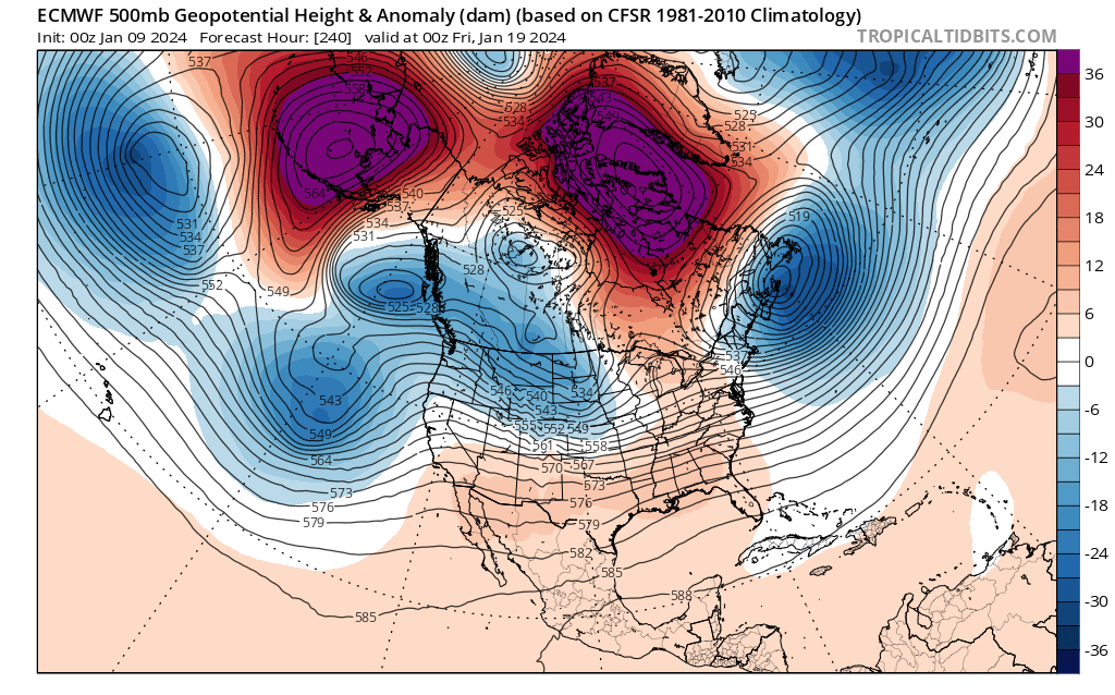
Models went through a bit of a pullback yesterday delaying the reset but overnight ensembles sort of went back to things looking fairly good again by 1/27-1/28 after 1/21-1/26 are fairly warm...the problem is the pattern is largely just a cold dry/warm wet look outside of New England...the NAO is positive and the western ridge is too far west on the GEFS/GEPS...the EPS is better but the pattern still sort of screams that any big storm would cut N of the MA or SE US. Regardless, there won't be trees blooming in February this year across the SE US for the first time a good 7-8 years probably
Ya still think so?
-
1
-
-
36 minutes ago, Divine said:
The idea you can accurately project the weather form a month from now is laughable. Things can change very quick. You should not trust weather 7-10 days out, much less a period a month from now.
Agreed but the larger feature indices are all we have to go on. Granted many have low score verification, especially in the noise range
-
1 hour ago, NorthHillsWx said:
Kinda feels like we’ve got one shot left. We burn that first week in February we are definitely running out of time
We have two imo. Early first couple (few?) days in Feb and then a period between the 14th and 21st but that's airing it out
-
1 hour ago, Upstate Tiger said:
Looking at the long range out 14 days to first week of Feb., the cold in Canada looks better today and looked even better overnight. NAO looks to stay positive but so does PNA. MJO looks to maybe get through 6 and some plots have it going into 7. Still feel like we get our chance in February.
https://www.cpc.ncep.noaa.gov/products/precip/CWlink/pna/nao_index_mrf.shtml
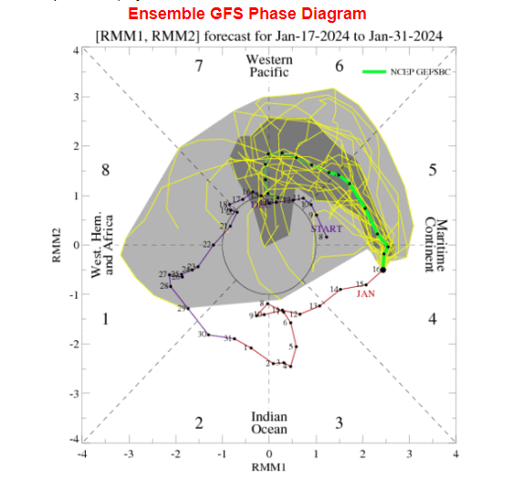
Me as well. For the mjo I don't look too far beyond 7 days for the mean. Even there it has tightened ever so slightly in the last few days closer to the center circle in it's rotation
That phase 7 curl back to 6 at day-14? Yeah, not sure we are going to see that.
-
It miller B's just a little too far north and late
-
We still have time but now looking like February for sure which gets close to if not at winter 4th qtr.
-
1
-
-
19 minutes ago, SnowGoose69 said:
Its moving too fast. We have had some discussions about this on twitter/forums recent days that historically waves that move fast in mod or greater ENSOs have reduced impact. Also, the GEFS badly overdid the strength, all winter so far EPS has been too weak/GEFS too strong but this time the EPS almost looks like its forecast 10 days back for late Jan may win...both have also been too slow moving the waves
The mjo will be aligned when we get out to 23rd or so with what should actually be happening in our region. From the 26th on though I'm curious how fast it moves to near the CoD or over to 7/8 space.
-
Just now, BooneWX said:
Another good run for the pieces of energy, it just didn’t translate to the surface map like we would hope
ensembles await
-
1
-
-
squashed ain't bad
-
-
2 minutes ago, SnowDawg said:
Looks temporary. Blocks still in place and another shot on its way SE with PNA starting to push north.

With that block and 50/50 in place, if the PNA can pump enough for a wave to dig I'd say that's a threatening look for around the 20th.
Will the cold make it over the apps though

Mid to Long Range Discussion ~ 2024
in Southeastern States
Posted
lol even Bermuda colder