

CaryWx
-
Posts
2,667 -
Joined
-
Last visited
Content Type
Profiles
Blogs
Forums
American Weather
Media Demo
Store
Gallery
Posts posted by CaryWx
-
-
-
4 hours ago, NorthHillsWx said:
Early next week’s Miller A with a perfect storm track and absolutely no cold air is going to sting. That being said, if that track continues this year eventually we will score
Well it's not even astro winter yet and we are only at 35N so my expectations aren't there yet.
I do get your larger point though
No cold in sight, anywhere, is worse than our usual 'delayed' winter at this point.
-
2 hours ago, nchighcountrywx said:
This is a shot across the bow. Major change in the outlook
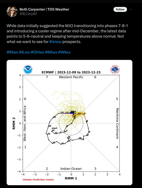
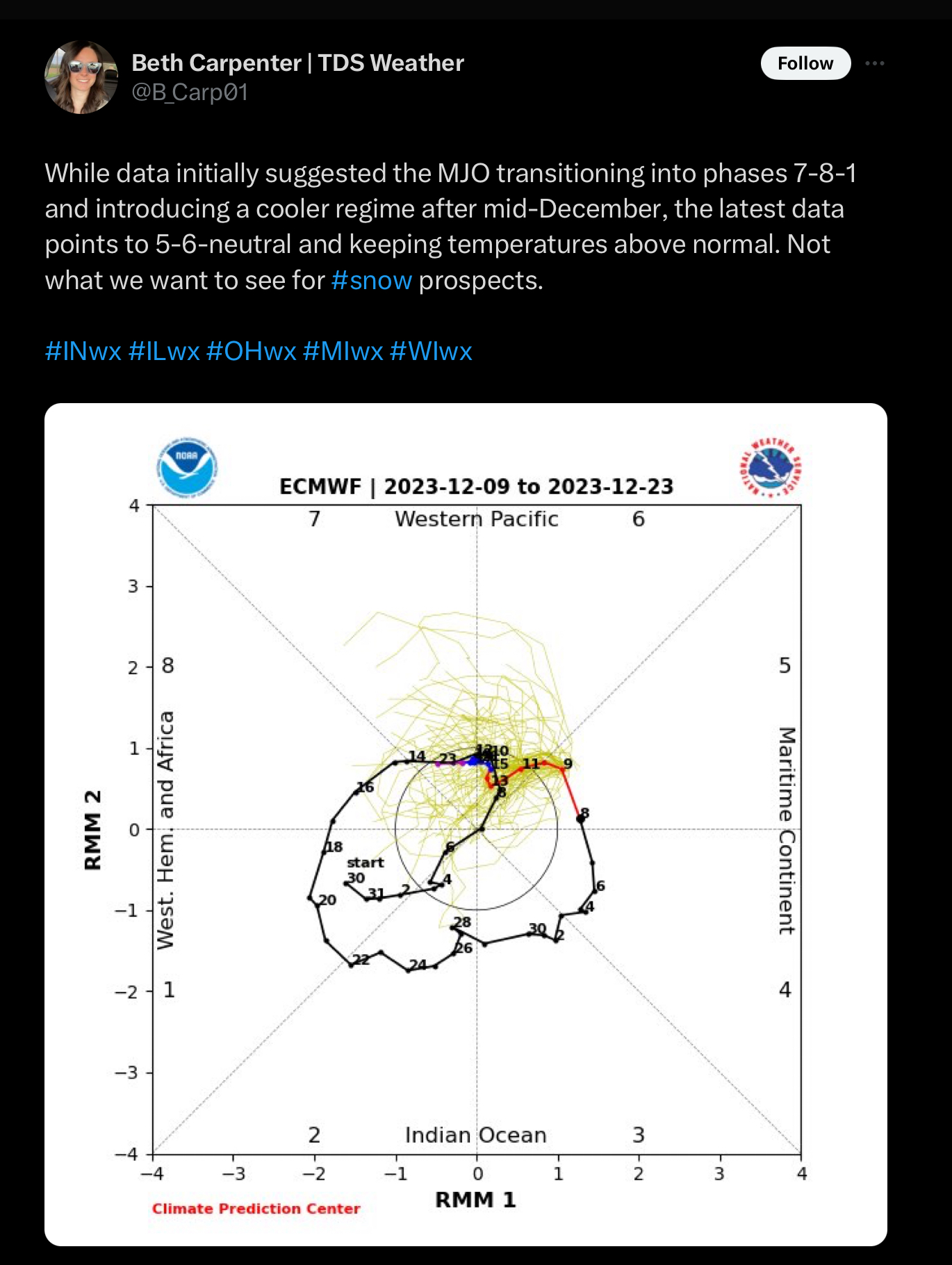
Maybe I'm reading this incorrectly but I see a projection out to the 23rd and certainly while in the CoD is still in phase 7. How is this a 5-6 regime forecast?
-
37 minutes ago, buckeyefan1 said:
What part of from Christmas to the 2nd week of January is the 17th to Christmas? Sigh
-
 3
3
-
-
No worries. The coming winter STJ will solve our problems
-
 2
2
-
4
-
-
Also from NWS...
Winter Forecasting Tools: Here’s What’s New at NOAA this Year
- This winter, NOAA will implement a series of upgrades and improvements. In November, the experimental Probabilistic Winter Storm Severity Index (PWSSI) will become operational. The product will enhance communication with external partners, media, and the general public by graphically depicting the likelihood of potential societal impacts due to expected winter hazards over a 7-day period. This is complemented by a version of the Winter Storm Severity Index (WSSI) based on the official National Weather Service forecast of the most likely conditions over the next three days.
- NOAA’s Weather Prediction and Climate Prediction Centers will continue to use Winter Key Messages, which highlight the agency’s most essential information for upcoming winter weather, including extreme cold and heavy snow potential. These can be found under “Top Stories” on the Weather Prediction Center’s and Climate Prediction Center’s websites.
- This winter, NOAA will complete its implementation of Impact-Based Warning Tags for Snow Squall Warnings. Snow Squall Warnings are warnings issued for short duration intense bursts of snow and wind leading to whiteout visibility and possible flash freezes on roads. To distinguish high-impact snow squalls, the National Weather Service will issue impact-based Snow Squall Warnings using the “Significant” tag for events that pose a substantial threat to safe travel. Wireless Emergency Alerts, which are emergency messages sent by authorized government alerting authorities through wireless carriers, will be limited to only high-impact Snow Squall Warnings with the Snow Squall Impact Tag of “Significant.”
-
2
-
-
27 minutes ago, WinstonSalemArlington said:
Scandinavian blocking
That plus the Vancoverish ridge and western Alaskan trough
-
3
-
-
Skeptical right now that midwest blast makes it into the southeast but we'll feel some effects east of the apps.
-
1
-
-
36 minutes ago, eyewall said:
It is going to be an EF-2 or 3 for sure. NWS sure waiting a long time to pull the tor when a CC drop was present for multiple frames.
I think we need to give NWS a little room here. A bit premature
-
24 minutes ago, marsman said:
Awful smoke today, I could smell it - needed some eye drops this morning. High of 96.7 at 3:15pm. No precip since 7/14.
96.7? Don't think it hit that in my neck of the woods
-
On 7/15/2023 at 9:00 PM, Wow said:
If this is it, please let me know. Cuz if this is snow you better let me know.
-
1
-
-
On 7/14/2023 at 3:02 PM, Upstate Tiger said:
While we deal with this ongoing hot pattern...latest ENSO predictions increase chance for moderate to strong El Nino. 97/98 and 15/16 are analogs. Neither were stellar years in the SE FWIW but it only takes one!
The most recent IRI plume indicates El Niño will persist through the Northern Hemisphere winter 2023-24 [Fig. 6]. Forecasters favor continued growth of El Niño through the fall, peaking this winter with moderate-to-strong intensity (81% chance of November-January Niño-3.4 ≥ 1.0°C). An event that becomes "historically strong" (seasonally averaged Niño-3.4 ≥ 2.0°C), rivaling the winters of 1997-98 or 2015-16, has an approximately 1 in 5 chance. In summary, there is a greater than 90% chance that El Niño will continue through the Northern Hemisphere winter [Fig. 7].
https://www.cpc.ncep.noaa.gov/products/analysis_monitoring/enso_advisory/ensodisc.shtml
Ryan Hall is not really calling for a strong nino this year but it's still early.
-
What's a good Nino signal for next year for the southeast? I think no more than moderate. Maybe 1.5-1.75??
Asking the experts.
Thanks
-
If that ULL at 500 on the 18z gfs could just get some intensity going we'd have good storm
-
Looks like a mtns and foothills storm to me unless something changes
-
44 minutes ago, eyewall said:

I actually think you're being a little generously east here and I'm not usually in your grouse boat
")
-
1
-
-
From NWS RAH longer forecast...
Models have trended significantly slower with the trough, with a closed low even
developing and tracking to our south, helping a surface low deepen
off the NC coast. This would result in a wetter solution for our
region than previously thought, so bumped up POPs to chance during
this period. Northerly flow around the low and a weak high over New
England may result in temperatures cold enough for some snow or
mixed rain/snow. The 12z GFS is especially aggressive with depicting
this potential, but even the 12z ECMWF trended more in this
direction. Model soundings appear it would be more of question of
rain vs snow instead of ice. Almost half of 12z GEFS at least have
some measurable snow in some part of central NC, with less CMC
ensembles and only a small percentage of ECMWF ensembles showing it.
Uncertainty this far out is quite high, and would like to see more
consistency in the models. Even still, the latest model trends at
least justified introducing a chance of rain or snow in most places
Saturday night. Because of the uncertainty in the overall setup this
weekend, confidence in temperatures this weekend is low, but for now
forecast highs are slightly below normal.
-
1
-
-
3 hours ago, bess said:
Shoot down a chinese weather balloon and weird things happen…
.Released a weather virus? Darn clever those Chinese!
-
1
-
-
I usually give it until Feb 20th on the calendar. If there is nothing showing on the 10day once we get to 2/20 I tend to check out because now were hoping for the 2nd week of March or beyond for the LR proggs and well...that's just betting against climo and you're staying in the casino too long.
-
1
-
-
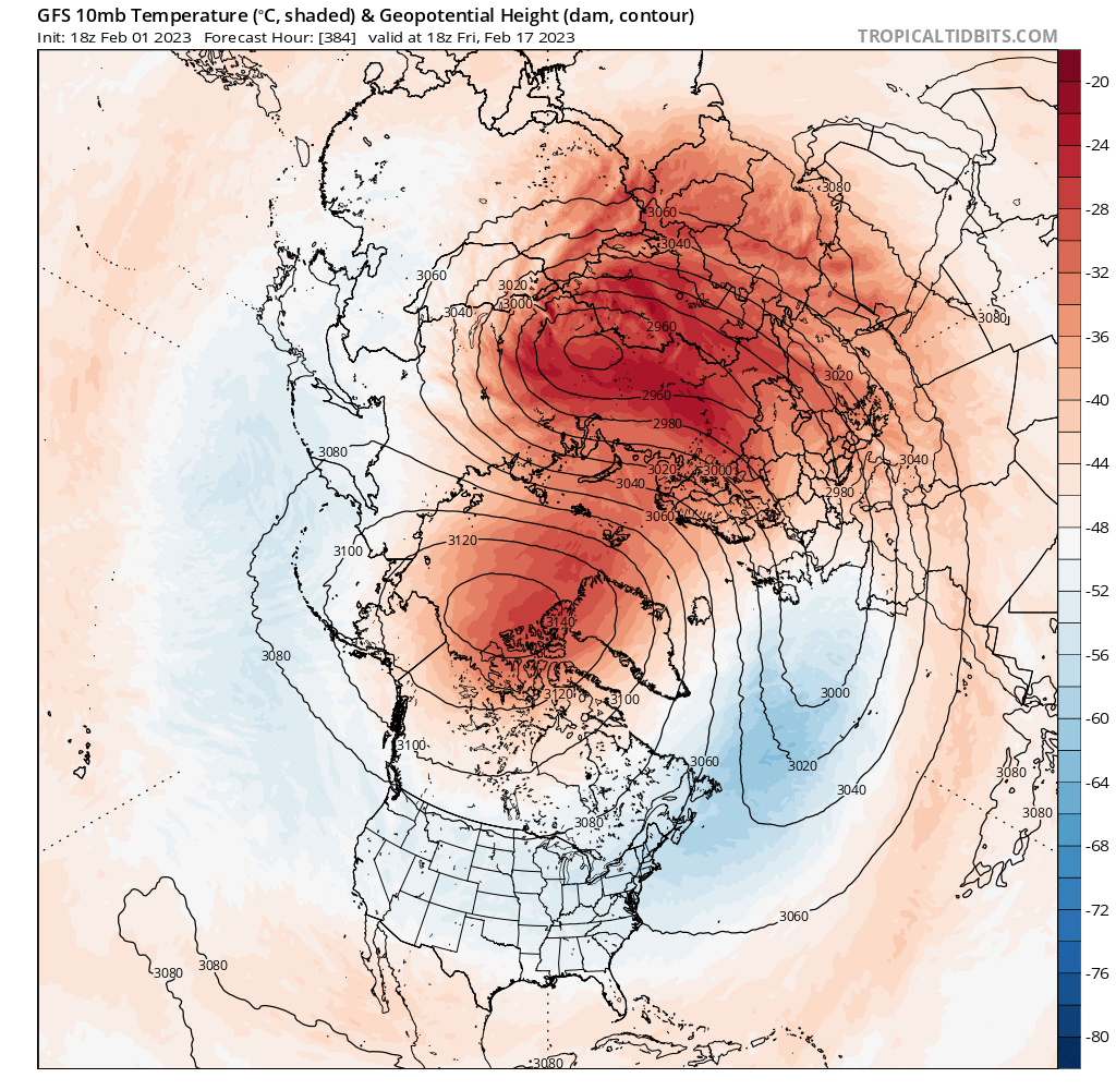
13 minutes ago, GaWx said:
If this isn't a major SSW on the 18Z GFS at 10 mb, then I don't know what one is: high in the Arctic has replaced the SPV with E winds at 60N all around it, the Arctic is much warmer than normal, and the SPV has plunged WAY south to 50N with it stretched/splitting. I know this is just the GFS late in the run (very unreliable), but the trends the last few days have been headed toward a midmonth disruption/warming. If this were an isolated GFS run showing this with no prior support of strat changes at midmonth, I wouldn't have posted thi:

Isn't this pretty late to make any difference winterwx wise. Even for NC outside the mountains? Downstream effects would be after Feb 25th right?
-
9 minutes ago, SnowDawg said:
Lol, our luck somehow the forecasted rapid onset El Niño is going to turn into La Niña coming back for round four by the time we get past summer.
4 'ninas in a row is highly rare. When was the last one?
-
25 minutes ago, Upstate Tiger said:
I swore this winter if I caught myself relying on SSW, I’d throw in the towel but here I am!
GW is that the reason we’re seeing those crazy HP readings in Canada on the GFS starting mid-month? I’m seeing highest I’ve seen all winter.
That SSW will be too late I'm afraid
-
20 minutes ago, NorthHillsWx said:
18z is an absolute clinic on how to flex the SER
Well, the OP run anyway


![[Fig. 6]](https://www.cpc.ncep.noaa.gov/products/analysis_monitoring/enso_advisory/figure06.gif)
![[Fig. 7]](https://www.cpc.ncep.noaa.gov/products/analysis_monitoring/enso_advisory/figure07.gif)
Mid to Long Range Discussion ~ 2023
in Southeastern States
Posted
oy