

CaryWx
-
Posts
2,667 -
Joined
-
Last visited
Content Type
Profiles
Blogs
Forums
American Weather
Media Demo
Store
Gallery
Posts posted by CaryWx
-
-
-
SSW not looking to be major I'm hearing.
-
19 minutes ago, purduewx80 said:
Peep the CPC MJO discussion for why the RMM plots are biased too weak in the extended. This discussion updates Monday afternoons. If that holds true, guidance showing a -PNA in early to mid-Feb will hold true.
As for next week, here's a cluster analysis on the 8-to-10-day period. Think of the 4 top solutions as ensembles that are grouped together based on their similarity. No cluster is necessarily more likely than the other, but you can see the percentages of each ensemble that supports that mean. C - Canadian, G - GEFS, E - EPS. The full ensemble mean and anomalies are on the very bottom, so it's a good way to look at all the ensembles blended together. There are important differences in the Pacific, but you'll note that even with the blocking on some guidance over AK (cluster 3), all the cold air dumps into the West, Plains and Great Lakes during this period. If the Hudson Bay vortex ends up being two separate areas as is hinted at, that could open the door for more cold air damming to sneak in east of the mountains.
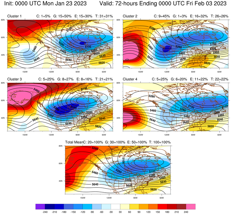
So if I'm reading this correctly cluster-1 with the highest percentage supports this statement below? Cluster-4 has it too but not so much for the southeast
"If the Hudson Bay vortex ends up being two separate areas as is hinted at, that could open the door for more cold air damming to sneak in east of the mountains."
Not that it is any more likely as 31% isn't a fantastic chance to start with but decent among 4 cluster possibilities.
-
1 hour ago, GaWx said:
Tomorrow will be when the SSW starts in the Arctic. This has been the timing on the GEFS since I started following it closely a week ago. It still looks about as strong as it ever has on the GEFS. The N Pole is still progged to warm at 10 mb a whopping 40C/72F+ during just a 5 day period ending 1/28! And then it warms even more into early Feb.
What's still in doubt is whether it gets classified as a "major" SSW or a "minor" SSW. "Major" requires a wind shift from W to E at the 10 mb level at 60N+. Regardless, it will be a strong SSW (rapid, strong warming). The eventual effects on the SE remain to be seen. However, the history of actual "major" SSW events suggests that the bulk of potential significant, persistent cooling in the SE US related to this would most likely not occur til at least 10-15 days after the SSW (per the maps I posted two days ago) when a -AO dominates. These same maps as well as stats I looked at suggest that the 1-2 week period right after the SSW would typically average near to AN prior to the cold with a +AO prevailing.
Looking at the MJO forecasts, the GEFS is still largely on its own with a forecast of a moderate phase 4 within two weeks. The others turn back into the COD, which wouldn't be a warm signal.
We'll see how this evolves, especially since it may not reach the "major" SSW classification. But would that matter much with this strong of a warming? We'll see.
GaWx,
Do you know when we would expect to see the wind shift/reversal if it does actually occur?
As always, great synthesis on the upcoming forecast
-
 1
1
-
-
2 hours ago, NorthHillsWx said:
IMO overnight runs confirmed the window is from the 26th-2nd. After that we likely warm.
What about the coming SSWE?
-
8 minutes ago, eyewall said:
Nevermind you are skipping to the system after that LOL
The yield is not much better for mby though.
-
 1
1
-
-
23 minutes ago, eyewall said:
The Euro is an inland runner. This can easily go cutter like the rest.
Not really an inland runner
-
20 minutes ago, NorthHillsWx said:
12z GEFS was in a word: BAD
Reverts back to a western trough. Pacific reigns supreme through the run. Hopefully it remains on an island
hug that model now
-
58 minutes ago, BooneWX said:
I was just making a generalization about the pattern and likelihood of a Nina year producing Feb cold. We need those same ensembles to start showing a change in the medium range because they’ve been showing a long range “change” for about 2 and a half weeks.
Agree here. They do seem to can-kick on many occasions but precise timing at the long range is not a banner component for them
-
 1
1
-
-
47 minutes ago, BooneWX said:
The latter would probably be more likely in a Nina year. We desperately need things to flip this month or it might be time to start getting the lawn mower serviced.
Please look at the composite ensembles for the other major LR models. Criminy folks
-
2
-
-
1 hour ago, eyewall said:
We are going to be fast approaching "sun angle and soil temp" season by the time there is even a remote chance it feels like. Being completely blanked on the season is on the table.
That almost sounds like a troll post. And believe me, I'm a dreaded sun angle guy. However I'm also astute enough to know sun-angle has little bearing on winter storm occurrence opportunities. At least during the season. It is more an issue with staying power for snow cover and the like. By the way in our red neck of the woods it's not really relevant until about 2/15 or so.
-
2
-
-
I caution folks on the northwest trend. This is a transient state. Wobbles and full on shifts can and do happen.
-
4
-
 1
1
-
-
40 minutes ago, WinstonSalemArlington said:
That pic is bigfoot blurry
-
 4
4
-
-
Give it time. Headed for a week of warm and yuck but guessing we'll be looking at future opportunities by the end of next week
-
2
-
1
-
-
1 hour ago, GaWx said:
Today's 12Z model consensus, if anything, is a bit further from SE significant wintry precip 12/26-7 vs yesterday's runs. With it now being one day closer, the already pretty low chances have dropped further. I would have expected something more showing up by the 12Z runs today, like a closer to the SE coast surface low formation, if the trend were heading toward a threat. Yesterday was sort of headed toward that but today has backed off.
Almost towel time unless the passage of this front changes model proggs
-
1
-
-
14 minutes ago, buckeyefan1 said:
While we wait on the next run, here is 12z from the gfs and dr no. Can you spot the difference


Yes. Yes I can. Hint: Look at the states of Montana and Idaho vs the Dakotas.
-
2
-
1
-
-
Santa storms? You bet
-
1
-
-
2 minutes ago, JoshM said:
And don't forget the after Christmas special LOL

Boxing Day storm
-
1
-
-
gfs 0z OP putting out some ridiculous stuff...but the fun kind
-
1
-
-
I think this big drink is coming with a chaser
-
1
-
-
Those are from 12z
-
2
-
-
Big cold!
-
18 minutes ago, eyewall said:
I hope everyone enjoyed the happy hour model runs yesterday because this morning there seems to be a nasty hangover.
ICON coming in
-
Don't lean on the OP runs this far out. Good or bad
-
4
-
Mid to Long Range Discussion ~ 2023
in Southeastern States
Posted
When was the last time we had 4 Ninas in a row?