

CaryWx
-
Posts
2,667 -
Joined
-
Last visited
Content Type
Profiles
Blogs
Forums
American Weather
Media Demo
Store
Gallery
Posts posted by CaryWx
-
-
2 minutes ago, PackGrad05 said:
I'd be shocked to see more than 3" anywhere in Wake. Trust me, I'm pulling for it, but based on climatology and situations like this in the past, I agree with RAH's statement about the dry air this far back and the extent of the western precip shield.
I'm going 1-3" across Wake, with most areas 1-2". Still a great snow!
I hear you but typically your lead off comments 9x out of 10 would be attributing low totals to ip/zr. Now we contend with air that is too dry and cold aloft. We indeed live on a cutting edge weather gradient
-
 1
1
-
-
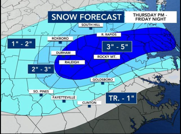
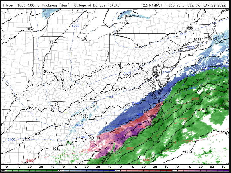
From RAH as of 5am
A wave of surface low pressure will then move offshore along the
stalled Arctic front later Friday into Friday night, with a mid-
level shortwave trough moving across NC. This will give the first
significant accumulating snow of the season to many parts of central
NC. Snow will spread from SE to NW from the late afternoon into the
overnight hours, heaviest and most widespread from about 00z to 06z
and exiting to the east by about 09z (possibly ending as freezing
drizzle) as dry air quickly moves in. Essentially all models,
including the GFS and ECMWF as well as short-term high-res models
like the NAM, RAP, and HRRR, have trended farther west with the low
and its associated precipitation shield during the last 24 hours.
Thus raised POPs to likely to categorical across most of the region
except the far NW, and increased forecast snowfall totals slightly.
Generally expect 3-4 inches east of I-95, 2-3 inches from the US-1
corridor to I-95, and a dusting to 2 inches NW of there. It should
be stressed that there is still some uncertainty on these totals, in
particular on how far west the snow shield will make it, as it will
be fighting dry air in the NW. The GFS continues to insist on a
stronger jet streak and associated upper divergence, and thus brings
the snow much farther west than other models do. Forecast amounts
may have to be raised a bit further if models continue their
westward trend, though the 06z NAM and GFS look very similar to
their 00z runs. Thus for now continue the Winter Storm Warnings and
Winter Weather Advisories as is, and will reassess the need to
change anything after the 12z guidance comes in. One thing we are
confident about is that the column will be sufficiently cold for
snow nearly everywhere. The one exception is the far SE (mainly
southern Sampson County) where models show still having enough warm
air aloft to stay sleet and freezing rain for much of the event.
Thus a tenth to a quarter inch of freezing rain is still forecast in
southern parts of Sampson county. Lows will be in the mid-teens to
lower-20s on Friday night with continued north winds around the
deepening low off the coast. This will bring wind chills down to the
single digits to lower-teens.
-
6 minutes ago, PantherJustin said:
so I was excited about trends when I went to bed…. Then even this AM I thought they didn’t really budge …. But I’ve lived by a rule my entire weather Weenie life it doesn’t matter what models say if you’re not under a Winter Weather Product …. You’re missing something and it’s not gonna do anything lol but I thought I’d wake up to atleast a WWA
Yeah after the overnight models thought Wake country would be upgraded to a WSW but looks like RAH left their advisories as is.
-
-
It's a good run for the euro.
-
2
-
-
Just now, TARHEELPROGRAMMER88 said:
Totals for RDU? Map?
not yet
-
 1
1
-
-
-
euro telling other models--I got game too
-
 2
2
-
-
How good is the RGEM at this range?
-
2
-
-
Can someone drop in Fishel's magic 2:30 tweet if it's out?
-
meathead meteorology?
-
This storm has moved southwest. More into NC. I noticed the moisture on earlier models building more into SC so wondered if that is what was happening.
-
2
-
-
Just now, Leesville Wx Hawk said:
RGEM looks good. A trend?
Well, rock solid and one of the most steady run-to-run. If true will be pretty good.
-
1 minute ago, jlewis1111 said:
Is this for today too or just fri sat storm?
Total thru Sun morning
-
2
-
-
1 minute ago, NorthHillsWx said:
Oh I’m in no way saying that. Yesterday there was the question of whether we’d get ANYTHING other than the fropa. Now it’s looking more likely to have a decent snow. I’ll be so happy with 2 inches of snow falling into 25 degrees I can’t even tell y’all
As soon as I spoke the RGEM brings glory back to the Triangle.
")
-
1
-
-
18 minutes ago, NorthHillsWx said:
The dam has burst and the NW trend has hit
I would be careful here. Don't think we're going back o 3-6 in the Triangle...but we might
-
-
8 minutes ago, HKY_WX said:
Def favorable trends in most models over the last cycle or 2.
Is it slowing down or speeding up in your opinion or about same pace? I do see the larger precip fields and denser moisture
-
1 minute ago, NorthHillsWx said:
NAM was a GREAT run for I-95 and was almost back to the Triangle! That’s a massive improvement across the board
Looks more amplified to me but LP further east than 06z?
-
Just watched WRAL 11pm weather. They have completely abandoned any snowfall amount predictions now
Forget this chart we know it's old.
What's odd is they did not even hazard to go with an updated one in the broadcast but rather punted to tomorrow morning. Sort of disappointed they backed off the courage to do that.
-
1
-
-
1 minute ago, Avdave said:
she did mention the triangle area.
"We will still see impactful winter weather and accumulations on Thursday night (including the Triangle) and parts of our viewing area will still see a major winter storm Friday"
"and" differentiator so it's ambiguous. (including the Triangle) could be referencing the former and not the latter.
But it's petty for this thread.
-
14 minutes ago, Avdave said:
Major winter storm in the Triangle? What is she looking at? Maybe for Elizabeth City.
Not Triangle the viewing area. I suspect points around Rocky Mount are going to get a bigger hit. I appreciated her info on why they didn't give in to the short range models right now. As always the northwest trend seems to happen in these parts.
-
15 minutes ago, ILMRoss said:
Not going to lie if the 00zssssssssss windshield wipe and come back with a vengeance tonight the broadcast mets hedging for big totals are going to look really flippin smart
I will sing their praises in the snow
-
2
-
-
13 minutes ago, PantherJustin said:
Everyone in Raleigh needs to chill…. These models are way off. We all know by Tomm night it will be right back how it was…. It will change 9x more every run of (model suites) it wouldn’t surprise me if all of them lose it then start creeping back by 06z runs Tomm …. This happens every storm we have a day of crap runs then it ends up just fine or some result not even shown like last weeks HRR …. Stop trusting Computers they have ZERO clue …. Ppl need to go back to looking at Fronts ect on paper and stop trusting computers
Please tell me you're being a bit facetious here
-
1
-
5
-

January 20-22 “bring the mojo” winter storm threat
in Southeastern States
Posted
You're now practically in the sweet spot 21hrs out Brick.