

CaryWx
-
Posts
2,667 -
Joined
-
Last visited
Content Type
Profiles
Blogs
Forums
American Weather
Media Demo
Store
Gallery
Posts posted by CaryWx
-
-
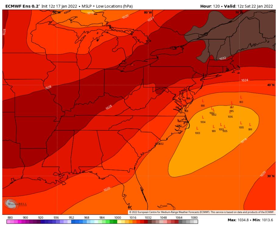
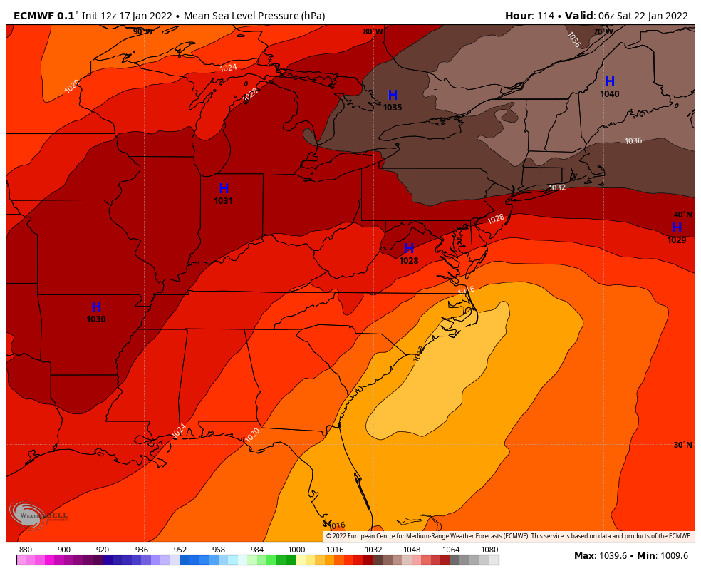
Most models agreeing now and focusing the center on NE NC/SE VA just not on intensity?
-
CMC suppression really making the 12z euro a thing of anticipation now. Would think better alignment would be in the cards by now instead of the ways this phase/no-phase is getting handled still.
-
 1
1
-
-
1 minute ago, HKY_WX said:
Yeah didn't see too much on this run.
gfs does seem to be handling this whole thing in a clunky fashion run-to-run more so than how the European is managing it.
-
Just now, HKY_WX said:
The main diff b/n the euro and gfs is the EURO phases the northern stream impulse with the stj impulse over Texas below. If you see the GFS start trend towards a solution where that s/w is being phased into the northern trough then you know it's caving towards the EURO. Will be interesting to watch.

I didn't really see that this time on 12z gfs. The 12z euro going to be interesting to see how it continues to handle.
-
Where does the miller-B transfer look to set up? From SC coast to off Hatteras?
-
Remember it's the NAM at 84. Overall set up more reliable than p-type specifics/locations and amounts right?
-
 2
2
-
-
1 minute ago, msuwx said:
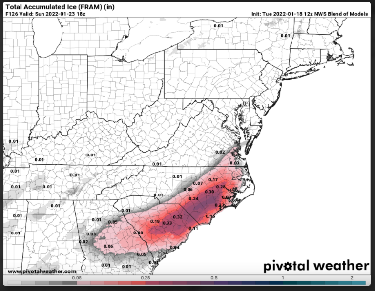
That is a stronger ice signal on the NBM than I ever remember seeing leading up to our last storm.
I'll defer to you here certainly Matt but are you seeing severe ice in the Triangle?
-
Model blends. Less ice in he Triangle metro area?
-
14 minutes ago, nwohweather said:
It will not be huge because we're still days out, not really even in Winter Storm Watch range. From the looks of it though, seems like one hell of an ice storm for the Carolinas
Read back on Sunday where ROAB gets ingested more today
-
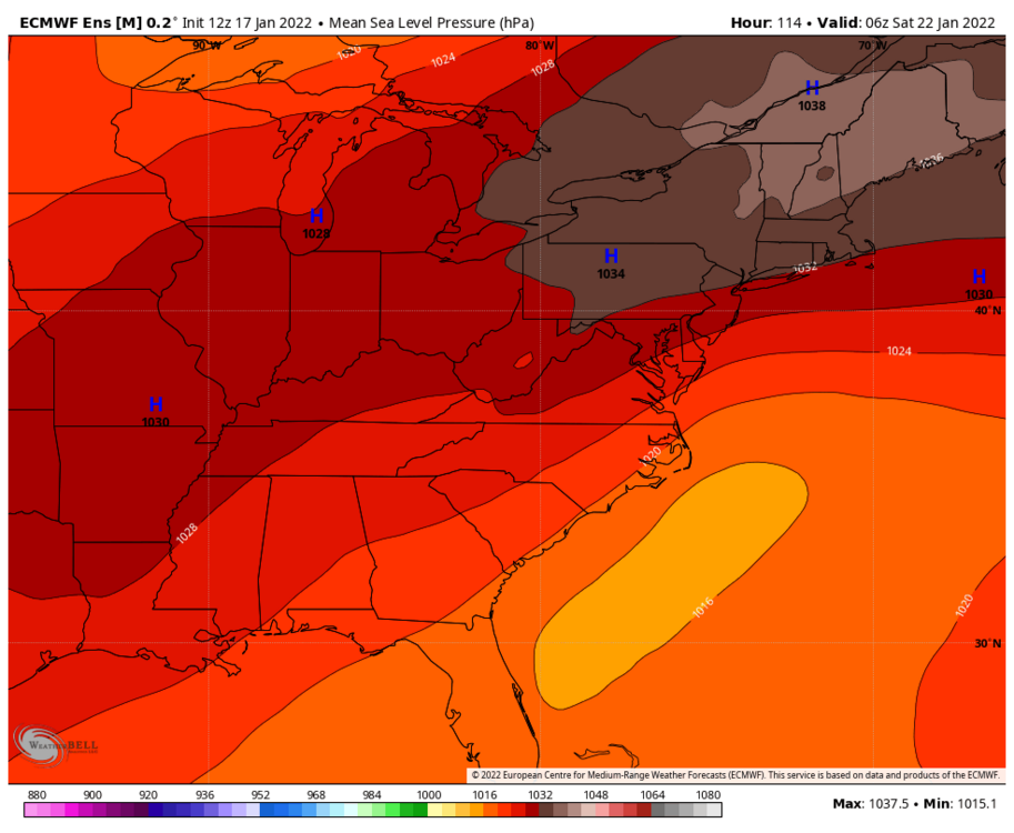
Both the ECMWF Ens (M) and (C) have improved for my area over last three runs. Small changes but certainly gotten better
-
2
-
-
I actually think things improved well for the Triangle on the 6z model outputs. Coupled with last night's runs there is less threat of a major ice storm and trend to more snow/sleet. 6z EPS shows a move towards gfs
-
1
-
-
Just now, lilj4425 said:
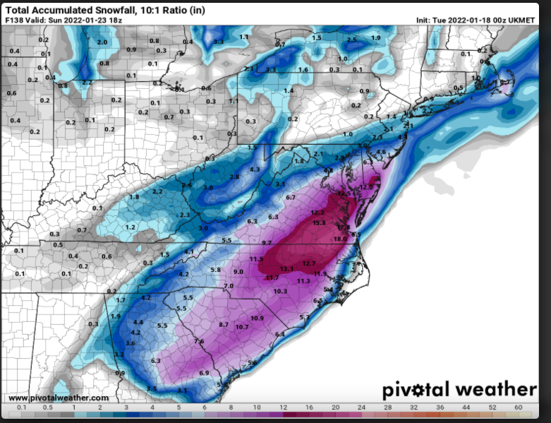
I fully expect the Euro to come in line with the Ukie with the next model run. They usually follow in tandem with each other.
maybe, but UK could cave tomorrow if euro holds on it's solution too
-
I'll just leave this here right now
-
6
-
-
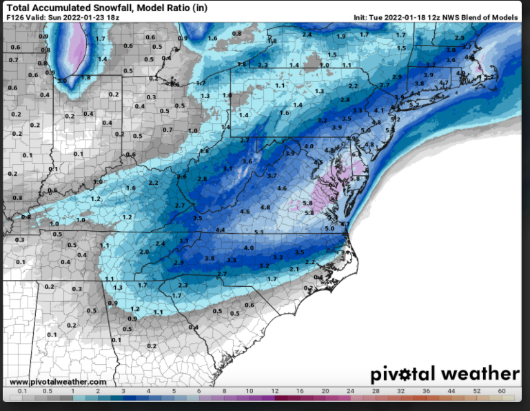
UKMET is a snowbeast dream!
-
1
-
-
19 minutes ago, burrel2 said:
Probably a lot of sleet and freezing rain... I don't know, but i'm staying up for the more detailed maps because it looks so juicy.
Bring the goods.
-
2 minutes ago, StantonParkHoya said:
CMC with 6 inches for most of Wake County. Pretty straight forward, and similar to 12z.
Noticed the 540 line on the CMC dancing over Wake co. Mixing a bit there you think?
-
Won't be up for it but would love the euro to tac back a little towards the gfs and cmc
-
2
-
 1
1
-
-
Looks colder and less amped than the earlier euro run. Less precip. maybe? but still decent. Not overwhelming ice
-
Just now, Ghicks said:
Million dollar question who will cave to who? Will the nw trend continue or will euro cave to gfs
Let's see the CMC
-
2
-
-
Well now we have suppressed and amped among the leaders in the LR. Maybe the midnight runs can sort it out but have a feeling it will be Tues night (Weds 0z) runs
-
1 minute ago, Wow said:
Watch the energy which is trying to phase into the southern s/w.. it's trended faster recently but if it starts reversing that trend it's going to be a bigger phase... e.g CMC/Euro runs from late Sat/early yesterday
Ok, confused again. Faster phase means more ice in central NC/SC right?
-
1
-
-
4 minutes ago, eyewall said:


The Euro doesn't really separate the two waves where as the GFS does. The Euro develops a single low and bombs it out as phasing occurs. The GFS has a more distinct separation and delays the second vortmax a bit resulting in the weak impulse first with the FROPA followed by the main wave late in the weekend. Of course as mentioned, we know the strength of the SE ridge will play a key role here as well.Let's see if the 18z gfs still has it (2 waves) that way. Any chance the euro has this wrong?
-
4 minutes ago, Beach Snow said:
Agree, but the further east the low is less likely the 850s creep inland…i think.

Sorry was referring to the path of the ULL 850 across Ga/SC and NC
-
1
-
-
Just now, Beach Snow said:
Most LP are well offshore compared to OP
It's that pesky 850 track though Beach


January 20-22 “bring the mojo” winter storm threat
in Southeastern States
Posted
Kind of what I'm expecting but wishcasting a jog of 850s further south and east