

CaryWx
-
Posts
2,667 -
Joined
-
Last visited
Content Type
Profiles
Blogs
Forums
American Weather
Media Demo
Store
Gallery
Posts posted by CaryWx
-
-
1 minute ago, snowmaker13 said:
It amazes me that NCEP hasn't incorporated AI into their modeling while virtually every other industry is incorporating it. I'm pretty sure Deep Learning modeling can drastically increase accuracy.
More funding?
-
1 minute ago, eyewall said:
or keeping the viewership until they finally have to walk it down
")
Tend to believe what ilmRoss posted about baking in that nw trend. Usually do not see less west of me so may be underdone despite models
-
5 minutes ago, NorthHillsWx said:
^^^this. We were looking at a 1-3” sleet storm 2 days ago now, a 2-4” snowstorm with arctic air and high ratios. I see nothing cataclysmic from the modeling at this point. Definitely on edge but we’re still in a good spot
Yeah, feel like the Triangle is almost playing with house money here to a certain extent
-
 1
1
-
-
4 minutes ago, Brick Tamland said:
He might end up being right, but nothing on the models suggested anything he has been saying until this morning. Up until now all the globals were pretty much the same with the storm the last couple of days. I think he's been doing some bittercasting during this one for some reason.
He could and betting the sleet-streak for Raleigh is not unwise. That said there was a slight expansion back west on the gfs from 06z but not really a nw trend that I could see.
BTW, that snow chances chart from WRAL has a 52.5% chance of being correct.
")
-
 4
4
-
-
Just now, ILMRoss said:
jeez everyone totals were cut but still looks like a fine storm and we haven't even gotten to the GFS; feels like a funeral in here
closed casket please
-
1
-
-
16 minutes ago, Sandstorm94 said:
Lol the HRRR pops a low over the Apps from the front
Sent from my SM-S115DL using Tapatalk
Yeah, think that was expected. Gives some that fropa snow tomorrow evening, but many just get a shower
-
Not crazy about these northwest jumps and 850 lines creeping back
-
1
-
-
Could just about throw a wet snowball into the sleet zone from Cary
-
1
-
-
30 minutes ago, lilj4425 said:
The NAM just caused me to open a beer.
Made me think of this. Fearing trend northwest now.
-
3 minutes ago, NorthHillsWx said:
Only saving grace is the freezing line is offshore the coast and down to savannah Georgia and If taken verbatim then every corner of wake county has a least 5 inches of frozen on the ground after the storm…
Oh I know that line could waffle and slide to and fro during the actual storm. What we don't want to see is it shift slowly northwest on the coming model runs
-
3 minutes ago, NorthHillsWx said:
So, how bout that almost 6 inches of sleet. You think that would stick around till March?
ugh, that Wake county gradient. Is it done at 84?
-
1
-
-
-
13 minutes ago, ILMRoss said:
Going to put on my pessimistic hat on for a second... (I don't like making these posts so this is the only one I'm doing for this storm...)
The snow maps for the triangle are beautiful. Lovely. It's a picturesque spike that punctures straight through Wake County. I'll tell you how I'm interpreting it right now- I'm mentally taking it and shoving it 30 miles to the north. I've sat through so many of these storm threads and seen Wake County in a lovely position just to see sleet. I've been snakebitten so. many. times. We are consistently finding new ways to end up with sleet. So as I see more of these perfect snow maps the pit in my stomach just grows larger.
I'm currently put off by how skinny and shaky the modeled snow corridor is, it really leaves no margin of error. If our system ends up weaker and strung out, the snow corridor isn't simply shoved south- it will shrink with decreased lift and precipitation will struggle to get past, say, highway 1. A stronger version of our current system will likely shift the sleet line north of Wake County. Raleigh folks: we look good right now but man I don't like this tenuous balancing act.
What I'm looking and hoping for tonight is our northern shortwave somehow beefing up a little more- dropping down with a little more pep in its step- and being able to dig south more. qpf wouldn't be an issue and I think this would depress heights enough to make mixing in the triangle way less of an issue.
It does look like a little of your hope might be happening on the 0z NAM. Not a lot, but some
-
1
-
-
1 minute ago, PackGrad05 said:
WRAL's futurecast high res shows nothing Thursday night but mixed precip starting Friday morning. Mix of sleet, snow, freezing rain according to their current forecast.
Points out european being more robust but american showing another round saturday.When I think about the coverage area they have to account for there will be vast differences between say Goldsboro, Southern Pines, Roxboro and Rocky Mount. Then there is Wake county. They'd need to issue micro forecasts
-
Looks like next Weds..ish
-
1 minute ago, ILMRoss said:
He's fine. He throws enough models/jargon around to give off a "hey kid, let me show you what's really going on" kind of vibe but explains it well enough to be accessible to the public. He can be a jerk but I think people actually kind of like that schtick sometimes. But I think he generally knows what he's talking about and my Richmond friends really like him. I think every region has "their guy". For CLT it is Panovich. For a while in RDU is was Fish. For RIC I think it's DT moreso than a lot of the broadcast people simply because he's been savvy on social media for a decade now. I also like his snow map designs... Usually pretty clean and easy to read (but usually about 20% overdone lol)
Wish he would incorporate more spellcheck products into his forecast
-
2
-
2
-
-
Kind of confused by that 18z NAM run. Seems like it went off point from 12z and dampened out a bit more. Although looking at 84hrs is a non-no for stuff like that.
-
What timeframe?
-
1
-
-
UK is usually to far south for it's bias right? If this comes north--whoowee schwing!
-
4
-
-
Just now, btownheel said:
and let's be real here (with much love to the SWVA and mountain crew) those guys cash EVERY winter event that we get warm nosed on.
They'll live.
Heck, they are probably in for a few more solid hits this winter anyway.
-
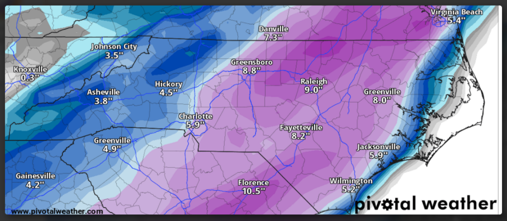
1 minute ago, VABILLUPS1 said:
I'm under that 21 in Va. Beach so, yeah, nice run. I'll sign for a quarter of that right now.
I'm sure it's overdone even in the best of times but gives you an idea what could start happening if ratios go above 10:1 for a bit
-
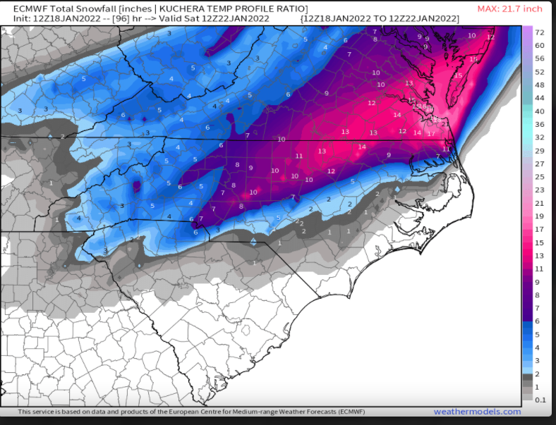
1 minute ago, Brick Tamland said:
Anyone have the Kuchera for the Euro? I think it would have even bigger totals.
Accounts for fluffier ratios
-
2
-
-
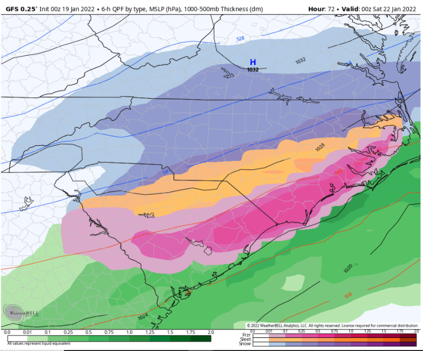
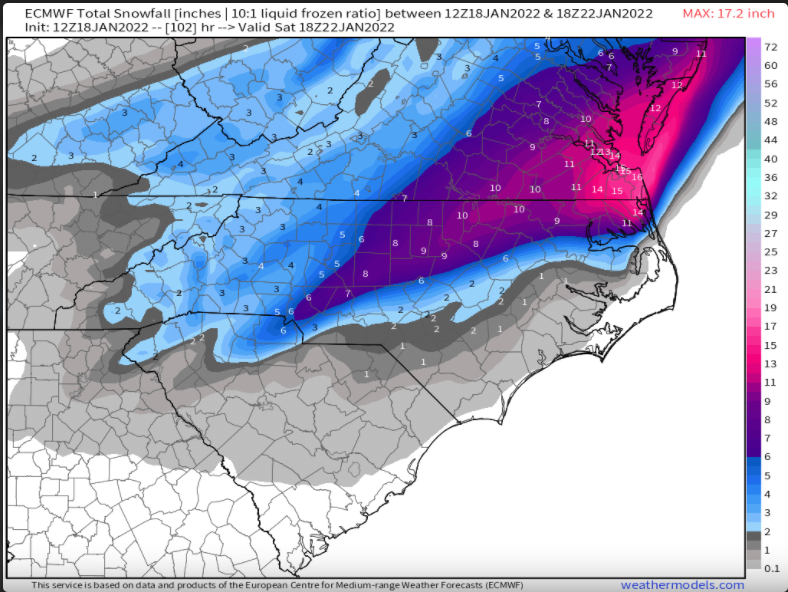
1 minute ago, wake4est said:
I'd love to see the sleet and ice maps for SENC
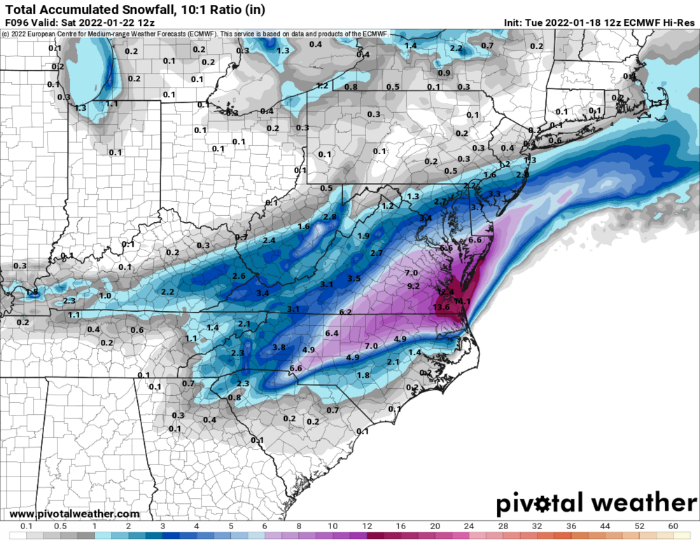
Try this one at 102
-
1
-
-
Just now, Ghicks said:
Model maddness 2022 again why not
There's more alignment than you think, especially up around Norfolk area
-
1
-


January 20-22 “bring the mojo” winter storm threat
in Southeastern States
Posted
12z Thursday for a resolution on 24hrs out is a bit insulting from a weather forecast model perspective isn't it?