

CaryWx
-
Posts
2,667 -
Joined
-
Last visited
Content Type
Profiles
Blogs
Forums
American Weather
Media Demo
Store
Gallery
Posts posted by CaryWx
-
-
15 minutes ago, HKY_WX said:
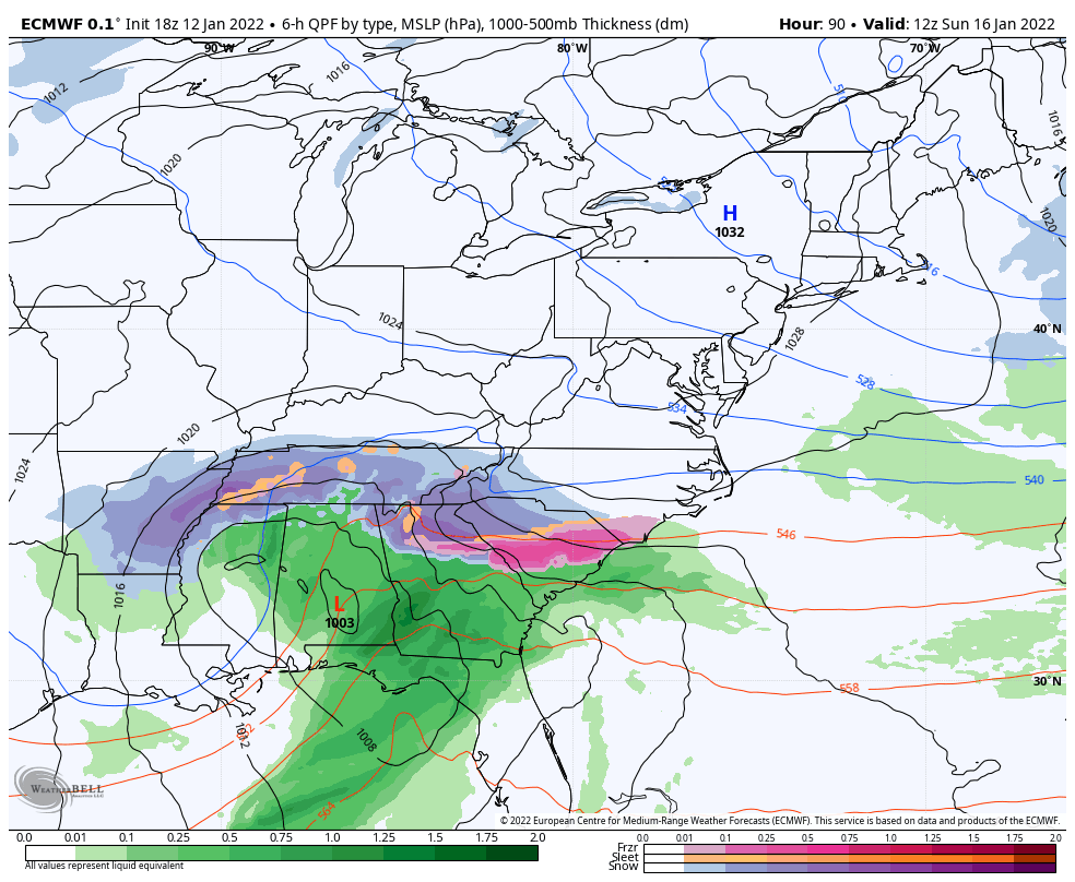
The NAM is a realistic projection given the strength of the upper low. It's not truly a miller A if you look closely. There will be a surface/mid level slp reflection over the northern deep south which will throw those SE winds aloft (thus warming up mid-levels and causing sleet/zr). Still trying to see a way RDU doesn't changeover to rain but it's looking likely for a least a few hours given the strength of the coastal front. I do think it's possible we continue to see a trend SE due to the anomalous nature of the projection. It's not often you see Myrtle Beach get ZR and Raleigh changeover to rain. Makes me inclined to think there are some additional shifts to come and the models may be underestimating the cold dome/depth of the cold air.
Thanks HKY but our problem in the RDU area is not helped much by the south trend as this low just will not track far enough east once it turns up the coast no matter how far south it trends. I don't see that changing or even being influenced to change much based on these new "south" trends
-
This where the euro and it's ensembles are going to be looked to. Do they trend se?
I just cannot stay up that late
-
0z GEFS gonna be better than 18z GEFS looks like
-
 2
2
-
-
4 minutes ago, Wow said:
GEFS following the same trend
As the GFS 0z op?
-
That ICON run show the massive zr we would get in the Triangle from that run?
-
1026 HP isn't so stout as other depictions. 1034 and even 1040 albeit they were in higher latitude locations on other runs
-
With the NAM I always thought focusing on precip. amounts and temps (bl and maybe 850) beyond about 48hrs is not too reliable. Use it for the large feature movement trends
-
At least we're not in Tennessee any more
-
1
-
 1
1
-
-
3 minutes ago, lilj4425 said:
Hopefully less WWA which would mean more snow rather than sleet and freezing rain.
WWA Gracie? Don't you mean WAA. If it rains we get less WWAs.
")
-
So from there it progs eventually to transfer around Savannah and move up just inland right? We need it to move east more before turning
-
4 minutes ago, Sandstorm94 said:
0z NAM just started... Now the fun begins
Sent from my SM-S115DL using Tapatalk
Will this show the transfer you think?
-
3 minutes ago, JoshM said:
Too bad euro ends at 90hrs, that’s a weenie run

Just need to see where that LP transfers to. Next 6hr frame but alas it ends at 90 <sigh>
-
4 minutes ago, BIG FROSTY said:
He's still around looking for some snow!
")
Hi newbie! You're going to do well on this storm.
-
2
-
2
-
-
1 hour ago, burrel2 said:
Call me crazy but I think the 18z gfs makes a huge shift south.
Show us this trick again!
-
2
-
2
-
-
21 minutes ago, Sandstorm94 said:
Brace yourselves darlings...

Sent from my SM-S115DL using Tapatalk
I may have to clutch my pearls if it does this shift again on the 0z
-
1
-
2
-
-
3 minutes ago, Sandstorm94 said:
Boom

Sent from my SM-S115DL using Tapatalk
The Op run took the top of the inner circle but the GFS center plot mean looks off Myrtle Beach
-
4 minutes ago, Sandstorm94 said:
GEFS has the LP center scatter plot east of 12z
Sent from my SM-S115DL using Tapatalk
Be interesting to see where the scatter plot has the transition LP evolve.
-
Some folks getting back into the game this run
-
2
-
-
Just now, AsheCounty48 said:
Improvements on the GFS. looks like the energy transfer happens a bit sooner for the developing low, and everything appears to basically be shoved 50 miles ESE from 12z.
My thought too. That LP was evolving just east of Raleigh at one point
-
2 minutes ago, Wow said:
Big improvement with the gfs .. less amped with the primary low . The hope is we can erase this trend over the past 24 hrs.
Where are we getting the transition miller-B Wow? Looks over Wilmington now as opposed to much further north earlier
-
Hadn't really begun to look past this weekend but we have some legitimate conditions through the end of the month to get at least one more shot
-
2
-
-
22 minutes ago, ILMRoss said:
Want to mention something. This is my 11th winter on this board. I've seen so many catastrophic model zr maps. I mean, so many. Every single storm has catastrophic ice storm maps. And yet our benchmark is still Dec. 2002. It seems that once the storm comes, the icy zone always seems to narrow considerably, with sleet or rain cutting into it, and wherever that zone ends up shifting wildly. After all of this, point being: I do not put any stock on model ZR maps until maybe like 12 hours before the event. I do not want to seem like I'm downplaying the threat. Do I still stock up on ravioli I can eat straight from the can? Yes. But just be careful. I think ice maps are magnitudes more unreliable than snow maps.
Important point to bring up Ross and I agree. In fact I posted on another board about the longer range models ability to even semi-accurately predict such an ice accrual forecast. Let alone a meteorology scientist intuitively interpreting that data to forecast in the longer range. It's such a thin area (zr) of the precip medium (between sleet and rain) that the probabilities of predicting locations for either of these other two is far more reliable
-
Looks like a big damn mess to me
-
 2
2
-
2
-
-
Eric Webb says it ain't happening
-
2
-
Southern Sanitarium
in Southeastern States
Posted
So does everyone believe we're ok for the most part in the triangle with regard to power outages? Not really making any special plans for Sunday to cope as I just don't see it as a problem in Cary. Just a messy day