

CaryWx
-
Posts
2,765 -
Joined
-
Last visited
Content Type
Profiles
Blogs
Forums
American Weather
Media Demo
Store
Gallery
Posts posted by CaryWx
-
-
10 minutes ago, wxdawg10 said:
By that same logic, Mets should have gone all in when every model was showing a historic blizzard a week ago? see how that works? Model data is not absolute. Common sense exists in forecasting too. Something models don't have. so yes, the warmnose always over performs in this set up.
apples & walnuts. Poor comparison, but I'll just leave it at that.
-
 1
1
-
 1
1
-
-
1 minute ago, eyewall said:
History shows more times than not the warm nose makes more progress than modeled.
So by that logic if no models were showing a warm nose in the area then mets would still forecast a warm nose somewhere?
-
Be nice if the 18z GEFS can also have the 850s south of Wake county
-
 1
1
-
-
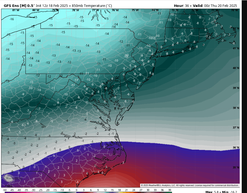
8 minutes ago, GaWx said:
Thanks. However, this map is from the GEFS rather than the GFS. You mentioned the GFS and it is colder.
You had said: “12z gfs looks like nam-12km as well with 850s up in northern wake”
I stand corrected. It's an ensemble mean
-
 1
1
-
-
14 minutes ago, GaWx said:
Do you have a 12Z GFS 850 mb map showing this? I’d like to see it. At 3 hour intervals (based on cross checking Pivotal), this TT GFS 850 map (hour 30) is the warmest at Wake and 0C is almost as far S as the S Wake border leaving RDU at -1C:

Eric dropped this one in another place...
It's also a mean at 36
-
10 minutes ago, GaWx said:
Check out how much colder is the 3 km vs 12 km 12Z NAM at RDU:
3 km: <0C at 850 at 4PM, similar to globals

12 km: >0C at 850 at 4PM, warmer than globals; it has a 2 mb stronger surface low and the low is quite a bit N of 3km position

12z gfs looks like nam-12km as well with 850s up in northern wake
-
 1
1
-
-
2 minutes ago, GaWx said:
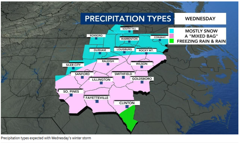
I still don’t see much if any mixing of non-snow precip in the RDU area. This looks like a classic practically all snow Miller A there imo. 850s look to stay safely <0C from what I’ve been seeing. You may even get a little higher than 10:1 ratios of snow.
The NAM looks like lots of mixing but maybe I'm not looking at the latest one.
-
RDPS colder? ICON less precip?
-
Agree, hadn't seen any predominant zr precip. proggs for Wake county. So not sure what RAL sees.
-
Just now, NorthHillsWx said:
I mean from modeling that seems very reasonable and in fact you could even move the mixed bag area further north if NAM thermals are your thing…
Yet there is this on their website too...
-
From WRAL...
-
1
-
-
2 minutes ago, Orange county said:
WRAL at lunch says Raleigh will be ice. WTVD says snow in Raleigh and ice line further south
Ice as in zr?
-
18 minutes ago, BooneWX said:
For sure. I have a ton of respect for GSP - that’s why I said I would like to have heard some of those conversations that led to the decision given the guidance - wasn’t questioning their thought’s themselves. Would’ve been nice to be a fly on the wall as a weather nerd.
check the latest gefs numbers out there
-
22 minutes ago, wncsnow said:
Models are also starting to weaken the confluence in the NE along with having a weaker system. There is less cold out ahead of the storm.
I'm not seeing that across the models. Even the nam had a better cold press this last run
-
2
-
-
1 minute ago, BornAgain13 said:
Hey yall did I miss anything? Lol
getting buried maybe
-
1
-
-
1 minute ago, olafminesaw said:
Canadian is all over the place, makes it difficult to take stock in
took slp more off the coast this run
-
1
-
-
Just now, olafminesaw said:

That's fairly tolerable albeit some power hits.
-
1
-
-
6 minutes ago, NorthHillsWx said:
I think the triangle area is at its highest risk of a devastating ice storm since December 2002
I'll buy that... but better bet is mixy sleet storm or cold rain
-
Just now, BooneWX said:
Also, something that smells fishy to me that I’ve seen all day. You could technically have freezing rain simultaneously in Fayetteville and Hickory, I guess, but I can’t drum up a single scenario in the past where that has happened. It’s either unprecedented or these models are all out to lunch.
The broad field depictions are suspect for sure
-
1
-
-
4 minutes ago, GaWx said:
1) As just mentioned it had very heavy (historic in some cases) snow on several runs in a row very far to the south (as far S as NE GA, upstate SC) for earlier this week, for example.
2) For the Jan 10-11 storm, it had warming S winds ahead of the N Gulf low on the backside of the high moving offshore and ahead of a Clipper. That hardly ever happens. It ended up dead wrong at the surface.
3) I’m not disputing what you’re saying, but I don’t know exactly what you’re referring to and what exactly the verification measures. It could have been an H5 verification for all I know. The main problems may lie underneath 500 mb. Do you have a link or can you post the graphics?
4) I’m not saying it couldn’t end up right with the very suppressed track. With the preceding -5 AO, it could occur. What I’m saying is I’m taking it with a huge grain while it is on its own.
5) Are you favoring this very suppressed track?
I don't have specifics but I've seen charts posted where it is rated pretty well. You are correct in 'what are the specifics it scores well in?' and at what range (which I mentioned here)
No, I do not see a suppressed track verifying. I do suspect a further north (Va) centralized placement with this storm. Just been the case this season. All anecdotal thinking for sure, but wouldn't surprise me in the end.
-
1
-
1
-
-
3 minutes ago, GaWx said:
The Euro AI has not been good overall this winter imo as I just posted. It especially blew the most recent storm’s snowfall, way overdoing it with 850 0C line way too far south and thus having historic snow amounts way far south of the actual snow line. So, I’m taking this very suppressed 12Z Euro AI with a gigantic grain at this point:

I thought it had good verification scores. This would be range dependent though. 3-5days?
-
No 12z euro run for you!...
Come back. 6hrs.
-
6
-
-
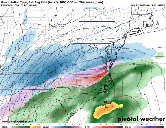
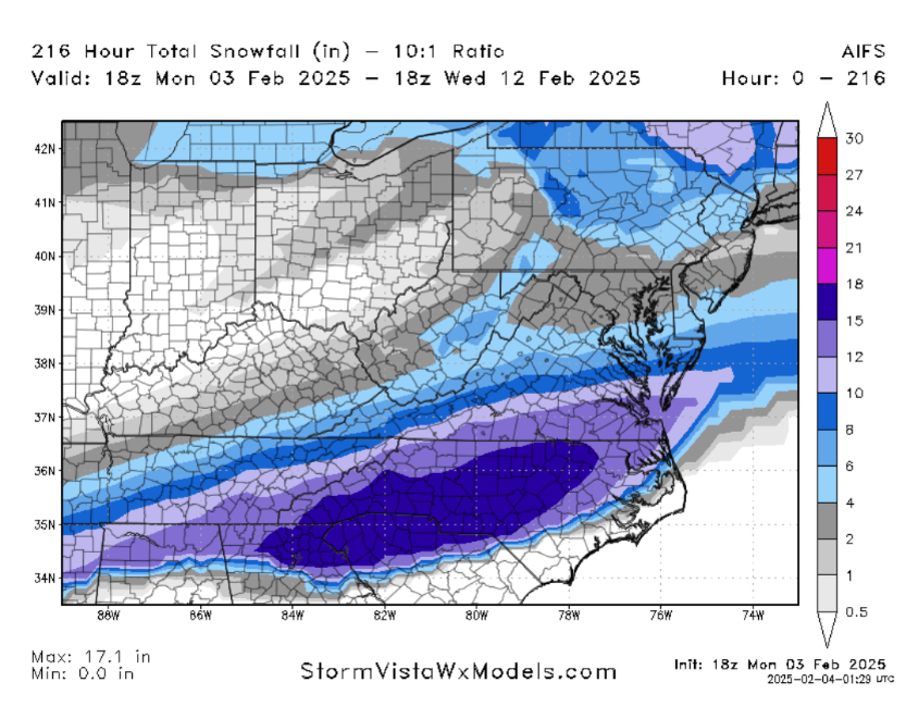
8 minutes ago, tarheelwx said:
IS any of that on the southern edge actually ice? Or, is there additional ice to the south side of what's shown on the 216 snowfall map above?
TW
Wouldn't surprise me. This would be overrunning I believe.
-


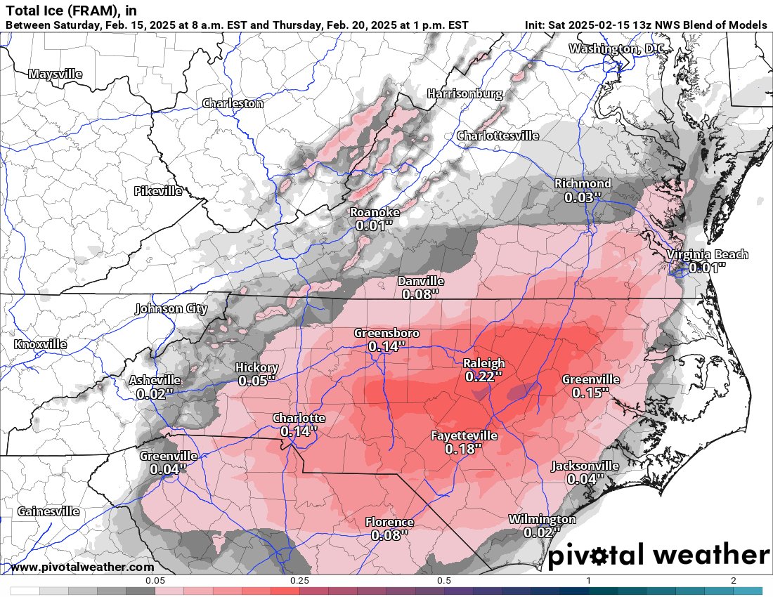

February 19-20 Major Winter Storm Threat
in Southeastern States
Posted
Inside 8hrs which tends to be more reliable RAP or HRRR?