

CaryWx
-
Posts
2,667 -
Joined
-
Last visited
Content Type
Profiles
Blogs
Forums
American Weather
Media Demo
Store
Gallery
Posts posted by CaryWx
-
-
EPS is saving eastern NC right now. Operational euro way too amped as you can see the amounts on the control . EPS mean still looks fairly solid.
-
850 track screws a lot NC below I85 looks like?
-
 1
1
-
-
23 minutes ago, cbmclean said:
Sometimes that's the only valid thought to have, if there isn't enough data to come to a conclusion.
yeah, but holy cow there's a heck of a lot more data than that. Pretty sure this is more than just "innocent cold fropa". Now who gets what kind of precip and where?--Sure that's only really known to the Gods right now.
-
 2
2
-
-
Just now, TARHEELPROGRAMMER88 said:
Cold rain?
Not really
-
1
-
-
Given storm placement and development among the various models not a bad look overall on the blended I bet.
-
Just now, burrel2 said:
comparing 12z Rgem and 00z CMC, the new rgem is has more fully incorporated the baja low and led to a much sharper trough. Gulf low already organizing off the texas coast as a result.
Is the sharper trough good or bad? Sorry still drinking coffee
-
37 minutes ago, ILMRoss said:

To me, I think that the battle lines are set today. Going to use the Canadian from last night because it's a good example of our "dudes out on the field". The northern energy drops in from the plains. We want this energy to be stronger and nudging further to the SW; our dud runs are when this trough stays too positively tilted and just can't get anything to pop. The southern energy comes from Cali/Arizona and we want it to be quicker; our dud runs come when it's held back. It's a shame that we have to deal with this because Baja/Mexi lows have the predictability/reliability of orange cats (you know the type).
So far it seems a host of solutions are on the table. The runs where the Zona shortwave is held back make this plains shortwave dominant and we just have to hope it is digging enough/strong enough to pop something.
The runs where the Zona energy kinda mingles with our northern stuff (saw this with Canadian) will be murky. The end product would depend on how cute the models get with fluid dynamics but generally it looks like the trough would be large/south enough to bring some good moisture transport but positively tilted/sheared enough to cause ptype issues. 1.28.2014 is the obvious analog here.
The runs where the Zona energy comes together in melodious harmony with our northern energy (yesterday's 12z Canadian) would be iconic southeast winter events.
Famous last words here but the surface temps shouldn't be an issue with this cold press.
Thanks Ross. This is good knowledge to have. When it comes to Raleigh though for the upcoming storm what is looking like our culprit for mixing issues? Is it the low track with 850 warm nose this time? Goodness we have the cold setting in and would think it deeper/better press than this past weekend and we are not getting some crazy wind-up storm like just went through. This is overrunning more or less right?
-
We won't get torchy but track dependent for zr/ip in the Triangle
-
1
-
-
It's not good for RDU
-
 1
1
-
-
2 minutes ago, BIG FROSTY said:
It's workable from there. Nice run!
Aren't you outside making snow angels?
-
Just now, Brick Tamland said:
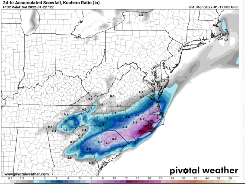
Looks like high ratios with the Kuchera output showing more than the 10:1 output.
If it's up here in the Triangle it will be fluffy with our cold temps
-
Just now, StantonParkHoya said:
Maybe I’m an ass, but if we miss here, I’d rather miss it where coastal folks get it rather than foothills crowd.
My thinking too. If we miss let it be east to the Coastal folks
-
2
-
-
Errr, right where we want it?
-
1
-
-
Man it's cold!
-
-
It's a near miss? Still though, sure looks like some energy running along that southern stalled front
-
How good was the ICON on this last system?
-
flizzard in Cary
-
1
-
-
suppressed and un-amped. I'm good for 6 days out
-
3
-
-
8 minutes ago, TARHEELPROGRAMMER88 said:
No, the discussions are pertinent to the future progression of the coming cold rain storm. If we could erase the current thread for it and have you start a new one it would be assured :+)
We don't know this yet and the spread is quite large for someone to get a win here
-
1
-
 3
3
-
-
25 minutes ago, Sandstorm94 said:
Tropical Tidbits now has the 6 and 18z Euro out to 72hrs
Sent from my SM-S115DL using Tapatalk
Is 18z euro out yet?
-
The track of that 2nd wave on the 18z GFS look similar to todays in that it turns up on the coast in SC. If I'm seeing that right.
-
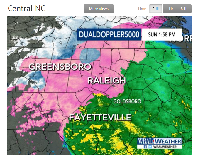
Quick radar snapshot of how things look in NC
-
1
-
-
Just went to 33 at my location so going to avoid zr which is good
January 20-22 “bring the mojo” winter storm threat
in Southeastern States
Posted
Here's the eps mean over last 4 runs. Seems to hold well still if I'm reading it right. Look at the 0-line.
Last four runs of the ECMWF EPS valid 12z Saturday.