

CaryWx
-
Posts
2,832 -
Joined
-
Last visited
Content Type
Profiles
Blogs
Forums
American Weather
Media Demo
Store
Gallery
Everything posted by CaryWx
-

January 20-22 “bring the mojo” winter storm threat
CaryWx replied to lilj4425's topic in Southeastern States
It's a near miss? Still though, sure looks like some energy running along that southern stalled front -
January 20-22 “bring the mojo” winter storm threat
CaryWx replied to lilj4425's topic in Southeastern States
How good was the ICON on this last system? -
Winter Storm Izzy Obs Thread
CaryWx replied to Prismshine Productions's topic in Southeastern States
flizzard in Cary -
suppressed and un-amped. I'm good for 6 days out
-
We don't know this yet and the spread is quite large for someone to get a win here
-
Is 18z euro out yet?
-
The track of that 2nd wave on the 18z GFS look similar to todays in that it turns up on the coast in SC. If I'm seeing that right.
-
Winter Storm Izzy Obs Thread
CaryWx replied to Prismshine Productions's topic in Southeastern States
Quick radar snapshot of how things look in NC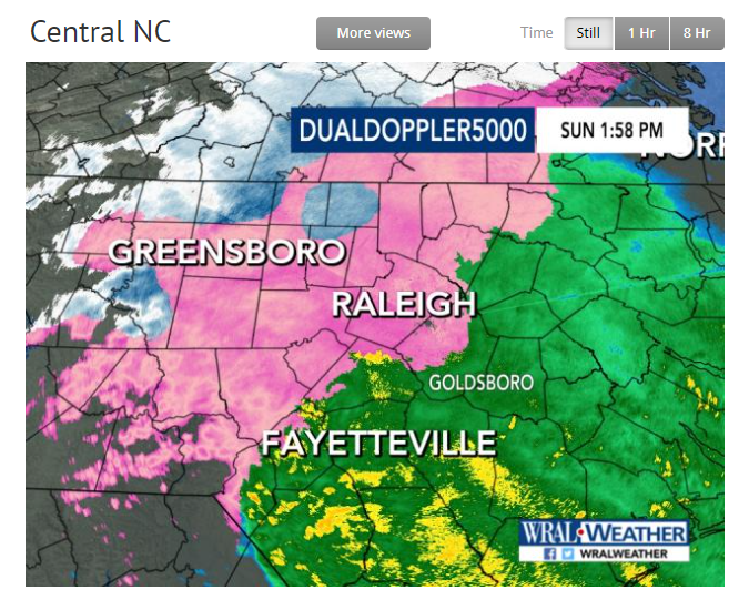
-
Winter Storm Izzy Obs Thread
CaryWx replied to Prismshine Productions's topic in Southeastern States
Just went to 33 at my location so going to avoid zr which is good -
What we want to see actually on some of the model runs at this range.
-
Winter Storm Izzy Obs Thread
CaryWx replied to Prismshine Productions's topic in Southeastern States
However Boone doing very well King St webcam -
Winter Storm Izzy Obs Thread
CaryWx replied to Prismshine Productions's topic in Southeastern States
Me too. Prefer a bit less of zr for everyone but otherwise peeps to our west in NC, upstate SC, and even parts of North Ga doing very well. -
Winter Storm Izzy Obs Thread
CaryWx replied to Prismshine Productions's topic in Southeastern States
Yeah, just a bit in the wrong place -
Winter Storm Izzy Obs Thread
CaryWx replied to Prismshine Productions's topic in Southeastern States
Man, that looks tough -
Winter Storm Izzy Obs Thread
CaryWx replied to Prismshine Productions's topic in Southeastern States
Where are you? -
Winter Storm Izzy Obs Thread
CaryWx replied to Prismshine Productions's topic in Southeastern States
Really? In Wake county? Not according to radar. zr still east of I95 -
January 20-22 “bring the mojo” winter storm threat
CaryWx replied to lilj4425's topic in Southeastern States
I think after we get through today's storm. -
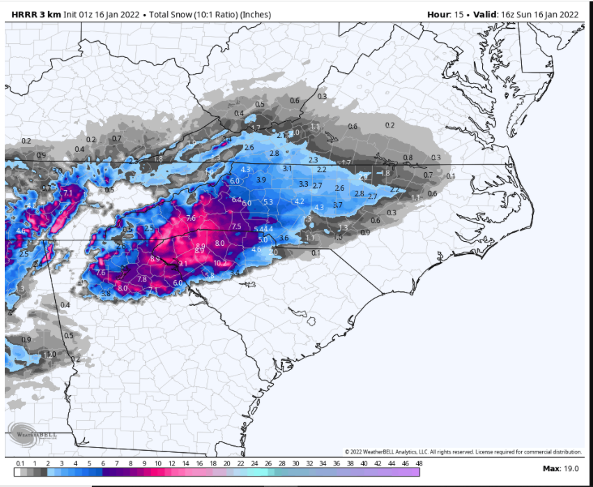
HRRR also bringing a little more snow east.
-
Latest 3k NAM took ice accums down a little in the Triangle Bull
-
Consider ourselves lucky this go around
-
Yeah kinda re-enforces the CMC run from earlier. Talk about board wide wins
-
That has my curiosity up as well
-
Wouldn't consider it much more than a cool pic at this point. If it is anywhere close to this come the 96hr mark than yes-Big Conversation
-
I think that crescent-moon metro shaped area in NC from about Hillsborough through Greensboro/High Point down to Charlotte/Rock Hill is in for some nasty. Get prepared folks
-
January 20-22 “bring the mojo” winter storm threat
CaryWx replied to lilj4425's topic in Southeastern States
Well, in for a penny in for a pound now


