CaryWx
-
Posts
2,832 -
Joined
-
Last visited
Content Type
Profiles
Blogs
Forums
American Weather
Media Demo
Store
Gallery
Everything posted by CaryWx
-

January 20-22 “bring the mojo” winter storm threat
CaryWx replied to lilj4425's topic in Southeastern States
Noticed the 540 line on the CMC dancing over Wake co. Mixing a bit there you think? -
January 20-22 “bring the mojo” winter storm threat
CaryWx replied to lilj4425's topic in Southeastern States
Won't be up for it but would love the euro to tac back a little towards the gfs and cmc -
January 20-22 “bring the mojo” winter storm threat
CaryWx replied to lilj4425's topic in Southeastern States
Looks colder and less amped than the earlier euro run. Less precip. maybe? but still decent. Not overwhelming ice -
January 20-22 “bring the mojo” winter storm threat
CaryWx replied to lilj4425's topic in Southeastern States
Let's see the CMC -
January 20-22 “bring the mojo” winter storm threat
CaryWx replied to lilj4425's topic in Southeastern States
Well now we have suppressed and amped among the leaders in the LR. Maybe the midnight runs can sort it out but have a feeling it will be Tues night (Weds 0z) runs -
January 20-22 “bring the mojo” winter storm threat
CaryWx replied to lilj4425's topic in Southeastern States
Ok, confused again. Faster phase means more ice in central NC/SC right? -
January 20-22 “bring the mojo” winter storm threat
CaryWx replied to lilj4425's topic in Southeastern States
Let's see if the 18z gfs still has it (2 waves) that way. Any chance the euro has this wrong? -
January 20-22 “bring the mojo” winter storm threat
CaryWx replied to lilj4425's topic in Southeastern States
Sorry was referring to the path of the ULL 850 across Ga/SC and NC -
January 20-22 “bring the mojo” winter storm threat
CaryWx replied to lilj4425's topic in Southeastern States
It's that pesky 850 track though Beach -
January 20-22 “bring the mojo” winter storm threat
CaryWx replied to lilj4425's topic in Southeastern States
Here's the eps mean over last 4 runs. Seems to hold well still if I'm reading it right. Look at the 0-line. Last four runs of the ECMWF EPS valid 12z Saturday. -
January 20-22 “bring the mojo” winter storm threat
CaryWx replied to lilj4425's topic in Southeastern States
EPS is saving eastern NC right now. Operational euro way too amped as you can see the amounts on the control . EPS mean still looks fairly solid. -
January 20-22 “bring the mojo” winter storm threat
CaryWx replied to lilj4425's topic in Southeastern States
850 track screws a lot NC below I85 looks like? -
January 20-22 “bring the mojo” winter storm threat
CaryWx replied to lilj4425's topic in Southeastern States
yeah, but holy cow there's a heck of a lot more data than that. Pretty sure this is more than just "innocent cold fropa". Now who gets what kind of precip and where?--Sure that's only really known to the Gods right now. -
January 20-22 “bring the mojo” winter storm threat
CaryWx replied to lilj4425's topic in Southeastern States
Not really -
January 20-22 “bring the mojo” winter storm threat
CaryWx replied to lilj4425's topic in Southeastern States
Given storm placement and development among the various models not a bad look overall on the blended I bet. -
January 20-22 “bring the mojo” winter storm threat
CaryWx replied to lilj4425's topic in Southeastern States
Is the sharper trough good or bad? Sorry still drinking coffee -
January 20-22 “bring the mojo” winter storm threat
CaryWx replied to lilj4425's topic in Southeastern States
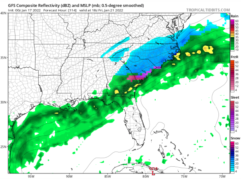
Thanks Ross. This is good knowledge to have. When it comes to Raleigh though for the upcoming storm what is looking like our culprit for mixing issues? Is it the low track with 850 warm nose this time? Goodness we have the cold setting in and would think it deeper/better press than this past weekend and we are not getting some crazy wind-up storm like just went through. This is overrunning more or less right? -
January 20-22 “bring the mojo” winter storm threat
CaryWx replied to lilj4425's topic in Southeastern States
We won't get torchy but track dependent for zr/ip in the Triangle -
January 20-22 “bring the mojo” winter storm threat
CaryWx replied to lilj4425's topic in Southeastern States
It's not good for RDU -
January 20-22 “bring the mojo” winter storm threat
CaryWx replied to lilj4425's topic in Southeastern States
Aren't you outside making snow angels? -
January 20-22 “bring the mojo” winter storm threat
CaryWx replied to lilj4425's topic in Southeastern States
If it's up here in the Triangle it will be fluffy with our cold temps -
January 20-22 “bring the mojo” winter storm threat
CaryWx replied to lilj4425's topic in Southeastern States
My thinking too. If we miss let it be east to the Coastal folks -
January 20-22 “bring the mojo” winter storm threat
CaryWx replied to lilj4425's topic in Southeastern States
Errr, right where we want it?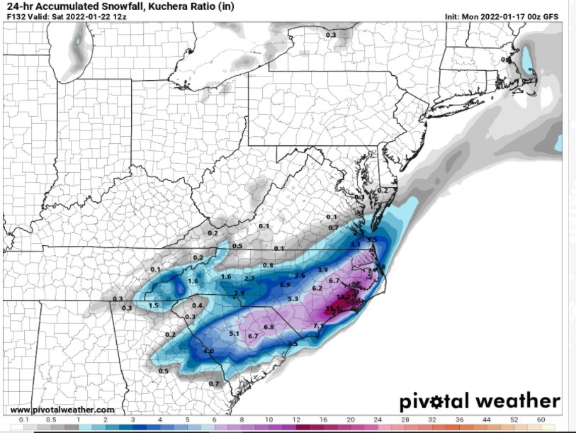
-
January 20-22 “bring the mojo” winter storm threat
CaryWx replied to lilj4425's topic in Southeastern States
Man it's cold! -
January 20-22 “bring the mojo” winter storm threat
CaryWx replied to lilj4425's topic in Southeastern States