

CaryWx
-
Posts
2,832 -
Joined
-
Last visited
Content Type
Profiles
Blogs
Forums
American Weather
Media Demo
Store
Gallery
Everything posted by CaryWx
-

January 20-22 “bring the mojo” winter storm threat
CaryWx replied to lilj4425's topic in Southeastern States
I would be careful here. Don't think we're going back o 3-6 in the Triangle...but we might -
January 20-22 “bring the mojo” winter storm threat
CaryWx replied to lilj4425's topic in Southeastern States
-
January 20-22 “bring the mojo” winter storm threat
CaryWx replied to lilj4425's topic in Southeastern States
Is it slowing down or speeding up in your opinion or about same pace? I do see the larger precip fields and denser moisture -
January 20-22 “bring the mojo” winter storm threat
CaryWx replied to lilj4425's topic in Southeastern States
Looks more amplified to me but LP further east than 06z? -
January 20-22 “bring the mojo” winter storm threat
CaryWx replied to lilj4425's topic in Southeastern States
Just watched WRAL 11pm weather. They have completely abandoned any snowfall amount predictions now Forget this chart we know it's old. What's odd is they did not even hazard to go with an updated one in the broadcast but rather punted to tomorrow morning. Sort of disappointed they backed off the courage to do that.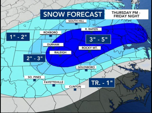
-
January 20-22 “bring the mojo” winter storm threat
CaryWx replied to lilj4425's topic in Southeastern States
"and" differentiator so it's ambiguous. (including the Triangle) could be referencing the former and not the latter. But it's petty for this thread. -
January 20-22 “bring the mojo” winter storm threat
CaryWx replied to lilj4425's topic in Southeastern States
Not Triangle the viewing area. I suspect points around Rocky Mount are going to get a bigger hit. I appreciated her info on why they didn't give in to the short range models right now. As always the northwest trend seems to happen in these parts. -
January 20-22 “bring the mojo” winter storm threat
CaryWx replied to lilj4425's topic in Southeastern States
I will sing their praises in the snow -
January 20-22 “bring the mojo” winter storm threat
CaryWx replied to lilj4425's topic in Southeastern States
Please tell me you're being a bit facetious here -
January 20-22 “bring the mojo” winter storm threat
CaryWx replied to lilj4425's topic in Southeastern States
12z Thursday for a resolution on 24hrs out is a bit insulting from a weather forecast model perspective isn't it? -
January 20-22 “bring the mojo” winter storm threat
CaryWx replied to lilj4425's topic in Southeastern States
More funding? -
January 20-22 “bring the mojo” winter storm threat
CaryWx replied to lilj4425's topic in Southeastern States
Tend to believe what ilmRoss posted about baking in that nw trend. Usually do not see less west of me so may be underdone despite models -
January 20-22 “bring the mojo” winter storm threat
CaryWx replied to lilj4425's topic in Southeastern States
Yeah, feel like the Triangle is almost playing with house money here to a certain extent -
January 20-22 “bring the mojo” winter storm threat
CaryWx replied to lilj4425's topic in Southeastern States
He could and betting the sleet-streak for Raleigh is not unwise. That said there was a slight expansion back west on the gfs from 06z but not really a nw trend that I could see. BTW, that snow chances chart from WRAL has a 52.5% chance of being correct. -
January 20-22 “bring the mojo” winter storm threat
CaryWx replied to lilj4425's topic in Southeastern States
closed casket please -
January 20-22 “bring the mojo” winter storm threat
CaryWx replied to lilj4425's topic in Southeastern States
Yeah, think that was expected. Gives some that fropa snow tomorrow evening, but many just get a shower -
January 20-22 “bring the mojo” winter storm threat
CaryWx replied to lilj4425's topic in Southeastern States
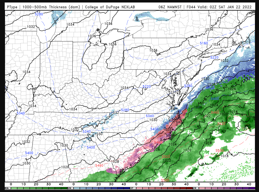
Not crazy about these northwest jumps and 850 lines creeping back -
January 20-22 “bring the mojo” winter storm threat
CaryWx replied to lilj4425's topic in Southeastern States
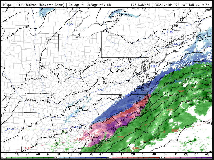
Could just about throw a wet snowball into the sleet zone from Cary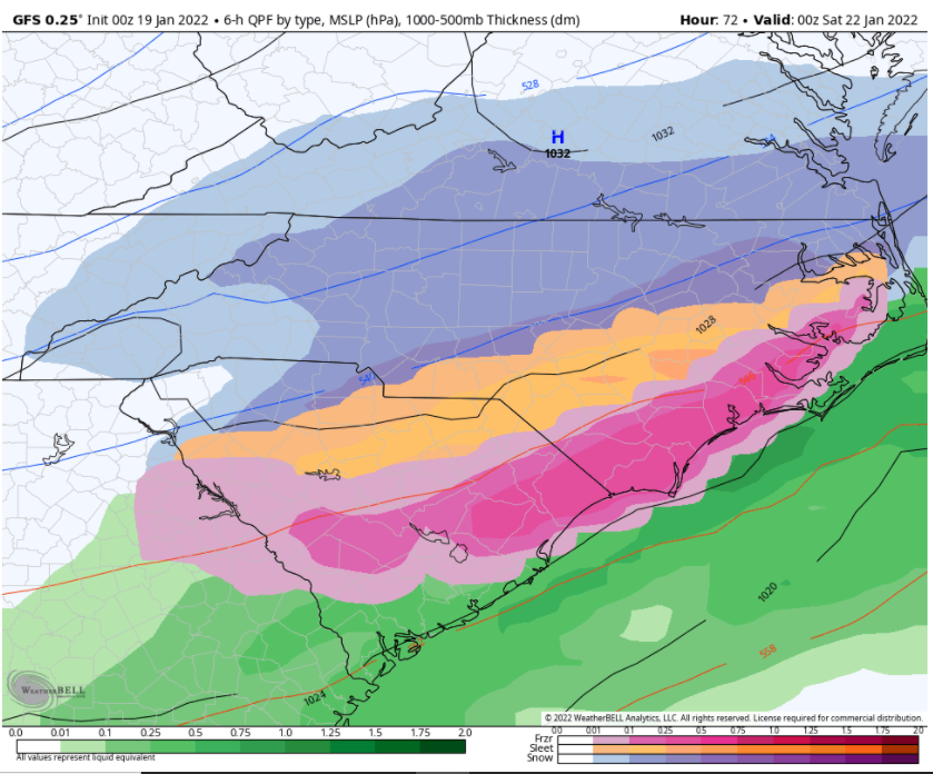
-
Made me think of this. Fearing trend northwest now.
-
January 20-22 “bring the mojo” winter storm threat
CaryWx replied to lilj4425's topic in Southeastern States
Oh I know that line could waffle and slide to and fro during the actual storm. What we don't want to see is it shift slowly northwest on the coming model runs -
January 20-22 “bring the mojo” winter storm threat
CaryWx replied to lilj4425's topic in Southeastern States
ugh, that Wake county gradient. Is it done at 84? -
January 20-22 “bring the mojo” winter storm threat
CaryWx replied to lilj4425's topic in Southeastern States
whoa -
January 20-22 “bring the mojo” winter storm threat
CaryWx replied to lilj4425's topic in Southeastern States
It does look like a little of your hope might be happening on the 0z NAM. Not a lot, but some -
January 20-22 “bring the mojo” winter storm threat
CaryWx replied to lilj4425's topic in Southeastern States
When I think about the coverage area they have to account for there will be vast differences between say Goldsboro, Southern Pines, Roxboro and Rocky Mount. Then there is Wake county. They'd need to issue micro forecasts -
Looks like next Weds..ish

