Terpeast
-
Posts
6,687 -
Joined
-
Last visited
Content Type
Profiles
Blogs
Forums
American Weather
Media Demo
Store
Gallery
Everything posted by Terpeast
-
Remember it like yesterday. Storm over GA was supposed to go east ots, but radar showed the blob moving north. Weatherman was just repeating the ots miss line with the radar looping right behind him, and I was yelling at the TV imploring the guy to turn around and LOOK. “It’s gonna snow” I told my parents, they didn’t believe me. Look on their faces when they woke up seeing us blanketed with white… priceless. I ended up with 11” or so.
-
Congratulations! May your baby be perfectly healthy and wish your wife a healthy recovery. My son was just born this past Dec 5th, and we drove through the snowfall to get there… on untreated roads. Was fun if not a bit nerve wracking, but no major logistical issues.
-
In this case… 48 hrs or even less. Today’s model runs are a perfect butterfly effect case study of how tiny changes upstream can change everything for us
-
Verbatim its a blizzard. I’ll take the jackpot imby, but we all know what a jack 5 days out really means lol
-
That 500mb vort still passes over us or just to the south. Thats the thing we need to hold. If it passes north of us, we’re out.
-
I think “kicker” is an unfortunate misnomer for the thing being talked about. It’s not so much “kicking” the wave east as it is lowering heights behind the wave that prevents it from digging further south and going negative tilt at the right time for us. I think that’s what is meant.
-
0.83 so far and still raining. Should hit 1”
-
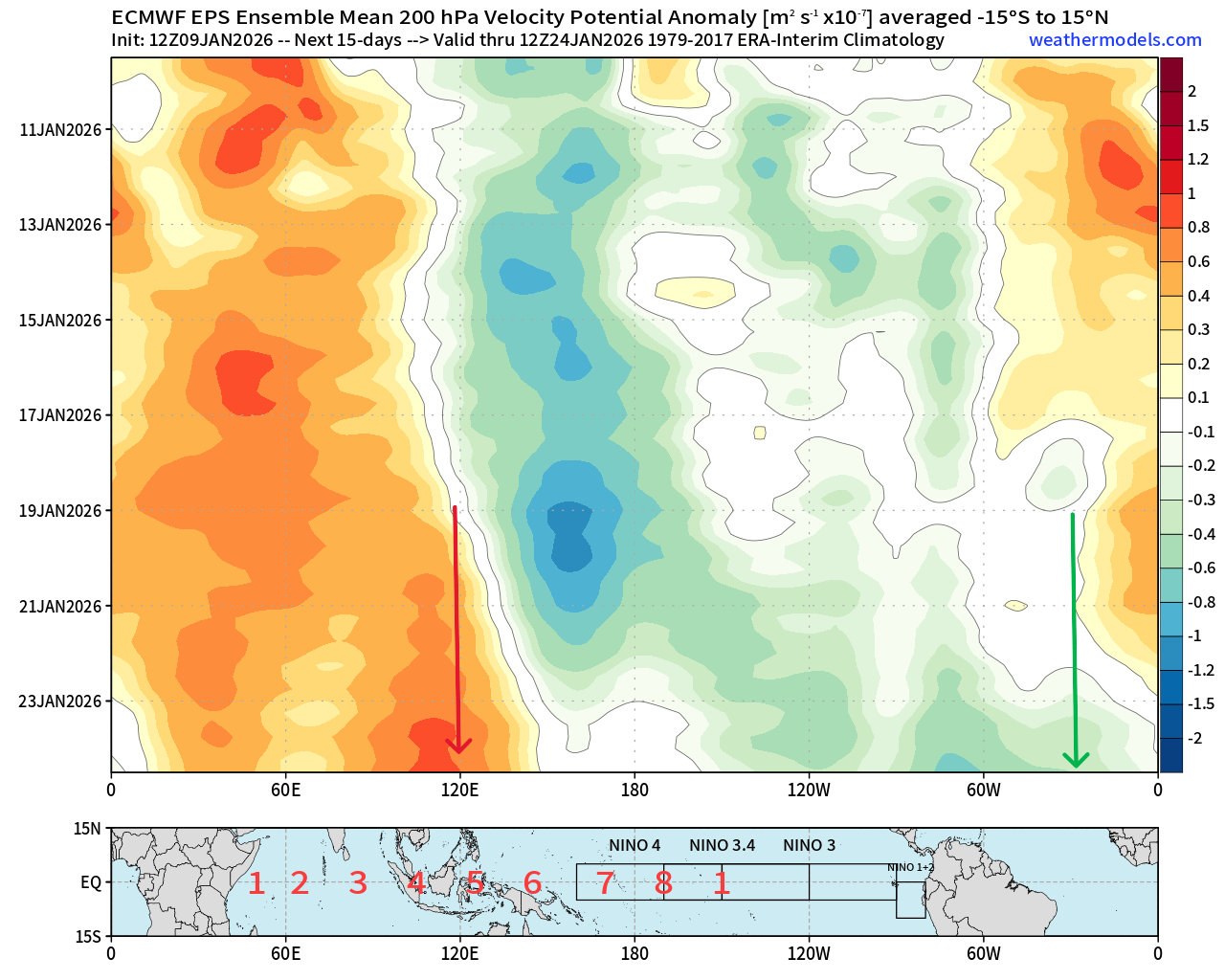
Looking ahead to jan 25+, eps moved to gefs in a big way. Ridging building to the west coast instead of digging a trough there. Makes the Jan 22-25 SE ridge very temporary (few days) before we reload. Hope that holds and think it will since mjo is progged to make a strong incursion into 7 then maybe 8
-
Both euro and cmc shifted towards gfs this run. Let’s keep this going.
-
Better to get a clean consensus at 48 hr than 120
-
At least its a step in the right direction from anything other than gfs
-
Cmc not gonna do it. H5 vort too forward and pos tilted compared to gfs (tho better than 0z)
-
Agreed. This isn’t the first time gfs showed an exciting run only to have gotten no consensus from other models. Lets see this time. Takeaway is that there IS a high-end possibility from this.
-
Yeah, aside from no blocking, this isn’t a SS wave models can see coming half a globe away. It’s more of a NS wave digging far enough south to *maybe* give us something
-
It is doing exactly what we need it to do - go neg tilt right on top of us.
-
Wow, that’s a FOLKS
-
If correct, things might throw a wrench into a canonical nina Feb and we get yet another chance then.
-
Yep i think bluewave posted that in the main enso thread. Usually it was biased the other way, and this year has been different
-
You mean when DCA almost reached 80 degrees in Jan? I seriously doubt it happens this time. Feburary, maybe.
-
Looking ahead through end of Jan, all ensembles bring a southern/SE ridge after jan 22… but gefs/geps retrogrades the ridge west toward the end of their runs. If they’re correct, that thaw will only last a few days before it gets colder again. Euro wants to keep the SE ridge all the way through, but with mjo going into 7 I think its wrong and will catch up to gefs/geps.
-
Been quiet here not because I’m not excited about the threats, just been busy with family and work. I think this is one of those things where we won’t know what will happen until 48 hours or less till onset.
-
What's good for Tennessee is good for us.
-
Didn't lose anything. Noise-level changes
-
Yeah it wasn’t looking that good yesterday and the day before, but good trends today.
-
It better be the 86-87, 02-03, 09-10 flavor not 72-73